Hurricane Darby has begun to weaken as it nears the Hawaiian Islands; the Central Pacific Hurricane Center (CPHC) in Honolulu expects the storm to rapidly weaken later tonight and tomorrow as the storm gets even closer to the Aloha State.
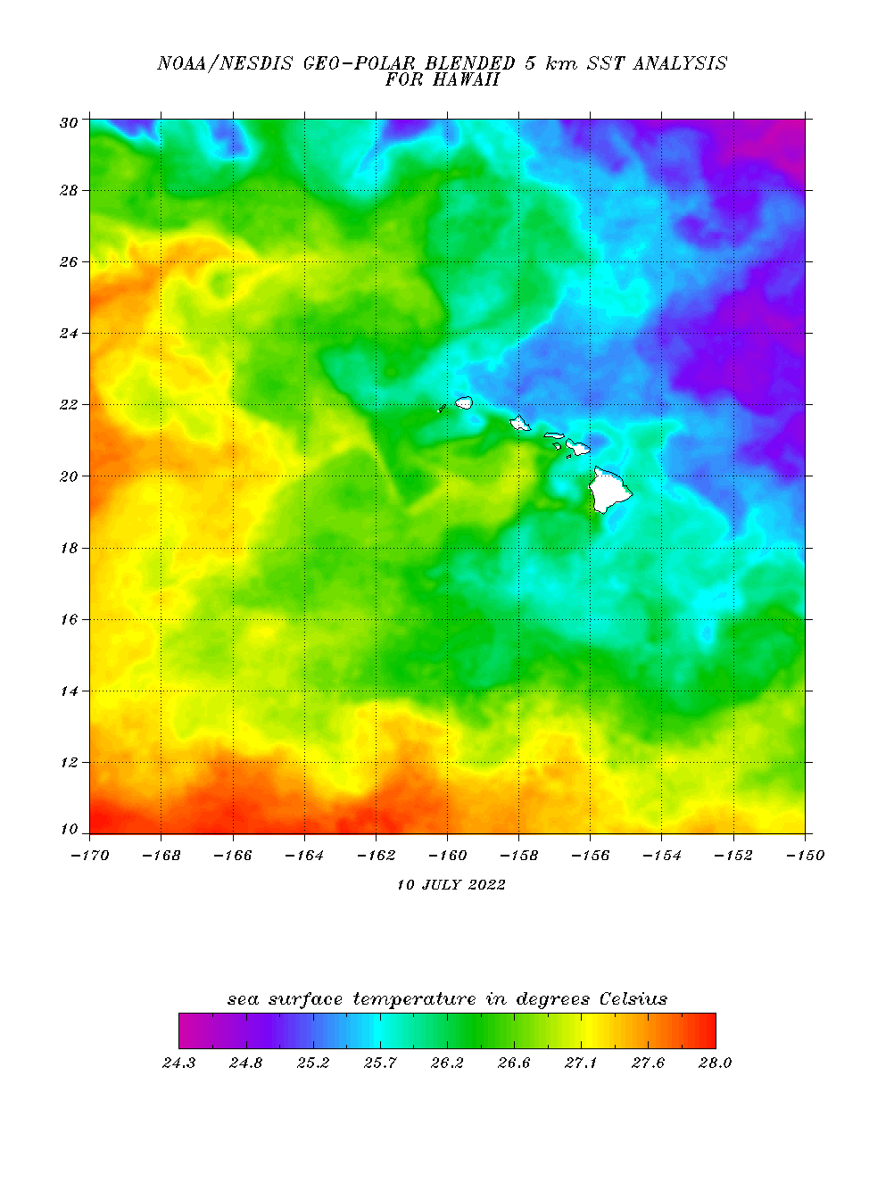
Yesterday, Darby went through a surprise intensification period, becoming a Major Hurricane with winds over 110 mph. However, since then, Darby has entered into an environment that is very hostile towards tropical cyclones. Yesterday Darby found itself in light atmospheric shear, around robust moisture, and over sea surface temperatures that were at a minimum in the upper 70s. Now, Darby is entering an area with much colder sea surface temperatures and much greater shear. Tonight, Darby is forecast to move into an area with very strong westerly shear and very dry air; when that happens, Darby should begin a process of rapid weakening.
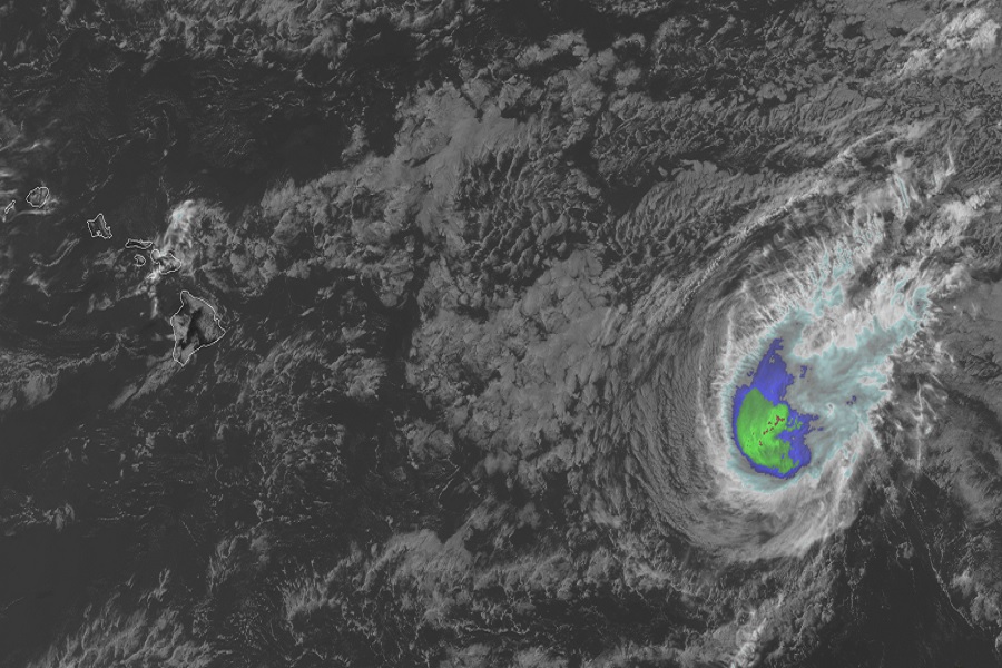
For now, Darby is located in the Central Hurricane Basin east of Hawaii at 17.5 North 143.4 West. As of 5 pm Thursday, Hawaii time, Darby was located roughly 780 miles east of Hilo Hawaii and about 980 miles east-southeast of Honolulu, Hawaii.
Darby has weakened to a Category 1 hurricane on the Saffir-Simpson hurricane wind scale. The hurricane is moving to the west at 16 mph; minimum central pressure is 983 mb or 29.03″.
Because Darby is over open water and is expected to weaken further, there are no coastal watches or warnings in effect.
The CPHC expects Darby to continue to weaken and fall apart in the coming days. The official CPHC forecast calls for Darby to weaken to a tropical storm tomorrow and weaken further to a post-tropical cyclone on Saturday before dissipating.
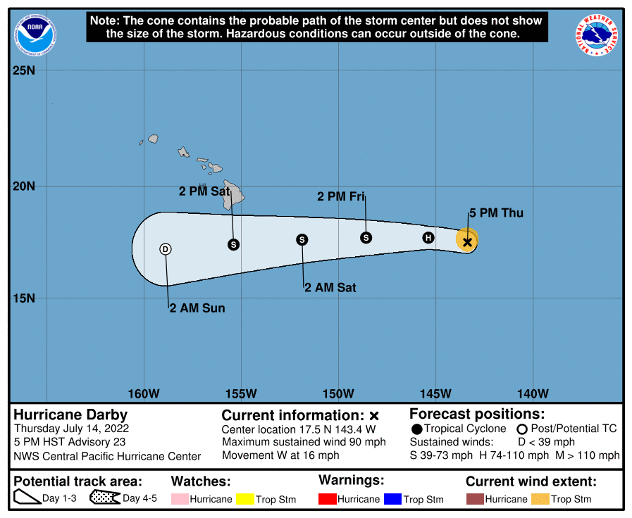
While the CPHC has the tropical storm center south of the Big Island by Saturday afternoon, it should be far enough south to only give the Big Island of Hawaii fringe effects. These effects include rough surf and enhanced tropical rain showers which could be very heavy at times, especially on east-facing slopes of Hawaii Island. While some moisture from the dissipating system could spread into some of the other islands like Maui and Oahu, much of the moisture from Darby and its remnants should impact the Big Island of Hawaii and the open ocean to its south. Most of the rain should fall in Hawaii on Sunday.
In preparation of the brush-by by the remnants of Darby this weekend, Hawaii County Civil Defense shared a bulletin with the community this afternoon. In it, they warn Darby could bring breezy trade winds, 3-5″ of rain, and 8-12′ waves to east facing shores of Hawaii Island, with 15-20′ waves from a separate swell coming from the southern hemisphere too. “In preparation for Darby, please take this time to secure outdoor items from possible wind damage and to address flooding concerns. Beach-goers, swimmers, and surfers please exercise caution as strong breaking waves, shore break, and rip currents making swimming difficult and dangerous are expected. Beaches may be closed without notice.”
