
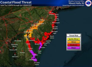
The National Hurricane Center is now calling for a storm surge from Hurricane Erin to impact the U.S. East Coast from the Jersey Shore south to central South Carolina. The greatest storm surge from the hurricane should impact North Carolina, where a 2-4′ surge is possible from Duck, North Carolina south to Cape Lookout, North Carolina. Elsewhere, a 1-3′ surge is expected which could create considerable coastal flooding.
Making matters worse, the National Hurricane Center now predicts that Hurricane Erin will become stronger and larger in the hours ahead. While no direct impact to land is expected on the current forecast track, the huge storm will be close enough to bring a variety of hazards to the U.S. east coast on its west side and Bermuda on its east side.
As of the latest advisory from the National Hurricane Center (NHC), Hurricane Erin was located about 545 miles west-southwest of Bermuda and about 365 miles south-southeast of Cape Hatteras, North Carolina. The minimum central pressure is 941 mb or 27.79″.
A Tropical Storm Warning is now in effect from north of the North Carolina / Virginia border to Chincoteague, Virginia. In addition to the area around and north of the Beaufort Inlet, a Tropical Storm Warning is also in effect for the Pamlico and Albemarle sounds. A Tropical Storm Warning means that tropical storm conditions are expected somewhere within the warning area, in this case within the next 24 hours.
A Storm Surge Warning is in effect for the area stretching from Cape Lookout to Duck, North Carolina. A Storm Surge Warning means there is a danger of life-threatening inundation, from rising water moving inland from the coastline during the next 36 hours.
“This is a life-threatening situation. Persons located within these areas should take all necessary actions to protect life and property from rising water and the potential for other dangerous conditions,” warns the NHC. “Promptly follow evacuation and other instructions from local officials.”
The government of Bermuda has also issued a Tropical Storm Watch for Bermuda. A Tropical Storm Watch means that tropical storm conditions are possible within the watch area, generally within 48 hours.
Hurricane Erin is moving toward the north near 13 mph. According to the NHC, a turn toward the north-northeast is expected later today and tonight, followed by a faster motion
toward the northeast and east-northeast by Thursday and Friday. On the forecast track, the center of Erin will move over the western Atlantic between the U.S. east coast and Bermuda today through early Friday, and then pass south of Atlantic Canada Friday and Saturday.

Maximum sustained winds have increased to near 110 mph with higher gusts. The NHC says some additional strengthening is likely during the next day or so, and Erin could become a major hurricane again by tonight. However, weakening is likely to begin by Friday, but Erin is forecast to remain a hurricane into the weekend.
Erin is a very large hurricane. Hurricane-force winds extend outward up to 90 miles from the center and tropical-storm-force winds extend outward up to 265 miles. The storm is expected to more than double in size within the next 36 hours.
Tropical storm force wind conditions are expected over portions of the North Carolina Outer Banks and the Virginia coastline beginning late today. Elsewhere along the mid-Atlantic and southern New England coast, wind gusts to tropical storm force are likely Thursday through early Friday. Tropical storm conditions are possible on Bermuda Thursday and Friday.
Swells generated by Erin will affect the Bahamas, Bermuda, the east coast of the United States, and Atlantic Canada during the next several days. These rough ocean conditions are expected to cause life-threatening surf and rip currents.
The combination of a dangerous storm surge and the tide will cause normally dry areas near the coast to be flooded by rising waters moving inland from the shoreline. The deepest water will occur along the immediate coast where the surge will be accompanied by large and dangerous waves. Surge-related flooding depends on the relative timing of the surge and the tidal cycle, and can vary greatly over short distances.
Easy advice: avoid the ocean until Hurricane Erin is long gone! https://t.co/iSBD970v8x
— the Weatherboy (@theWeatherboy) August 20, 2025
The outer bands of Erin may bring 1 -2″ inches of rainfall to the Outer Banks of North Carolina this afternoon into Thursday. Much of the hurricane’s rain will fall over the open waters of the Atlantic Ocean.
