Another extremely dangerous weather situation is unfolding today across portions of southern California, prompting the National Weather Service to issue a rare “Particularly Dangerous Situation” alert for the region. Hurricane force winds and critical fire weather will return to the area today, putting on edge a city that has been dealing with an epic destructive stretch of fire weather that has killed more than 25 people and destroyed more than 15,000 structures.
The Los Angeles office of the National Weather Service warns, “Take action now to prepare your home and loved ones for another round of EXTREME WIND and FIRE WEATHER!”
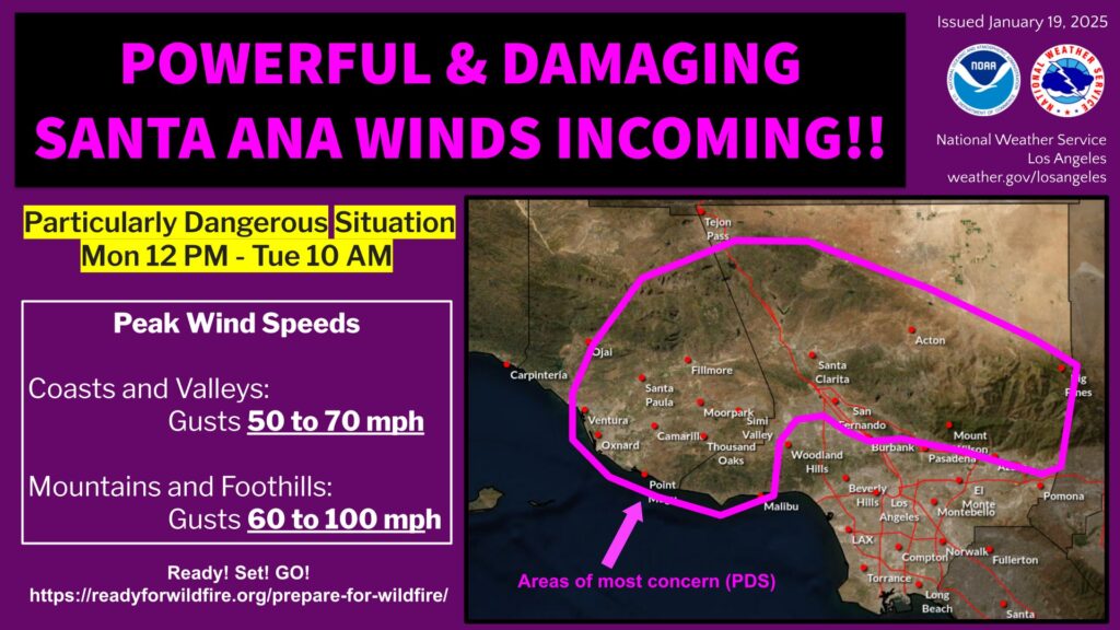
The worst of the winds are expected between noon today and 10 am tomorrow. Winds will gust to 50 – 70 mph at the coasts and valleys while the mountains and foothills could see gusts of 60 to 100 mph. Hurricane force winds are winds greater than 74 mph.
The latest in a seemingly endless series of Santa Ana wind events continues to unfold today across southern California. A strong vorticity max was dropping southward through Nevada into eastern California this morning, helping to carve a trough just to the east of the region today. Upper level winds will become northerly and increase sharply today. Winds are expected to increase quickly in the mountains of Los Angeles and Ventura counties today and overspread the valleys, pushing across coastal plain by afternoon. Winds are expected to peak this afternoon or early tonight, then remain strong overnight and early Tuesday. Winds should slowly diminish tomorrow afternoon.
The highest gusts will likely be focused near Santa Clarita Valley and near the Highway 118/126 corridors, affecting cities including Simi Valley, Moorpark, Porter Ranch, and Santa Paula.
In addition, with the strong upper level wind support, there is the potential for locally strong/damaging mountain wave wind activity across the foothills of the San Gabriel and San Fernando Valleys, mainly focused near the Highway 210/118 corridors from Porter Ranch to San Fernando, eastward to La Crescenta/Altadena, extending to Azusa/Glendora and Monrovia. The highest probability of any stronger mountain wave wind activity would most likely be from 2 pm this afternoon to 2 am Tuesday.
In addition to the severe winds which have prompted the issuance of wind warnings, conditions will be especially dry, making it ripe for fires to quickly spread. People throughout this area should be on alert should they need to quickly flee for safety from fast-moving fires. Fire Weather conditions should persist through Tuesday afternoon and people in southern California should not let their guard down, especially with some fires still burning in the region.
