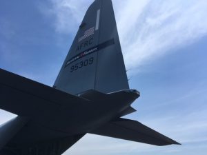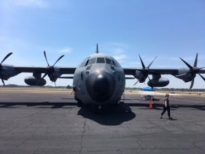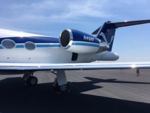
The 2017 Atlantic Hurricane Season begins on June 1; to generate awareness for the season and to highlight the efforts of Hurricane Hunters that probe storms, a Hurricane Hunter tour was launched along the east coast of North America. At the Orlando, Florida stop of the tour in May, aircraft, crew, and various tropical weather experts were available to meet with and explore.
Two very different aircraft were showcased that are used in the hurricane forecasting efforts: the WC-130 and the Gulfstream IV.
The WC-130 highlights what is commonly known as the “Hurricane Hunter Aircraft” which is operated by the Air Force Reserve 53rd Weather Reconnaissance Squadron (WRS), the world’s only operational military weather reconnaissance unit. The WRS is based out of Keesler Air Force Base in Biloxi, Mississippi. It is officially named a Lockheed WC-130 J aircraft and it’s sturdy design and large size allow it to fly directly into hurricanes at altitudes of 10,000 feet or lower. Interestingly, it is propeller driven which is an advantage when employing radiosondes and buoys used to gather data as relatively slow speeds of under 180 knots (207 mph) are needed to drop them.
The Gulfstream IV, also known as simply a G-IV jet, is operated by the National Oceanic and Atmospheric Administration (NOAA.) It is a less rugged aircraft than the Lockheed WC-130 and is designed to cruise at altitudes of 40,000 feet or higher. Being a jet, it flies at much faster speeds than the WC-130 and both its high speed and altitude do not allow for radiosondes or buoys to be dropped.
The term “hurricane hunters” was first applied to missions flown in 1946. The US Air Force reserve hurricane hunters fly weather missions anywhere from midway in the Atlantic Ocean all the way west to Hawaii. They have on occasion flown into typhoons over the Pacific Ocean and even been employed to gather data in winter storms. The 53rd WRS hurricane hunters operate ten separate Lockheed aircraft and typically penetrate the hurricane’s eye several times per mission at altitudes between 500 feet and 10,000 feet.

As one can guess, when flying at these levels into a hurricane, the ride can be very bumpy at times. Air Force Reservist, crew member, and meteorologist Major Toby Baker reminisced on a ride that is hard for him to forget. “Tropical Storm Rafael in 2012 was a tropical storm that was beefing up into a category 2 hurricane,” Major Baker described. “While it was rapidly gaining strength it was also experiencing dry air intrusion. So, it was going through a chaotic period where it was trying to build and die at the same time. This caused alot of unpredictable winds and extreme turbulence. Instead of a neatly organized wall cloud associated with a typical band of a more well developed hurricane, it was more like a brier patch of individual thunderstorm cells, making the ride way worse and tougher to gauge when the turbulent times were coming up than normal. We were pretty much bounced all over the place.”
All the crew members, including the pilot of Hurricane Hunter Aircraft are meteorologists. Thus, their experiences can be appreciated even more as they remember analyzing what is going on around them while they are in-flight.
The Hurricane Hunter’s job is simple in intention even if the job itself is much more difficult: get as much data as possible and convey it in real-time to the National Hurricane Center (NHC) and other meteorologists.
Warren Madden is the Aerial Reconnaissance Coordinator with the US Air Force at the NHC in Miami. He is the one who tells the pilot where to go and what path to take after conferring with NHC meteorologists. “If there is a system that we want data on, my office calls over to the Air Force reservists in Biloxi and/or to the NOAA crew soon to be based out of Lakeland, Florida and we tell them what we want them to do, ” Madden says. “Once they are up in the air our office becomes the the communication center as we make sure the data from the planes is coming in from them properly and we are receiving it correctly as well. We then send the data out as quickly as possible not only to our team of meteorologists at the NHC but other meteorologists as well, both public and private. Also, we begin the process of making sure the media has the latest information on the storm as well.”

The Gulfstream IV’s job is a bit different than the lower-altitude WC-130. It is also often directed to gather data for the purpose of helping meteorologists forecast the current tropical system but it is able to collect data over a larger area. Because of it’s speed, it can collect data on a cold front hundreds of miles to the system’s northwest or gather information about the wind shear of the atmosphere upstream of the storm. Often, the goal of the mission is to gather data that will be used more for research than current analysis. NOAA officials will instruct the pilot and the on-board crew of commissioned officers from NOAA on what type of data to collect. All of the data acquired can also be seen in real-time by meteorologists on the ground but not all of the data that the GulfStream IV sends out is as relevant for them as the WC-130’s data is.
NOAA pilot and meteorologist Dave Cowan explained, “What makes the G4 that is here today, and also our C3 Orion aircraft that isn’t, special is that it is not necessarily involved in the day to day beast that is forecasting the hurricane, the track and intensity forecasts, etcetera. They are research platforms which have the ultimate goal of being a part of making hurricane forecasting better.”