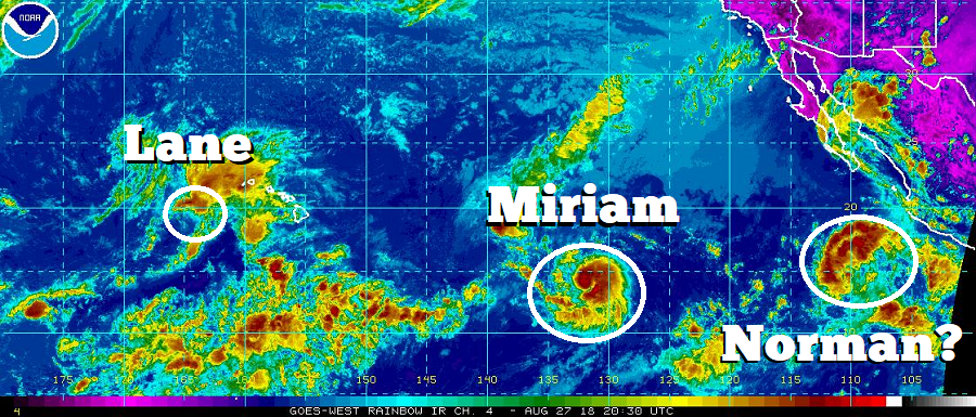
While the Atlantic Hurricane Basin remains quiet with no tropical cyclones expected to form over the next five days according to the National Hurricane Center, the Eastern Pacific Basin is ripe with activity –including a future hurricane that could impact Hawaii. While Tropical Storm Lane is moving away from Hawaii, the satellite map shows Miriam heading to the Aloha State. Fortunately for the state rocked by recent earthquakes, floods, volcanic eruption, and of course, Hurricane Lane, it appears Miriam will curve north of Hawaii well east of it, not bringing any direct impacts to the state. However, while Miriam is currently forecast to move away, a new storm to be named Norman may head right for it.
Showers and thunderstorms associated with an area of low pressure located about 475 miles southwest of Manzanillo, Mexico, continue to show signs of organization. Satellite imagery indicates that the circulation is currently elongated and lacks a well-defined center. According to the National Hurricane Center, environmental conditions are expected to be conducive for additional development of this disturbance and a tropical depression is likely to form tonight or Tuesday while the system moves generally west-northwestward at around 10 mph. The National Hurricane Center believes there’s a 90% chance that a tropical cyclone will form here within the next 48 hours. Beyond that, forecast guidance says the system will become a Tropical Storm and eventually a Hurricane, earning the name “Norman” as it does so.
Unlike Miriam which is forecast to curve to the north, Norman is forecast to head west, approaching Hawaii sometime beyond September 7. Because of large track errors in forecast guidance this far out, it is way too soon to say with certainty if landfall with Hawaii will or won’t happen. It is important for people in or planning to be in Hawaii know that the peak of hurricane season here and tropical cyclone threats can exist through to the end of November. If people used their supplies from their Hurricane Action Plan due to Hurricane Lane, it is important that they re-stock them ahead of the next tropical cyclone threat.