Hurricane Pono’s remnants are bringing flooding rains to portions of New Mexico, Arizona, and Texas today. Hurricane Polo made a second landfall along the northwest coast of Mexico earlier today after making its initial landfall in Baja California last night. While the system is quickly losing its tropical cyclone characteristics and wind, it’s dumping epic amounts of rain over portions of the U.S. southwest that don’t typically get these heavy tropical downpours.
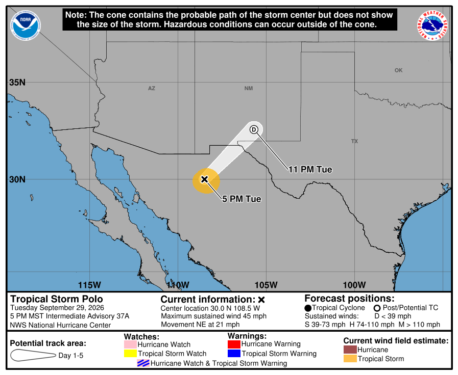
In the latest advisory from the National Hurricane Center, Polo, now just a tropical storm, was located about 200 miles northeast of Guaymas, Mexico. Maximum sustained winds were down to 45 mph making it a minimal tropical storm while minimum central pressure was up to 996 mb or 29.41″.
Tropical Storm Polo is moving toward the northeast near 21 mph and this motion is expected to continue tonight. Polo is expected to dissipate within the next several hours but its moisture will continue to surge into the United States from Mexico.
Tropical storm conditions, especially in gusts, are still occurring well inland over northwestern Mexico. A Wind Advisory is in also in effect for portions of southern New Mexico and far western Texas where strong gusty winds are possible late today and tonight in association with Polo’s remnants.
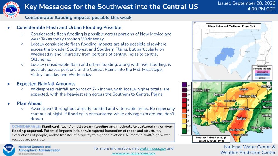
But the big news will be very heavy rain moving into the U.S.. According to the National Hurricane Center, Polo is expected to produce rainfall totals of 4 to 6 inches across southern and central portions of Sonora with isolated
maximum totals of 8 inches. This rainfall may produce life-threatening flooding and mudslides, especially in areas of steep terrain. This heavy rain will spread into portions of New Mexico, Arizona, and Texas where an additional 4-6″ of rain is possible.
,
An upper-level low over the Desert Southwest is forecast to move into New Mexico by Wednesday morning, drawing tropical moisture from the remnants of Hurricane Polo northeastward. Slow-moving thunderstorms will continue this evening across southeast Arizona and western New Mexico, with a line of heavy storms expected overnight from southern and eastern New Mexico into West Texas, including the Pecos River valley.
Saturated soils, burn scars, canyons, and low-water crossings are especially vulnerable, where locally significant flash flood concerns exist.
Storms near the remnant circulation could also produce damaging winds and a brief tornado over southeast New Mexico and West Texas. On Wednesday, a dry slot should move across eastern New Mexico and the Panhandles, finally ending the heavy rain over those hard-hit areas. Meanwhile, a strengthening low over the High Plains will pull deep Gulf moisture northward. By Thursday, the trough should weaken and stall over the Plains as a cold front settles south.
