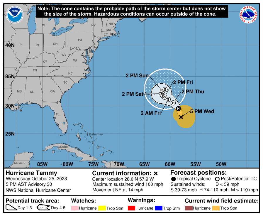
Hurricane Tammy’s forecast track by the National Hurricane Center in Miami, Florida has shifted again, with meteorologists there at the forecast facility suggesting the system will stall out and weaken east of Bermuda with time.
As of the latest advisory from the National Hurricane Center (NHC), Tammy was a 100 mph hurricane located about 510 miles southeast of Bermuda. It is moving to the northeast at 14 mph while the minimum central pressure is at 969 mb or 28.62″.
The NHC says Tammy should turn to the north tonight, followed by a turn to the west-northwest by Friday. As it moves about, the NHC says its forward speed will also slow.
While Tammy’s maximum sustained winds are at 100 mph now, the NHC expects steady weakening over the next few days. By Thursday, the NHC expects Tammy to transition to a powerful extratropical cyclone.
For now, hurricane-force winds extend outward up to 25 miles from the storm’s center and tropical-storm-force winds extend outward up to 175 miles. Because winds are far away from land and should remain that way for the next 2 days, no hurricane or tropical storm watches or warnings are in effect at this time.
Earlier forecasts from the NHC had the storm curving back towards Bermuda, perhaps with a direct hit, before continuing west closer to the U.S. East Coast. Now, the latest NHC forecast stalls the storm east of Bermuda, avoiding any direct impact.
While direct impacts aren’t forecast for now, indirect impacts in the form of surf are expected over a broad area. Swells generated by Tammy will continue to affect portions of
Bermuda, the northern Leeward Islands, the British and U.S. Virgin Islands, and Puerto Rico during the next couple of days. According to the NHC, these swells are likely to cause life-threatening surf and rip current conditions. Even expert swimmers and surfers are encouraged to avoid entering the ocean until smoother conditions return.
