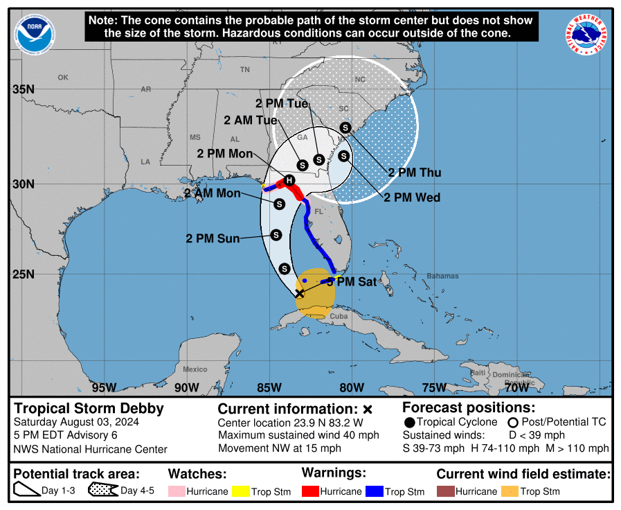
The National Hurricane Center has issued Hurricane Warnings for portions of the Florida coast as Tropical Storm Debby takes shape and intensifies. While Florida will feel the first impacts from this tropical cyclone, residents up the east coast as far north as New York City should be on alert and stay appraised of the latest forecast track for this growing storm system.
As of the 5 pm advisory from the National Hurricane Center, the center of Tropical Storm Debby was located about 100 miles west-southwest of Key West, Florida; with maximum sustained winds and minimum central pressure down to 1007 mb or 29.74″, the storm was moving to the northwest at 15 mph.
According to the National Hurricane Center (NHC), this motion is expected to continue tonight, followed by a northward turn on Sunday and a slower northeastward motion Sunday night and Monday. Strengthening is also expected over this period. On the latest NHC forecast track, the center of Debby will move across the southeastern and eastern Gulf of Mexico tonight and Sunday, reaching the Florida Gulf coast late Sunday night or Monday. Strengthening is expected as Debby crosses the Gulf of Mexico, and the system is likely to be at or near hurricane strength when it reaches the Florida Gulf coast.
Due to the strengthening system, a Hurricane Warning is now in effect for the Florida Gulf coast from the Suwannee River to the Ochlockonee River while a Tropical Storm Warning is now in effect for the Florida coast west of the Ochlockonee River to Indian Pass, and for the Florida coast east of the Suwannee River to Yankeetown. A Storm Surge Warning is also now in effect west of the Aucilla River to Indian Pass. A Tropical Storm Watch is now in effect for the Florida coast west of Indian Pass to Mexico Beach and the Florida Keys north of the Seven Mile Bridge to the Channel 5 Bridge. A Storm Surge Watch is in effect for Bonita Beach northward to Aripeka, including Tampa Bay and Charlotte Harbor.
Each watch or warning means something different. A Hurricane Warning means that hurricane conditions are expected
somewhere within the warning area. A warning is typically issued 36 hours before the anticipated first occurrence of tropical-storm-force winds, conditions that make outside preparations difficult or dangerous. Preparations to protect life and property should be rushed to completion. A Tropical Storm Warning means that tropical storm conditions are expected somewhere within the warning area within 36 hours. A Hurricane Watch means that hurricane conditions are possible within the watch area. A watch is typically issued 48 hours before the anticipated first occurrence of tropical-storm-force winds, conditions that make outside preparations difficult or dangerous. A Tropical Storm Watch means that tropical storm conditions are
possible within the watch area, generally within 48 hours. A Storm Surge Warning means there is a danger of life-threatening inundation, from rising water moving inland from the coastline, during the next 36 hours in the indicated locations.
The NHC warns, “This is a life-threatening situation. Persons located within these areas should take all necessary actions to protect life and property from rising water and the potential for other dangerous conditions. Promptly follow evacuation and other instructions from local officials.” The NHC adds, “Interests elsewhere in Florida and the southeastern coast of the United States should monitor the progress of this system.”
Numerous hazards are expected on land as Debby approaches: destructive winds, storm surge, flooding rains, and tornadoes.
Hurricane conditions are expected in the hurricane warning area by late Sunday night or Monday morning, with tropical storm
conditions expected to arrive during the day on Sunday. Hurricane conditions are possible in the hurricane watch area by Sunday night, with tropical storm conditions expected to begin on Sunday. Tropical storm conditions are expected to spread northward over the tropical storm warning areas this evening and continuing through Sunday. Tropical storm conditions are possible in the watch area in the Florida Keys tonight, and in the Florida Panhandle by late Sunday or Monday morning.
The combination of storm surge and tide will cause normally dry areas near the coast to be flooded by rising waters
moving inland from the shoreline. The water could reach up to 4-7 feet from Yankeetown to Aucilla River while the surge could be up to 3-5 feet for Aripeka to Yankeetown and Aucilla River to Indian Pass if the peak surge occurs at the time of high tide. The surge could be 2-4′ for Tampa Bay, Charlotte Harbor, and the area from Bonita Beach to Aripeka too.
Debby is expected to produce rainfall totals of 6-12″, with maximum rainfall totals up to 18″, across portions of Florida and along the Southeast U.S. coast this weekend through Thursday. This rainfall will likely result in areas of considerable flash and urban flooding, with significant river flooding expected.
Tornadoes are also possible across the Florida Keys and the western Florida Peninsula through tonight, expanding across much of northern and central Florida on Sunday.