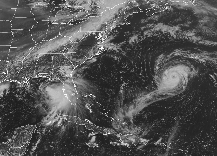
Meteorologists at the Miami, Florida based National Hurricane Center are busy forecasting the arrival of two hurricanes to land: Paulette and Sally. Paulette is a hurricane today and is located roughly 195 miles southeast of Bermuda; is it forecast to strike Bermuda tomorrow as a hurricane, prompting Hurricane Warnings there. Sally is a tropical storm today; located roughly 240 miles east southeast of the Mouth of the Mississippi River, it is expected to strengthen into a hurricane before striking the central Gulf Coast late Monday or early Tuesday, prompting Hurricane Warnings there too. Both of these storms bring the potential to claim lives and property and people in the Hurricane Warning areas should act swiftly to take measures to protect both.
Today, Hurricane Paulette is moving toward the northwest near 13 mph and this general motion is expected through tonight. A turn toward the north with a decrease in forward speed is forecast on Monday, followed by a faster northeastward motion Monday night and Tuesday. On the forecast track, the center of Paulette will move near or over Bermuda Monday morning.
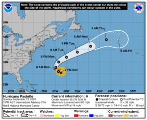
Maximum sustained winds inside Paulette are near 80 mph and the National Hurricane Center expects additional strengthening as Paulette approaches Bermuda late tonight and early Monday. The center of Paulette is forecast to pass right over or very close to Bermuda as a dangerous hurricane. After impacting Bermuda, Paulette could strengthen further as it turns to the northeast and moves away from land into the central Pacific.
Damaging winds, storm surge flooding, heavy rains, and high surf are all forecast to lash Bermuda beginning tonight.
Hurricane force wind conditions are expected to reach Bermuda by tonight or early Monday. Winds are expected to first reach tropical storm strength by this evening, making outside preparations difficult or dangerous. The National Hurricane Center recommends that preparations to protect life and property should be rushed to completion now ahead of the arrival of those winds.
A dangerous storm surge is expected to produce significant coastal flooding on Bermuda in areas of onshore winds. Near the coast, the surge will be accompanied by large and destructive waves.
Paulette will bring periods of heavy rain to Bermuda through Monday, with rainfall of 3-6″ expected. This will create flood problems on the island.
Swells generated by Paulette are affecting portions of the Leeward Islands, the Greater Antilles, the Bahamas, Bermuda, and the east coast of the United States. These swells are likely to cause life-threatening surf and rip current conditions across a broad area. People around Bermuda and much of the U.S. East Coast should avoid the water until the ocean calms; even expert swimmers and surfers could be at risk from strong currents generated by the intensifying hurricane.
While Bermuda will be hit by Hurricane Paulette first, the impacts from a forecasted Hurricane Sally won’t be far behind. Sally can produce significant damage along its impact zone, with a catastrophic storm surge possible for some. Due to those threats, the National Hurricane Center has issued more than a Hurricane Warning for the area.
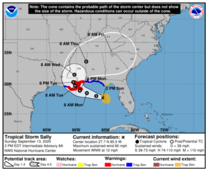
As of now, a Storm Surge Warning is in effect for the area from Port Fourchon, Louisiana to the Mississippi/Alabama state border, and for Lake Pontchartrain, Lake Maurepas, and Lake Borgne. The Hurricane Warning stretches from Morgan City, Louisiana to Ocean Springs, Mississippi and includes Lake Pontchartrain and Lake Maurepas including metropolitan New Orleans. A Storm Surge Watch is in effect for the region from the Mississippi/Alabama state border to the Alabama/Florida state border. A Hurricane Watch is in effect for the area east of Ocean Springs, Mississippi to the Alabama/Florida state border. A Tropical Storm Warning is in effect for the area east of Ocean Springs, Mississippi to Indian Pass, Florida and for the area between Intracoastal City, Louisiana to west of Morgan City, Louisiana. A Tropical Storm Watch is in effect for the area in between Indian Pass, Florida to the Ochlockonee River in Florida.
Each of these watches and warnings mean different things. A Storm Surge Warning means there is a danger of life-threatening inundation, from rising water moving inland from the coastline, during the next 36 hours in the indicated locations.A Hurricane Warning means that hurricane conditions are expected somewhere within the warning area; a Hurricane Warning is typically issued 36 hours before the anticipated first occurrence of tropical-storm-force winds, conditions that make outside preparations difficult or dangerous. Preparations to protect life and property should be rushed to completion there. A Tropical Storm Warning means that tropical storm conditions are expected somewhere within the warning area within 36 hours. A Storm Surge Watch means there is a possibility of life-threatening inundation, from rising water moving inland from the coastline, in the indicated locations during the next 48 hours. A Hurricane Watch means that hurricane conditions are possible within the watch area. A Tropical Storm Watch means that tropical storm conditions are possible within the watch area, in this case within 12 to 24 hours.
For now, Sally is moving toward the west-northwest near 12 mph as a tropical storm. According to the National Hurricane Center, a west-northwestward or northwestward motion is expected through Monday. On Monday night, a decrease in forward speed and a turn toward the north-northwest is forecast to occur, followed by a slow north-northwestward motion on Tuesday. Based on the forecast track, the center of Sally will move over the eastern Gulf of Mexico today, move over the north-central Gulf of Mexico tonight and Monday, and approach the north-central Gulf Coast within the hurricane warning area late Monday and Monday night. Sally is expected to move farther inland over southeastern Louisiana or southern Mississippi on Tuesday and Tuesday night.
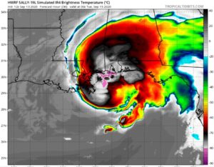
Maximum sustained winds are near 60 mph with higher gusts inside Sally now. However, strengthening is expected over the next day or so, and Sally is forecast to become a hurricane on Monday, with some additional strengthening possible before landfall Monday night. The latest minimum central pressure estimated from data from a NOAA reconnaissance aircraft is 998 mb or 29.48 inches and that pressure is forecast to continue to drop prior to landfall.
The National Hurricane Center describes Sally’s inevitable landfall as a “a life-threatening situation.” They add, “Persons located within these areas should take all necessary actions to protect life and property from rising water and the potential for other dangerous conditions. Promptly follow evacuation and other instructions from local officials.”
A very significant storm surge could occur from Sally. The combination of a dangerous storm surge and the tide will cause normally dry areas near the coast to be flooded by rising waters moving inland from the shoreline. The water could reach the following heights above ground somewhere in the indicated areas if the peak surge occurs at the time of high tide:
- Mouth of the Mississippi River to Ocean Springs, MS including Lake
Borgne: 7-11′ - Port Fourchon, LA to Mouth of the Mississippi River: 4-7′
- Ocean Springs, MS to MS/AL Border: 4-7′
- Lake Pontchartrain and Lake Maurepas: 4-6′
- MS/AL Border to AL/FL Border including Mobile Bay: 2-4′
- AL/FL Border to Chassahowitzka, FL including Pensacola Bay, Choctawhatchee Bay, and Saint Andrew Bay: 1-3′
- Burns Point, LA to Port Fourchon, LA: 1-3′
The National Hurricane Center also warns that the overtopping of local levees outside of the Hurricane and Storm Damage Risk Reduction System is possible where local inundation values may be higher than those shown above.
The deepest water will occur along the immediate coast in areas of onshore winds, where the surge will be accompanied by large and damaging waves. Surge-related flooding depends on the relative timing of the surge and the tidal cycle, and can vary greatly over short distances.
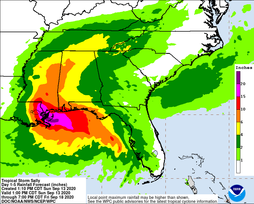
Sally will also bring destructive winds and flooding rains to the coast. Hurricane force wind conditions are expected within the warning area starting late Monday. Tropical storm conditions are possible within the watch area and expected within the warning area beginning Monday. Sally is expected to produce additional rainfall of 1-3″ with isolated amounts of 6″ across southwestern Florida through Monday. This rainfall may produce flash and urban flooding and prolong high flows and ongoing minor flooding on rivers across west-central Florida. Sally is expected to be a slow moving system resulting in significant flash flooding for the central Gulf Coast through the middle of the week. Sally is expected to produce rainfall of 6-12″ inches with isolated amounts of 20″ inches over portions of the central Gulf Coast from the western Florida Panhandle to far southeast Louisiana from Monday through the middle of the week. From there, Sally is forecast to turn inland Wednesday and track into the Southeast with rainfall of 4-8″ possible farther inland across much of Mississippi and Alabama with further heavy rain anticipated for portions of Tennessee, northern Georgia and western North Carolina. Flash and urban flooding is possible, as well as minor to isolated moderate flooding on rivers for Mississippi and Alabama. Flash, urban, and minor river flooding is possible for portions of Tennessee, northern Georgia and western North Carolina.
Swells from Sally are affecting the west coast of the Florida peninsula, the coast of the Florida Panhandle, and will be spreading northwestward along the northern Gulf coast through tonight. These swells are likely to cause life-threatening surf and rip current conditions. People, including expert swimmers and surfers, should avoid the Gulf of Mexico until calm waters return well after Sally’s landfall.