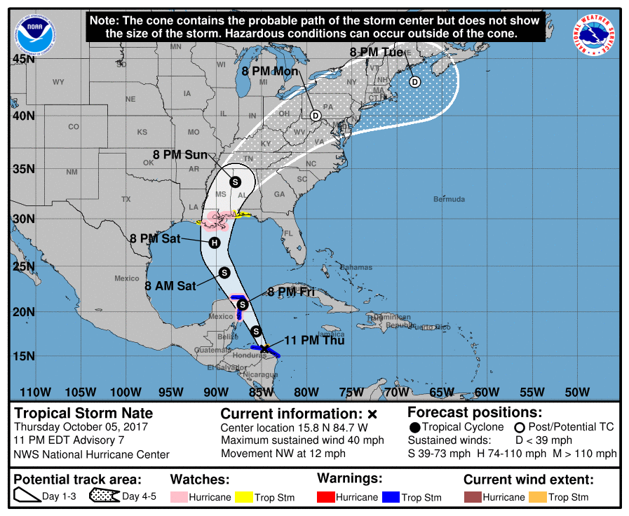
The National Hurricane Center has issued Hurricane Watches ahead of the expected landfall of Nate. In their latest forecast update, the National Hurricane Center expects an intensifying hurricane to landfall near New Orleans late Saturday or early Sunday. Nate, now a Tropical Storm, is expected to become a hurricane on Saturday as it sits in the open waters of the Gulf of Mexico prior to landfall. Damaging winds, flooding rains, and coastal storm surge flooding could occur as Nate strikes the US coast.
A Storm Surge Watch has been issued from Morgan City, Louisiana, eastward to the Alabama/Florida border, including the northern and western shores of Lake Pontchartrain. A Storm Surge Watch means there is a possibility of life-threatening inundation, from rising water moving inland from the coastline, in the indicated locations during the next 48 hours.
A Hurricane Watch has been issued from Morgan City, Louisiana, eastward to the Mississippi/Alabama border, including metropolitan New Orleans, Lake Pontchartrain, and Lake Maurepas. A Hurricane Watch means that hurricane conditions are possible within the watch area. Residents and visitors in this region should act on their Hurricane Action Plan now.
A Tropical Storm Watch has been issued from the Mississippi/Alabama border eastward to the Okaloosa/Walton County Line in Florida. A Tropical Storm Watch has also been issued west of Morgan City to Intracoastal City, Louisiana. A Tropical Storm Watch means that tropical storm conditions are possible within the watch area, generally within 48 hours.
As of 11pm, the center of Tropical Storm Nate was located close to the coast of eastern Honduras near latitude 15.8
North, longitude 84.7 West. Nate is moving toward the northwest near 12 mph. According to the National Hurricane Center, Nate is expected to turn toward the north-northwest overnight, with Nate accelerating along that heading through Saturday. On the forecast track, the center of Nate will move offshore the eastern coast of Honduras during the next several hours, move across the northwestern Caribbean Sea on Friday, and reach the eastern coast of the Yucatan peninsula Friday evening. Nate will then move into the southern Gulf of Mexico Friday night and approach the northern Gulf coast Saturday evening.
Nate is a fairly compact storm for now. Tropical-storm-force winds extend outward up to 60 miles, mainly to the northeast of the center. The estimated minimum central pressure is 1000 mb (29.53 inches).
