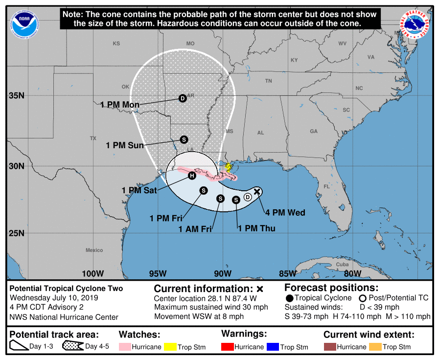
The National Hurricane Center has issued Hurricane and Tropical Storm Watches up for portions of the central Gulf of Mexico ahead of what’ll likely become Hurricane Barry. A Storm Surge Watch is also in effect for portions of the Gulf Coast too. There is no tropical cyclone yet but the National Hurricane Center expects one to form very soon and go through a period of quick intensification in the coming days.
Right now, a Storm Surge Watch has been extended westward from the mouth of the Pearl River to Intracoastal City, Louisiana. A Hurricane Watch has been issued from the Mouth of the Mississippi River westward to Cameron Louisiana. A Tropical Storm Watch has been issued from north of the Mouth of the Mississippi River to the Mouth of the Pearl River.
The watches each mean different things. A Storm Surge Watch means there is a possibility of life-threatening inundation from rising water moving inland from the coastline in the indicated locations during the next 48 hours. A Hurricane Watch means that hurricane conditions are possible within the watch area. A watch is typically issued 48 hours before the anticipated first occurrence of tropical-storm-force winds conditions that make outside preparations difficult or dangerous. A Tropical Storm Watch means that tropical storm conditions are possible within the watch area generally within 48 hours. Interests elsewhere along the U.S. Gulf Coast from the Upper Texas Coast to the Florida Panhandle should monitor the progress of this system. Even away from the immediate coastline, extremely heavy rain could fall, creating life-threatening inland floods.
As of 5pm ET, a broad disturbance was centered near latitude 28.1 North, longitude 87.4 West. The system is moving toward the west-southwest near 8 mph (13 km/h). A motion toward the west-southwest or southwest is expected through Thursday morning, followed by a turn toward the west late Thursday and a turn toward the west-northwest on Friday. By early Saturday, a northwestward motion is expected. On the forecast track, the system is expected to approach the central U.S. Gulf Coast this weekend.
Reports from an Air Force Reserve reconnaissance hurricane hunter aircraft indicate that maximum sustained winds are near 30 mph (45 km/h) with higher gusts. According to the National Hurricane Center, strengthening is forecast during the next 72 hours, and the disturbance is forecast to become a tropical depression Thursday morning, a tropical storm Thursday night, and a hurricane on Friday. The estimated minimum central pressure based on data from the aircraft and surface observations is 1011 mb or 29.86 inches.
Residents in and around the watch area are encouraged to rush their Hurricane Action Plans to completion. Even though landfall of a hurricane is expected on Friday, heavy rains and gusty winds will impact the Gulf of Mexico well ahead and well after that impact.
