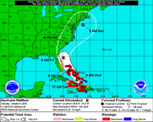
The National Hurricane Center has issued new watches ahead of Hurricane Matthew’s expected arrival to the waters along the United States east coast.
The National Hurricane Center in Miami, Florida has issued HURRICANE WATCHES for the east coast of Florida from Deerfield Beach, Florida to the Volusia/Brevard county line.
TROPICAL STORM WATCHES are in effect from the Seven Mile Bridge in the Florida Keys northward to south of Deerfield Beach, including Lake Okeechobee. The watch includes the Middle & Upper Keys, including Marathon, Long Key, Islamorada, Key Largo, Ocean Key in the Florida Keys.
A STATE OF EMERGENCY remains in effect for all of Florida and 66 eastern counties of North Carolina.
Residents along the east coast of Florida, Georgia, South Carolina, and North Carolina should rush their Hurricane Action Plans into action and take necessary steps to protect life and property. Impacts to these areas will begin to take shape as early as late Wednesday.
Residents along the east coast in Virginia, Delaware, Maryland, New Jersey, New York, Connecticut, Rhode Island, Massachusetts, Maine, and New Hampshire should make sure they have a Hurricane Action Plan in place. It may become necessary for this part of the east coast to act on that plan later this week. If Hurricane Matthew were to continue up the coast in this region, it would happen at the end of the week and over the weekend.
Right now, we expect the center of the large storm to hug the east coast of Florida and Georgia, where damaging winds, flooding rains, high storm surges, and the threat of tornadoes will be numerous. We expect more of the same in South and North Carolina, where the center of the hurricane may come on shore -perhaps in several places- as it wobbles up the coast. If/where the eye wall comes on-shore, there will be significant destruction from wind and storm surge flooding. Monitor evacuation orders/requests and head to higher ground / inland when asked to do so.
Beyond North Carolina, it is still too soon to say with certainty how the storm will progress. It may come up the Mid Atlantic and Northeast coast, bringing damaging winds and major flooding that would rival what was seen with Floyd and Irene. It may also be pushed out to sea by an arriving front, saving the northeast from the worst direct impacts. Right now guidance favors a track closer to the coast than further away, although confidence won’t increase until Wednesday for these locations.
Visit our Hurricane & Tropical Weather Page for more storm-specific details: https://weatherboy.com/hurricanes-tropical-weather/