• Skip to primary navigation
  • Skip to main content
  • Skip to primary sidebar

Weatherboy

Weatherboy Weather News, Maps, RADAR, Satellite, and Forecasts.

  • Local
  • Earth Science News
  • RADAR
  • Current Warnings
  • Satellite
  • Current Maps
  • Forecast Maps
  • Video

Interactive Before/After Maps of Hurricane Michael’s Wrath Online

by Weatherboy Team Meteorologist - October 12, 2018

Top: Before Hurricane Michael's arrival in Mexico Beach, Florida; Bottom: after Hurricane Michael, nearly every structure is destroyed or badly damaged. Image: NOAA
Top: Before Hurricane Michael’s arrival in Mexico Beach, Florida; Bottom: after Hurricane Michael, nearly every structure is destroyed or badly damaged. Image: NOAA

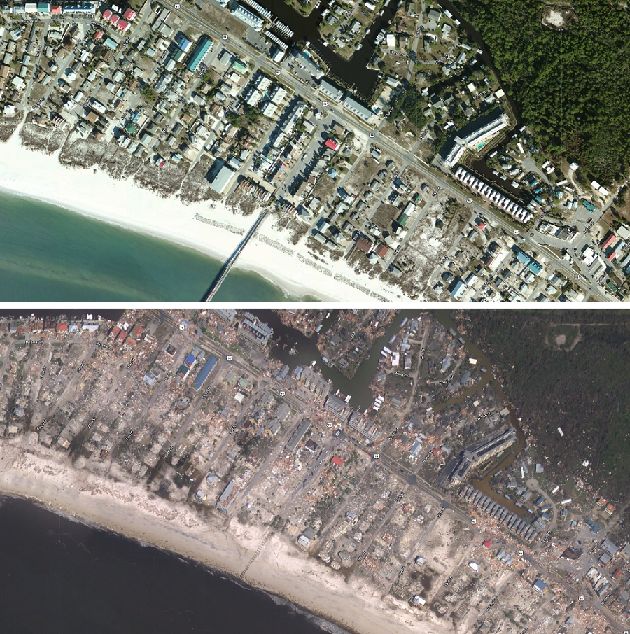
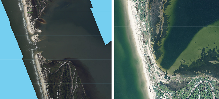
NOAA has made available imagery that shows the extent of catastrophic destruction around Florida’s panhandle from Hurricane Michael. By allowing the user to toggle imagery captured prior to Hurricane Michael’s arrival to imagery captured after, one can see not only how most structures were destroyed at the point of impact, but how the terrain has been altered too. The before and after imagery shows the extensive destruction that occurred in Panama City, even far from the coast. And it illustrates how much of Mexico Beach was erased from the map. Structures weren’t the only thing erased: the imagery also shows how the coastline was altered, replacing what was once land and roads with the Gulf of Mexico.


The Cape San Blas Road no longer exists; it and the barrier island it sat on were erased by Hurricane Michael. Image: NOAA

This imagery was acquired by the NOAA Remote Sensing Division to support NOAA homeland security and emergency response requirements. In addition, it will be used for ongoing research efforts for testing and developing standards for airborne digital imagery. Individual images have been combined into a larger mosaic and tiled for distribution. The approximate ground sample distance (GSD) for each pixel is ~25 cm / zoom level 19.

Images from the coast from  Fort Morgan at the Florida/Alabama border east to Marsh Island south and west of Tallahassee are available for viewing. The entire city of Panama City is also available for viewing.

The stunning image can be viewed and downloaded for free at this link: https://storms.ngs.noaa.gov/storms/michael/index.html#9/30.0085/-85.6549

Primary Sidebar

Sponsored Ad

Search

Latest News

  • Light Snow Showers Likely in Mid Atlantic to Kick-Off February
  • Mega Tsunami that Wiped Out Dinosaurs Simulated by International Experts
  • Heavy Rain and Snow Helped, but Drought Persists in West
  • Today Marks 37th Anniversary of Space Shuttle Tragedy
  • While East Coast Snow Drought Continues, New Winter Storm Brings Heavy Snow to Hawaii
  • Weather Satellites and their SARSAT Technology Saved Hundreds of Lives in 2022
  • Snow Drought Persists in Philadelphia, New York City, New Jersey, & Surrounding Areas
  • Earthquakes Rattle Los Angeles Area
About | Careers | Contact | Contests
Terms | Privacy | Ad Choices
Weatherboy is a (R) Registered Trademark of isarithm LLC, All Rights Reserved.
All content herein is Copyright by Isarithm LLC 1997-2022