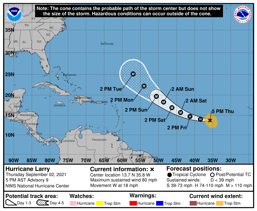
Hurricane Larry, spinning about in the central Atlantic Ocean, is likely to become a major hurricane soon, according to meteorologists with the National Hurricane Center (NHC) in Miami, Florida.
As of the latest advisory from the NHC, Hurricane Larry was located near 13.7N 35.8W which is about 765 miles west of the southernmost Cabo Verde Islands. Maximum sustained winds are 80 mph, making it a Category 1 hurricane on the Saffir-Simpson hurricane wind scale for now. While minimum central pressure is around 985 mb or 29.99″, the storm is moving due west at 18 mph.
According to the NHC, a gradual turn towards the west-northwest with a decrease in forward speed is expected over the next few days. A turn to the northwest is then expected by early next week. While maximum sustained winds are near 80 mph with higher gusts now, significant to possibly rapid intensification is forecast during the next couple of days, and Larry is expected to become a major hurricane tomorrow night.
For now, hurricane-force winds extend outward up to 25 miles from the center and tropical-storm-force winds extend outward up to 160 miles.
There are no tropical storm or hurricane watches up for any land mass at this time. Larry is not expected to make any landfall over the next five days.
Larry could become a record breaker. Only 3 other Atlantic seasons on record have had 3 hurricanes with max winds of 125+ mph by 4 September: 1933, 2005 and 2008. Larry is also the 5th hurricane of 2021 Atlantic season to date; 6 other years in satellite era (1966 onwards) have had 5+ Atlantic hurricanes by 2 September: 1966, 1995, 1996, 2004, 2005, 2012.
The 2021 Atlantic Hurricane Season runs through to the end of November.