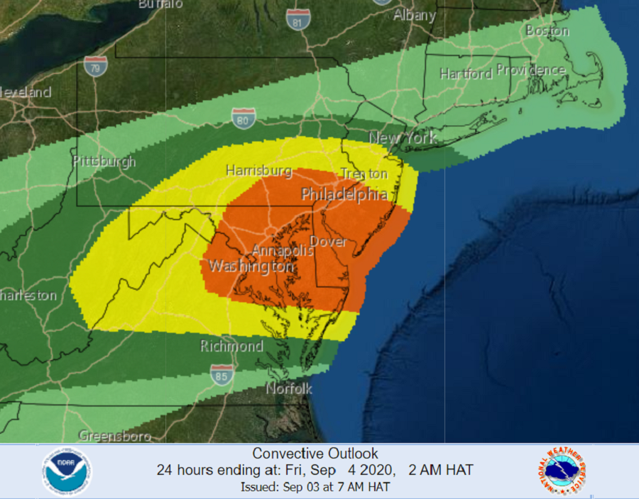
The National Weather Service’s Storm Prediction Center is warning of a possible severe weather outbreak that is forecast to unfold across portions of the Mid Atlantic later this afternoon, with an elevated threat of damaging winds and isolated tornadoes too. The greatest threat of tornadoes is across portions of southern New Jersey, Delaware, southeastern Pennsylvania, and eastern Maryland. Due to this threat, the National Weather Service is expecting to issue a Tornado Watch for this area within the next hour or two.
Right now, a broad area of shower activity extends from the Ohio Valley into Pennsylvania and New York amid a belt of strong mid-level flow. Areas south and east of this activity have slowly destabilized through the day with temperatures now in the upper 80s to low 90s in northern Virginia, eastern Maryland, and Delaware. In addition, the boundary layer is very moist with dewpoints in the mid to upper 70s. Due to these factors, ingredients are ripe for severe thunderstorm development later this afternoon. The National Weather Service is expecting a few strong storms to develop ahead of a shortwave moving out of West Virginia.
The Storm Prediction Center’s Convective Outlook shows that storms will likely become supercellular. Once this overspreads northern Virginia, Maryland, and Pennsylvania in a few hours, the damaging wind threat will increase and low-level shear will increase which should increase the tornado threat. The best tornado threat will likely be across northern Virginia, southern Maryland, and far southern Pennsylvania where there has been less mixing and surface winds remain southerly or south-southeasterly.
Due to these factors, the National Weather Service says “a tornado watch will likely be needed in the next hour or two as storm coverage and intensity increases.”
While not everyone will see a tornado or even a thunderstorm, thunderstorms developing in this region can quickly become severe. Severe thunderstorms by definition have strong, damaging wind gusts in excess of 57 mph, tornadoes, and/or large hail 1″ in diameter or greater. Today’s most likely severe weather elements expected in these storms are damaging winds and isolated tornadoes.
Beyond damaging winds and tornadoes, isolated flash flooding is possible in heavier downpours. Even without the winds and flood threat, lightning from even distant thunderstorms can be dangerous. The National Weather Service cautions that if thunder is close enough to be heard, lightning is close enough to kill.
The greatest threat of tornadic cells will be between 4pm and 7pm this evening.
Once the storms exit the Mid Atlantic, conditions will quiet down this evening, with fair weather returning to most of the region tomorrow as high pressure returns.