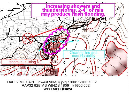
The National Weather Service’s Weather Prediction Center is warning people in New Jersey, Delaware, and Maryland this afternoon of the threat of flash-flood-producing showers and storms today. In a special update released moments ago, they say, “Showers and thunderstorms developing in a region of clear sky and enhanced instability will increase in coverage and train northeast through the afternoon. 2-4″ of rainfall in a short period of time will have the potential to produce flash flooding.” Lingering moisture from former Tropical Storm Gordon has saturated the atmosphere, setting the stage for a flood problem.
Technically, a shortwave moving across West Virginia is forecast to progress northeast towards Long Island into the evening hours today. This feature will combine with the approach of a jetstream lifting into New England to enhance rainfall activity in this portion of the Mid Atlantic. The increasing warm sector in this set-up will be favorable for thunderstorm development as surface dewpoints in the low 70s combined with a saturated, precipitation-ready airmass creates an environment favorable for heavy rainfall.
An analysis by the National Weather Service shows that training of thunderstorms is likely. Training is when thunderstorm cells flare up and travel over the same area repeatedly, soaking specific localized areas and increasing the flood threat.
High-resolution computer forecast guidance is in good agreement that a flood situation will occur here. 2-4″ of rain may fall in a very short period of time. According to Flash Flood Guidance, it would only take 2-3″ within a 3 hour period to create flood problems in this region. With rainfall rates approaching 2″/hour in this area, flash flooding is possible, especially in urban areas.
