
A magnitude 3.4 earthquake shook a remote stretch of northern Alaska on Thursday, the U.S. Geological Survey said. It was the strongest earthquake recorded within about 60 miles of the epicenter since at least Oct. 1.
The quake struck at 19:18:38 UTC on Nov. 12, which is 10:18 a.m. Alaska Standard Time and 1:18 p.m. CST. The USGS placed the epicenter 54 kilometers, or about 34 miles, north of Kobuk, a small village in northwestern Alaska. The agency’s regional label for the location is “northern Alaska.”
The earthquake was shallow, at a depth of about 2.2 kilometers, or about 1.4 miles, according to the USGS event page. The magnitude was calculated as a local magnitude, and the solution had been reviewed by a seismic analyst. The Alaska Earthquake Center, based at the University of Alaska Fairbanks, is the authoritative network for the location.
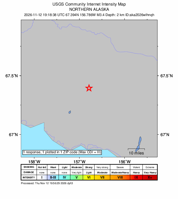
The USGS located the epicenter at 67.394 degrees north latitude and 156.786 degrees west longitude. That places it roughly 57 miles north of the Arctic Circle, in the remote country north of the Kobuk River.
Felt Report But No Sign of Damage
One person submitted a report through the USGS “Did You Feel It?” system, which collects reports from the public about what they experienced during an earthquake. The resulting community intensity map, which the USGS processed about 38 minutes after the earthquake, shows a maximum intensity of III. On the scale used on the map, intensities II and III are labeled “weak” shaking, with no damage expected.
The USGS event page did not include a ShakeMap or a PAGER estimate of potential losses, products the agency issues for more significant earthquakes. Nothing on the event page indicated damage or injuries.
The epicenter lies in sparsely populated terrain. The USGS nearby-places listing for the quake shows Kobuk, with a population of 158, as the closest community. Fairbanks, the nearest large city, is about 310 miles to the east-southeast, according to the same listing.
A magnitude 3 earthquake can be noticeable when it is shallow. “A magnitude 3 earthquake, if it’s shallow, can generate enough shaking to make objects sway,” the Alaska Earthquake Center wrote in its review of 2025 seismic activity.
Busy Month of Small Quakes
The Thursday quake was the largest of 11 earthquakes the USGS catalog lists within 100 kilometers, or about 62 miles, of the epicenter since Oct. 1. Most of the others were small, between magnitude 1.4 and 2.0.
The previous largest events in that window were a magnitude 2.8 earthquake on Oct. 4, about 39 kilometers north-northeast of Ambler, and a magnitude 2.7 on Oct. 7, about 32 kilometers north of Kobuk. A magnitude 2.0 earthquake was recorded on Nov. 3 about 77 kilometers east of Kobuk.
The USGS catalog listed no other earthquakes within that radius after Thursday’s quake as of early Friday.

Region Has a History of Moderate Quakes
The area around the Kobuk River valley has produced moderate earthquakes before. The USGS catalog lists 75 earthquakes of magnitude 3 or greater within 100 kilometers of Thursday’s epicenter since Jan. 1, 2000.
The largest in the catalog within that radius since 1970 was a magnitude 5.4 earthquake on April 23, 1989, about 22 kilometers east-northeast of Kobuk. It was part of a cluster that year that also included magnitude 5.0 earthquakes on April 27 and Oct. 9 and two magnitude 4.5 earthquakes in late April, all within about 26 kilometers of Kobuk, according to the catalog.
Other notable earthquakes within that radius include a magnitude 5.1 on Feb. 6, 1986, about 116 kilometers north-northeast of Kobuk; a magnitude 5.0 on Oct. 14, 2018, about 98 kilometers northeast of Ambler; and a magnitude 4.8 on March 13, 2025, about 89 kilometers north-northeast of Ambler.
Thursday’s magnitude 3.4 earthquake was far smaller than those events. Each whole-number step on the magnitude scale represents a tenfold increase in measured wave amplitude and about 32 times more energy released, according to the USGS. By that measure, the 1989 magnitude 5.4 earthquake produced waves roughly 100 times larger than Thursday’s quake.
Part of Alaska’s Constant Shaking
Earthquakes are a near-constant part of life in Alaska. The Alaska Earthquake Center said its analysts generally process 35,000 to 55,000 seismic events each year.
The center said the number of seismic stations in Alaska grew significantly in 2016, improving data quality and coverage and allowing it to detect more and smaller events. Large earthquakes can also swell the annual count, because their aftershocks can add tens of thousands of events to the catalog, the center said. It moved to a new system for receiving and analyzing earthquake data in November 2025.
The center said Alaska averages close to 2,000 seismic events above magnitude 3 each year, and about 200 events a year are reported felt by at least two people somewhere in the state. Alaska also averages 50 to 75 earthquakes above magnitude 5 per year, the center said, describing those as significant enough to cause major damage in other parts of the world.
Those totals put Thursday’s quake in perspective. Magnitude 3 earthquakes happen often statewide, but in the area around Kobuk, most of the events recorded since October have been magnitude 2 or smaller, according to the USGS catalog.
Other U.S. Earthquakes in the Past Day
The Kobuk earthquake was one of several modest earthquakes recorded in the United States from Thursday morning to early Friday, none of them larger than magnitude 3.5, according to the USGS.
A magnitude 3.5 earthquake struck at 9:27 p.m. CST Thursday about 88 kilometers south-southeast of King Cove, south of the Alaska Peninsula. No felt reports were listed for that event. A magnitude 3.3 earthquake struck at 3:47 a.m. CST Friday about 10 kilometers east-southeast of Nikiski on the Kenai Peninsula, at a depth of about 61 kilometers, and one person reported feeling it. That event had not yet been reviewed by an analyst as of early Friday.
In the Lower 48, a magnitude 3.0 earthquake struck at 11:18 a.m. CST Thursday about 3 kilometers north-northwest of Little America, Wyoming, and drew one felt report. A magnitude 2.6 earthquake was recorded at 1:40 p.m. CST Thursday about 1 kilometer east-northeast of Aromas, California.
