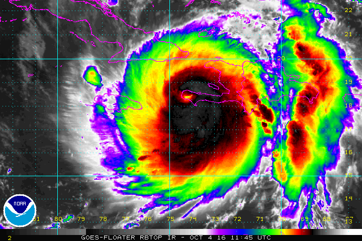
Major Hurricane Matthew made landfall this morning on the coast of Haiti at approximately 7am ET. The major hurricane, with maximum sustained winds of 145mph, struck land near Les Anglais in Western Haiti. As of 8am, the eye of Hurricane Matthew was located inland Haiti near latitude 18.4 North, longitude 74.2 West. The hurricane is moving toward the north near 9 mph and this general motion is expected to continue today. On this track the eye of Matthew will be back over water in the Gulf of Gonave in the next hour or so, and then move over the Windward Passage later this morning. A turn toward the north-northwest is expected by Wednesday, followed by a northwest turn Wednesday night. On the forecast track, the eye of Matthew will move near eastern Cuba later today, and move near or over portions of the southeastern and central Bahamas tonight and Wednesday, and approach the northwestern Bahamas Wednesday night
Maximum sustained winds remain near 145 mph with higher gusts. Matthew is a category 4 hurricane on the Saffir- Simpson Hurricane Wind Scale. Some fluctuations in intensity are possible during the next couple of days, but Matthew is expected to remain a powerful hurricane through at least Wednesday night. Hurricane-force winds extend outward up to 40 miles from the center and tropical-storm-force winds extend outward up to 185 miles. The estimated minimum central pressure is 934 mb (27.58 inches).
Residents in Hurricane Warned Cuba and Bahamas should brace for impact: preparations there to protect life and property should be complete. Further north and west, residents of Florida, Georgia, South Carolina, and North Carolina should begin acting on their Hurricane Action Plans. Preparations there should pick up today so that you’re ready for impacts as early as later tomorrow. Further up the Mid Atlantic and New England coast, residents there should closely monitor the future progress of this storm; impacts from Matthew may be felt there later in the week / next weekend.
It is still too soon to say with certainty whether Hurricane Matthew will make landfall on the US coast. However, the storm should be close enough to the cost to create wind damage, storm surge flooding, and flooding from heavy tropical downpours. Isolated tornadoes are also possible along the southeast coast later Wednesday through Friday.
For more on this storm, visit our Hurricane and Tropical Weather Page here: https://weatherboy.com/hurricanes-tropical-weather/
