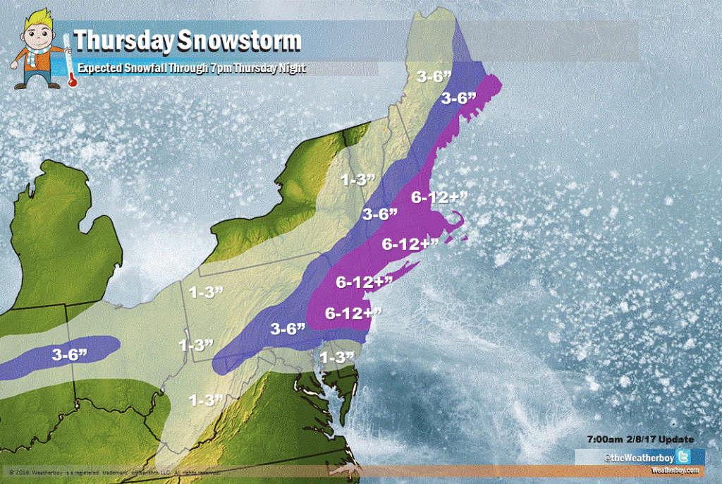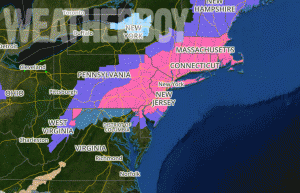

A major winter storm is expected on Thursday with a large area of 6-12″+ of snow expected. The National Weather Service has issued Winter Storm Warnings for all of Connecticut, Rhode Island, Massachusetts, most of New Jersey, southeastern New York including New York City and all of Long Island, northern Delaware, extreme northeastern Maryland, and eastern and southeastern Pennsylvania. It is this area where snow will be heaviest tomorrow.
Despite near-record and record-breaking warmth today in portions of the Mid Atlantic, a potent storm system will bring much colder air and heavy snow to a part of the country that hasn’t seen much snow yet this winter. A cold front will settle over the central Mid Atlantic today. Low pressure will develop along this front and track across the region later tonight, strengthening quickly as it tracks northeastwards towards Cape Cod Thursday afternoon. High pressure will build in Friday, giving residents the opportunity to dig out of Thursday’s storm.
In the Winter Storm Warning areas, Thursday will be rough, with the period from 6am to 1pm the worst. During the peak of the storm, snowfall rates may near 1-2″/hour, creating white-out conditions. Thunderstorms with heavy snow are also possible in eastern Pennsylvania, all of New Jersey, the New York City metropolitan area, Long Island, Connecticut, Rhode Island, and the eastern half of Massachusetts. Remember: when thunder roars, head indoors; lightning can kill in any season, even when snow is falling. Winds will be gusty; north winds of 15-25 mph will feature occasional gusts 25-40mph, with highest gusts on exposed coastal areas. Near-blizzard conditions are possible at times, especially over the Jersey Shore at and north of Long Beach Island, Long Island, and coastal Connecticut, Rhode Island, and Massachusetts. The combination of heavy, wet snow and gusty winds could stress power lines and tree branches, leading to some breaks. As such, isolated power outages are possible in the Winter Storm Warning areas.
Our latest snowfall map reflects some changes from the initial map issued yesterday. We now believe snow will accumulate a bit further south than initially expected; we also believe this system’s precipitation shield will hug the New England coast, preventing heavier amounts from reaching far inland. We initially thought someone milder conditions would keep snow totals down around Cape Cod and surrounding islands; we no longer believe that will be the case and expect heavy snow to reach the coast there.
The heaviest snow is expected on and around the I-95 corridor from the Philadelphia area north and east through the northern half of New Jersey, the entire New York City metropolitan area, all of Long Island, all of Connecticut and Rhode Island, and much of Massachusetts. In this area, a general 6-12″ heavy wet snowfall is expected with some isolated pockets of 12-15″ possible. The greatest threat of a foot or more of snow is over northern New Jersey, southeastern New York, Long Island, Connecticut, and eastern Massachusetts.
A moderate snowfall of 3-6″ is expected along and north of the Atlantic City Expressway in New Jersey, northern Delaware, portions of northern Maryland, and the south-eastern half of Pennsylvania. 3-6″ is also expected across central Indiana and west central Ohio. While 6-12″ is possible at the New England Coast, an area of 3-6″ will extend inland into southern Vermont, central New Hampshire, and eastern Maine.
A lighter, albeit slushy 1-3″ is expected for southern New Jersey including Cape May County. 1-3″ is also expected across the northern two-thirds of Delaware, northern Maryland, West Virginia, and extreme north central Virginia. A slushy inch or two is possible for Washington, DC and Baltimore, MD, especially on non-paved surfaces there; heavier amounts will accumulate just north of Washington, DC and Baltimore, MD.
Travel will become extremely difficult along the I-95 corridor tomorrow, especially from Philadelphia, PA to Boston, MA. In this area, it is suggested that people avoid travel during the period that is typically the morning rush hour. Air travel will also be challenging; expect significant impacts at PHL, EWR, TTN, BDL, ISP, JFK, LGA, BDL, PVD, and BOS airports. As always, contact your carrier for flight details prior to heading to the airport. Many airlines have issued weather waivers to passengers which will waive change/cancellation fees due to the storm.