While the calendar says we’ve entered the back half of March, Old Man Winter is lingering around: another snowstorm is expected to impact the Mid Atlantic in the coming days. It is also evident that another storm will bring more snow to the Mid Atlantic and Northeast after this next storm too. Extended forecast guidance is also suggesting this storm track and pattern supporting late-season east coast snowstorms could linger into the first week of April.
The storm system responsible for the heavy snow is actually a two-part system; the first part is Monday night into Tuesday while the second part is Tuesday night into Wednesday. This is an extraordinarily complex storm set-up, with multiple waves of low pressure impacting the Mid Atlantic region over a prolonged period of time.
The first part begins on Monday. A primary low west of the central Appalachians is forecast to transfers its energy to a coastal low that develops near Norfolk, Virginia on Monday. With the upper air pattern relative flat, the low should quickly progress to the east-northeast and out to sea. Cyclonic flow ahead of this low will induce strong isentropic lift along and north of the frontal boundary, which will help expand precipitation northeast into the DelMarVa, southeastern Pennsylvania, and southern New Jersey Monday night. With drier air originating over southeastern Canada and draining south into the northeastern United States, there will be an extremely sharp cut-off to accumulating snow on the north side of this system.
The second part begins Tuesday night after a lull in activity on Tuesday during the day and early evening. While the initial system is departing the coast, a wave of low pressure developing on the lee side of the southern Appalachians will deepen as it moves off the coast somewhere near the South Carolina / North Carolina coastal border. It appears this second part will phase the southern and northern stream shortwave disturbances, resulting in amplification of the upstream trough over the Ohio Valley. This system is forecast to intensify off the Mid Atlantic coast and head north and east. Unlike previous storms this month, this storm will likely impact the Mid Atlantic moreso than New England, although extreme southeastern New England should be brushed by this system before it departs the coast.
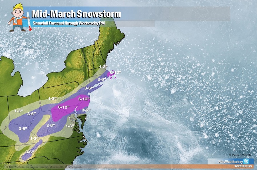
The snow will be heaviest south of I-276 in Pennsylvania and south of I-195 in New Jersey. Up to a foot of snow could fall in this heavy snow area that extends south into Maryland and northern Delaware. Both Philadelphia, PA and Baltimore, MD are included in this heavy band of 6-12″ of snow. New York City is forecast to be just north of the heavy snow area; there, about 3″ is expected. Washington, DC is expected to be just south of the heavy snow area too, with only 3″ forecast for the Nation’s Capital. 6-12″ is also possible over extreme southeastern Massachusetts, with most of that falling later Wednesday. With that cold, dry air draining down from Canada, there will be an extremely sharp cut-off of snow on the northern side of this system. As an example, northwestern New Jersey may only see an inch or two of snow while southwestern New Jersey may see a foot of snow.
With another round of heavy snow expected, there is a potential for extensive power outages once again given the damage left behind from the previous nor’easters this month. There could also be wind issues, especially on Wednesday, as that second part intensifies; the worst winds would be over southeastern Pennsylvania and central and southern New Jersey. Coastal flooding could be a concern; however, only minor to moderate coastal flooding is expected at times of high tide.
While this system impacts the region, attention will turn to the next winter storm. High pressure will build in behind the first event later Thursday into Friday. Cold air, roughly 5-10 degrees below normal, and dry conditions are expected to return to the Northeast and Mid Atlantic. A new area of low pressure will enter the area over the weekend, setting the stage for another round of significant accumulating snow in the northeast.
