A computer model projection showing a Valentine’s Day snowstorm impacting portions of the Mid Atlantic is unlikely to come to fruition. In recent days, the American GFS forecast model has been suggesting that a potent snowstorm would blossom in an area that has lacked big snowstorms all season. However, other models disagree with such an assessment and even the GFS is flip-flopping on potential scenarios.
The GFS and ECMWF are among many computer models meteorologists use to assist in weather forecasting. While meteorologists have many tools at their disposal to create weather forecasts, two primary global forecast models they do use are the ECMWF from Europe and the GFS from the United States. While the models share a lot of the same initial data, they differ with how they digest that data and compute possible outcomes. One is better than the other in some scenarios, while the opposite is true in others. No model is “right” all the time. Beyond the ECMWF and GFS models, there are numerous other models from other countries, other academic institutions, and private industry that are also considered when making a forecast.
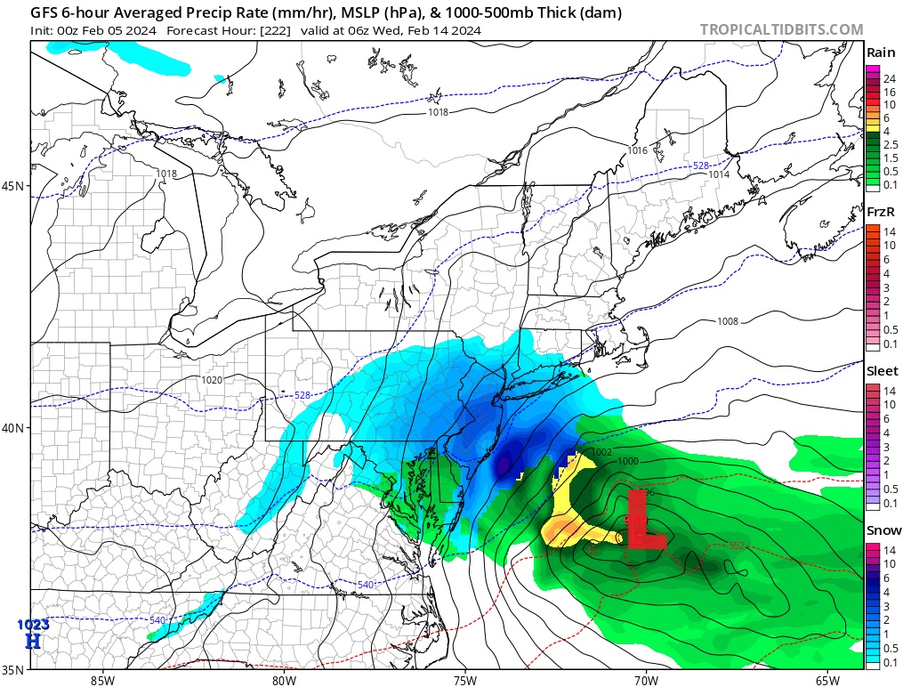
Some model runs of the GFS, such as last night’s overnight run, show an area of low pressure developing off the Mid Atlantic coast, producing snow on its backside across portions of Pennsylvania, Maryland, New York, Virginia, Delaware, and New Jersey. If this solution were to verify, a widespread 6-12″ snowfall would occur here.
However, the more recent run of the GFS model shows a completely different solution, with a weak disturbance and a light mix of rain and snow moving through the Mid Atlantic. While it shows some accumulating snow, it maxes forecast amounts to 2-4″ and constrains such accumulations to the higher terrain near the West Virginia / Maryland/ Pennsylvania border. Because this model run is so different from the previous run, there is little confidence in any solution being the “right” one.
The ECMWF has a very different forecast from the GFS. Rather than the jet stream moving from west to east or even northwest to southeast over the Mid Atlantic, the ECMWF reflects a jetstream surging north to the Great Lakes, bringing milder air to the coastal plain while producing a significant area of low pressure over the Great Lakes. As such, it produced a stronger storm than the GFS but in a totally different place with a totally different outcome. While the GFS calls for cold and snow, the ECMWF solution would suggest above-normal temperatures and only rain, not only in the Mid Atlantic, but far into New England too.
With the GFS and ECMWF at odds with each other, it’s likely neither’s forecast are completely right; it is more likely a solution somewhere in between is more probably. However, with the performance of the ECMWF somewhat better than the GFS over recent weeks in the current weather pattern, the outcome is likely to be closer to the European model than the American one.
