
A moderate earthquake rocked western Upstate New York today not far from Buffalo; it was the strongest earthquake to strike in decades. The earthquake struck at 6:15 am this morning from a depth of 1.86 miles; USGS says it was a magnitude 3.8 seismic event.
“It felt like a car hit my house in Buffalo. I jumped out of bed,” Erie County Executive Mark Poloncarz Tweeted after experiencing the quake.
Since 1983, there have been 24 earthquakes above magnitude 2.5 in the West Seneca region, with Monday’s being the largest so far in the area. A 3.8 magnitude earthquake struck in this region in 1999.
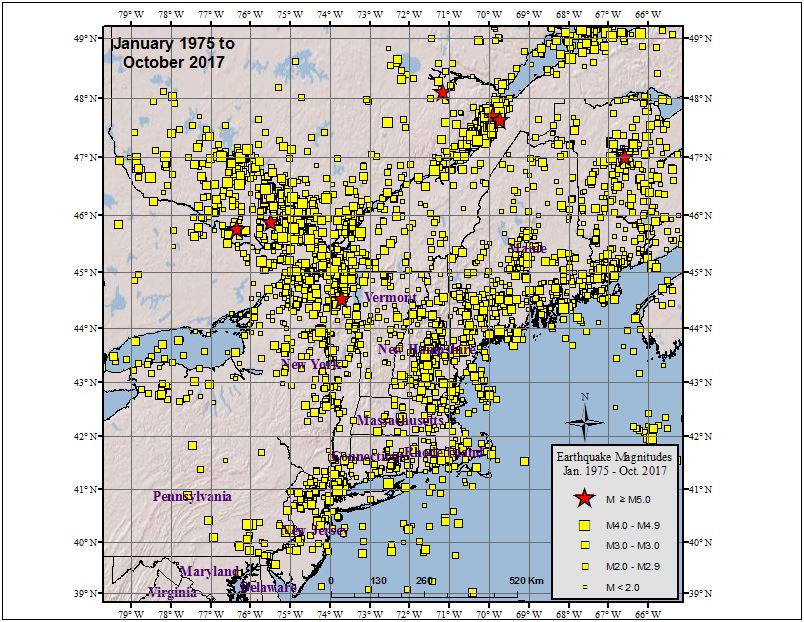
According to the Northeast States Emergency Consortium (NESEC), New York is a state with a very long history of earthquake activity that has touched all parts of the state. Since the first earthquake that was recorded in December 19, 1737, New York has had over 550 earthquakes centered within its state boundaries through 2016. It also has experienced strong ground shaking from earthquakes centered in nearby U.S. states and Canadian provinces. Most of the earthquakes in New York have taken place in the greater New York City area, in the Adirondack Mountains region, and in the western part of the state.
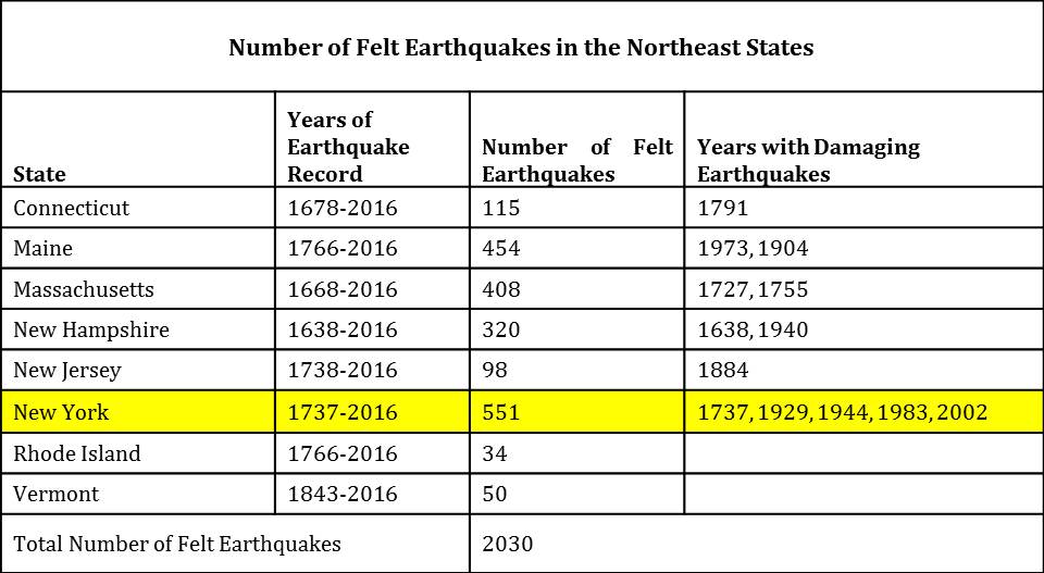
While many of the earthquakes to hit New York are weak or mild like today’s, some have been damaging. Of the 551 earthquakes recorded between 1737 and 2016, 5 were considered “damaging”: 1737, 1929, 1944, 1983, and 2002.
While most of New York’s earthquakes have been in the Upstate, New York City has also seen damaging earthquakes over the years. At about 10:30 pm on December 18, 1737, an earthquake with an unknown epicenter hit New York with an estimated magnitude of 5.2. That quake damaged some chimneys in the city. On August 10, 1884, another 5.2 earthquake struck; this quake cracked chimneys and plaster, broke windows, and objects were thrown from shelves throughout not only New York City, but surrounding towns in New York and New Jersey too. The shaking from the 1884 earthquake was felt as far west as Toledo, Ohio and as far east as Penobscot Bay, Maine. It was also reported felt by some in Baltimore, Maryland.
