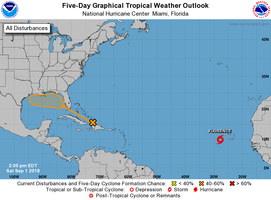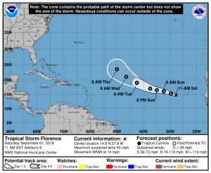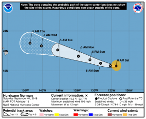
With the peak of hurricane season arriving, the activity in both the Atlantic and Pacific hurricane basins is picking up. Tropical Storm Norman has formed in the Atlantic while Hurricane Norman continues to spin about in the Pacific near Hurricane Miriam. Two additional tropical cyclones could form in the coming days: one near the Gulf Coast of Florida, the other well west of the coast of Mexico.
Of the bunch, the disturbance that could form near the Gulf Coast of Florida could be the biggest threat to the U.S. Cloudiness and showers over the Turks and Caicos Islands and the southeastern Bahamas have increased a little bit today. This activity is associated with a tropical wave interacting with an upper-level trough. This weather system is expected to spread westward across the remainder of the Bahamas this weekend, and move across southern Florida and into the eastern Gulf of Mexico by early next week. Surface pressures are not falling at this time, and development is not anticipated during the next day or two. However, according to the National Hurricane Center, environmental conditions are forecast to become a little more favorable for a surface low pressure area to form when the disturbance moves across the Gulf of Mexico during the early to middle part of next week. Some forecast guidance suggests a tropical storm could form here over time and impact the central Gulf coast. Whether that happens or not is not yet known, but it is likely that at the very least it’ll be very wet in the Gulf Coast region next week as this disturbance moves in.

While eyes are on the potential Gulf system, meteorologists are also tracking the Atlantic’s latest named storm: Tropical Storm Florence. In the last advisory, the center of Tropical Storm Florence was located near latitude 14.8 North, longitude 27.8 West. Florence is moving toward the west-northwest near 14 mph, and this general motion is expected to continue through Tuesday. On the forecast track, Florence will continue to move toward the open eastern Atlantic. Maximum sustained winds have increased to near 45 mph with higher gusts. Some strengthening is forecast during the next 48 hours. Tropical-storm-force winds extend outward up to 35 miles from the center. The estimated minimum central pressure is 1003 mb or 29.62 inches. Florence is not expected to impact land as it tracks around the central Atlantic Ocean.
Elsewhere in the Atlantic, no tropical cyclone formation is expected in the next five days. In the Pacific though, one or two new systems are expected in the next five days.
The National Hurricane Center (NHC) is issuing advisories on Hurricane Norman, located more than 1000 miles west-southwest of the southern tip of the Baja California peninsula, and on Tropical Depression Seventeen-E, located almost 500 miles southwest of Manzanillo, Mexico. Both of these systems may impact the weather in Hawaii over time. Meanwhile, another area of low pressure is expected to form well south of the southwestern coast of Mexico in a few days. According to the NHC, some gradual development of this system is possible through the middle of next week. Beyond Norman, the next system to earn a name in the Eastern Pacific Hurricane Basin will be called Olivia.

Hurricane Norman has weakened to a Category 2 hurricane, but is still packing a punch over the open waters of the Pacific. In the latest update from the NHC, the center of Hurricane Norman was located near latitude 16.2 North, longitude 123.7 West. Norman is moving toward the west near 12 mph . A general westward to west-northwestward motion with an slight increase in forward speed is expected through early next week. On the forecast track, Norman will approach the central Pacific basin on Tuesday. Maximum sustained winds have decreased to near 105 mph with higher gusts. Little change in strength is expected today. Gradual weakening is forecast to begin on Sunday and continue through early next week. Hurricane-force winds extend outward up to 25 miles from the center and tropical-storm-force winds extend outward up to 105 miles. The estimated minimum central pressure is 970 mb or 28.65 inches.
While the official forecast track for Norman from the NHC brings the center of the system north and east of Hawaii’s Big Island over time, it may be close enough to bring heavy rain to portions of the Aloha State, with Maui and Hawaii having the greatest threat of rain. It is also possible that the center of Norman may pass even closer by Hawaii; there’s often large errors in forecast track more than five days out. As such, while there are better chances that Norman will miss Hawaii rather than hit it, people in Hawaii should continue to monitor changing forecasts and make sure their Hurricane Action Plan is in place and that their hurricane supplies are re-stocked if they were consumed during Hurricanes Hector or Lane.
One storm that won’t impact Hawaii is Hurricane Miriam. In the latest advisory from the Central Pacific Hurricane Center, the center of Hurricane Miriam was located near latitude 22.2 North, longitude 141.3 West. Miriam is moving toward the north near 12 mph and this motion is expected to become north-northwest through Sunday, then northwest Monday. On such a path, Miriam will pass safely away from Hawaii in the coming days. Maximum sustained winds are near 75 mph with higher gusts. Rapid weakening will occur today through Sunday and Miriam is forecast to become a post-tropical remnant low early Monday. For now, hurricane-force winds extend outward up to 25 miles from the center and tropical-storm-force winds extend outward up to 110 miles. The estimated minimum central pressure is 984 mb or 29.06 inches.