Soaking rains are returning to southern California for the balance of the week and while they are much needed, they’ll also be bringing multiple hazards to the region too. A new storm system will start to move into the West Coast late Wednesday
night into Thursday morning, producing heavy rain and higher-elevation snow over parts of the Pacific Northwest and California. But over southern California where large parcels suffer from burn scars from recent fires, those rains could lead to debris flows, mudslides, and other landslides.
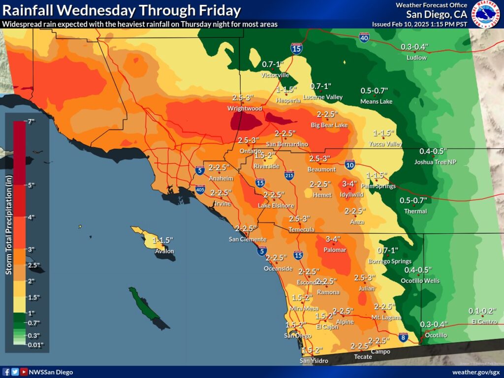
There will be increasing chances for precipitation for Wednesday and Wednesday night with rainfall from 0.25-0.50″ for coastal areas to 0.5-1″ locally in the highest terrain. The San Diego County mountains for tonight through Wednesday afternoon could see the most, with 1.5-2″ possible there. For Palomar Mountain, 1″ is expected.
The heaviest precipitation is expected for Thursday and Thursday night. For Orange and southwestern San Bernardino Counties, rainfall is expected to range from 1-1.5″ near the coast to 3-5″ along the coastal slopes of the San Bernardino County mountains with locally greater amounts. For San Diego County, rainfall is expected to range from 0.75-1.25″ around the coast to 2-3″ in the mountains with locally greater amounts.
Up the coast, rainfall amounts of 1.5-3″ will be common at lower elevations and 3-6″ across the mountains and foothills with almost twice these totals for portions of San Luis Obispo county.
A snow level near 4,500 to 5,000 feet today will rise from around 4,500 feet Wednesday morning, to 6,500 feet for late Wednesday afternoon, to 7,500 to 8,000 feet for late Wednesday night and Thursday.
What will start out as an Atmospheric River over the middle of the state will morph into a more classic winter storm with a warm and cold front as the upper low moves to the south and tilts the storm system into a southwest to northeast orientation.
In addition to heavy rain and elevation snow, there could be damaging winds too. Around the Los Angeles region, warning level wind gusts greater than 60 mph will likely affect the higher elevations during the time of the cold front passage as the storm pushes east.
