The National Hurricane Center is monitoring three areas of concern across the Atlantic Hurricane Basin, with the most substantial future threat of the three near the Gulf of Mexico. The National Hurricane Center (NHC) outlined the three areas of concern in their latest Tropical Outlook product.
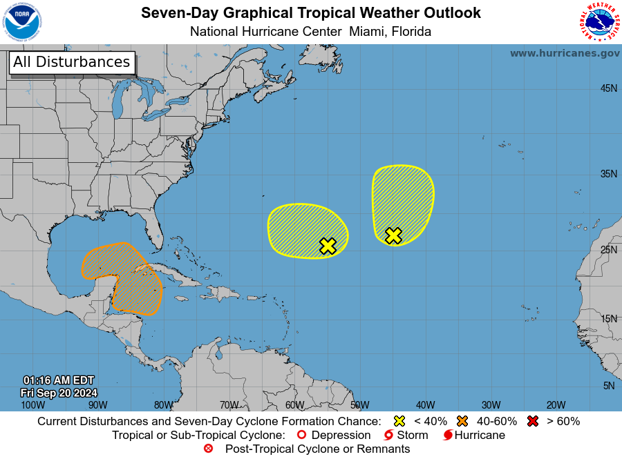
The first area deals with the remnants of former Tropical Storm Gordon. Located over the Central Subtropical Atlantic, what’s left of the storm is now only an area of showers and thunderstorms. The NHC says some development of this system is possible during the next couple of days while it moves northward or north-northeastward, but it will be of no threat to any landmass if it does. For now, there’s only a 30% chance that a tropical cyclone will re-form here.
The second area of concern over the Central and Western Subtropical Atlantic is an area of low pressure located about 750 miles southeast of Bermuda. According to the NHC, this shower and storm activity has become a little more concentrated over the past several hours. The NHC adds that environmental conditions appear only marginally conducive, but some development of this system is possible while it meanders over the open waters of the central or western Subtropical Atlantic though early next week. As with the first system, there’s only a 30% chance that a system will develop here.
The third area of concern has the highest odds of developing; it also has the greatest risk to eventually impacting the United States. According to the NHC, a broad area of low pressure could form by early next week over the northwestern Caribbean Sea. Thereafter, gradual development of this system is possible, and a tropical depression could form as the system moves slowly to the north or northwest over the northwestern Caribbean Sea and into the southern Gulf of Mexico through the middle part of next week. Some global forecast models are very bullish with this system, eventually bringing it to land along the Gulf Coast as a hurricane before the end of next week. It is still too soon to say with any confidence of whether or not that will happen. And the NHC only believes there’s a 40% chance of tropical cyclone formation there anyway for the next 7 days.
Elsewhere the NHC expects no other tropical cyclone formation anywhere in the basin over the next 7 days.
The 2024 Atlantic Hurricane Season runs through to the end of November.
