The National Hurricane Center (NHC) today is busy tracking a total of 4 areas of concern including newly formed Tropical Storm Kenneth in the Pacific and Hurricane Nigel in the Atlantic. The additional two systems are disturbances located near the southeast U.S. east coast which has a low chance of developing and a system in the central Atlantic that has a high chance of developing.
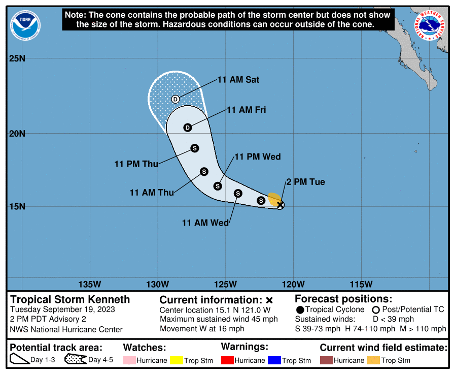
Tropical Storm Kenneth is roughly 2,265 miles east-southeast of Hilo, Hawaii with winds of 45 mph. Kenneth became the 11th named storm of the 2023 Eastern North Pacific Hurricane Season a short time ago. It is moving to the west at 16 mph with a minimum central pressure of 29.65″.
Kenneth is forecast to be a short lived system of little consequence. A west-northwestward motion at a slower forward speed is expected by the NHC during the next day or two, with a turn to the northwest or north-northwest is expected on Thursday. While some strengthening is forecast during the next day or so, a weakening trend is forecast to begin on Thursday. Kenneth isn’t expected to make any direct impacts to Hawaiian weather over time.
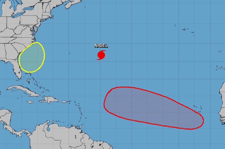
A system getting more attention is a disturbance developing along the southeast coast of the U.S.. According to the NHC, a non-tropical area of low pressure is expected to form east of the Florida peninsula late this week. This system could acquire some subtropical or perhaps even tropical characteristics this weekend while it moves generally northward. Regardless of development, this low is likely to bring gusty winds, heavy rain, and high surf to portions of the Southeast and Mid-Atlantic United States late this week and into this weekend.
Computer forecast models, including the European ECMWF and the American GFS, do indicate a storm system gathering strength along the east coast before bringing wind-whipped heavy rains and gusty winds to portions of North Carolina, Virginia, Maryland, Delaware, and New Jersey. Because it is projected to be a slow-moving system, upwards of 3-5″ of rain could fall over New Jersey, Delaware, and eastern Maryland from it, which could prompt flooding concerns.
While this coastal system will likely impact the United States, it is very likely that Hurricane Nigel won’t. Nigel is currently a 100 mph hurricane located about 590 miles east of Bermuda. It is moving to the north-northwest at 14 mph with a minimum central pressure of 974 mb or 28.77″.
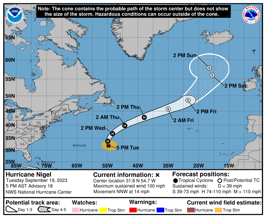
The NHC expects Nigel to turn toward the north tonight, followed by an acceleration toward the northeast through the rest of the week. While some additional strengthening is possible through early Wednesday, the NHC says weakening is expected on Thursday and Friday, when then the system is expected to become a strong post-tropical cyclone. While Nigel won’t impact any land mass, swells generated by it will affect Bermuda during the next couple of days. These swells are likely to cause life-threatening surf and rip current conditions.
The next system of concern is in the eastern Atlantic and the National Hurricane Center expects it to develop into a tropical cyclone in the coming days.
According to the NHC, a tropical wave is expected to move off the west coast of Africa by Wednesday. Environmental conditions are forecast to be conducive for gradual development of the wave thereafter, and a tropical depression is likely to form late this week or this weekend while the system moves generally westward at 10 to 15 mph across the eastern and central tropical Atlantic. Right now, the NHC believes there’s a 70% chance that a tropical cyclone will develop from this disturbance over the next 7 days.
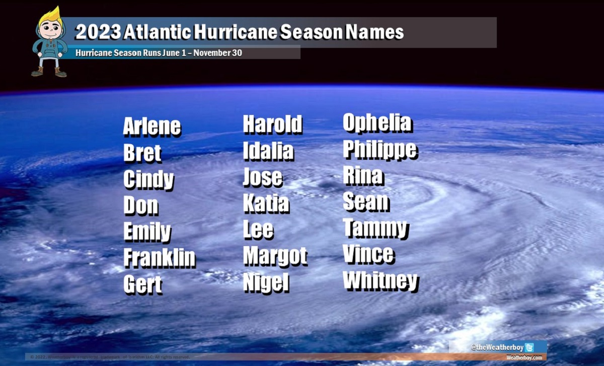
The next names up on the list of Atlantic Hurricane Season storms are Ophelia and Philippe. Beyond those two names, there are only 5 names left for the hurricane season which runs through the end of November. The remaining names are Rina, Sean, Tammy, Vince, and Whitney. If the list is exhausted, the NHC will pull from an additional list of alternate names, with the first of those being Adria.
