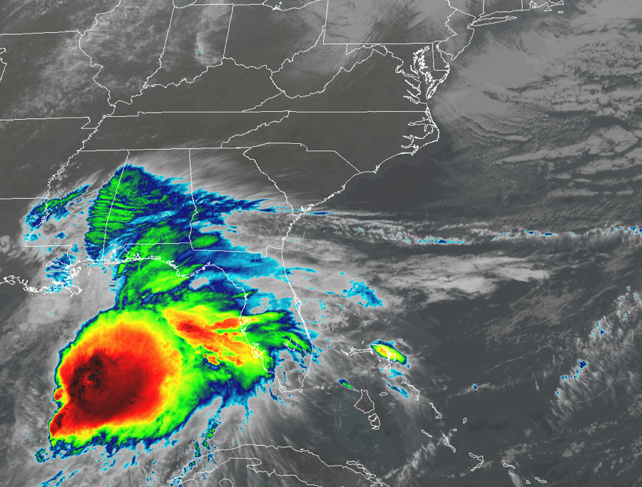
Tropical Storm Nestor has formed in the Gulf of Mexico; various warnings are up for the Gulf Coast and residents as far north as New York City on the East Coast should closely watch the future progress of this storm.
People in warning areas should rush their storm preparations to completion. A Tropical Storm Warning is in effect for the area from the Mississippi/Alabama border to Yankeetown, Florida and from Grand Isle, Louisiana to the Mouth of the Pearl River. A Storm Surge Warning is in effect for Indian Pass, Florida to Clearwater Beach, Florida. A Tropical Storm Warning means that tropical storm conditions are expected somewhere within the warning. A Storm Surge Warning means there is a danger of life-threatening inundation, from rising water moving inland from the coastline, in the indicated locations. This is a life-threatening situation; persons located within these areas should take all necessary actions to protect life and property from rising water and the potential for other dangerous conditions. The National Hurricane Center (NHC) urges people to promptly follow evacuation and other instructions from local officials.
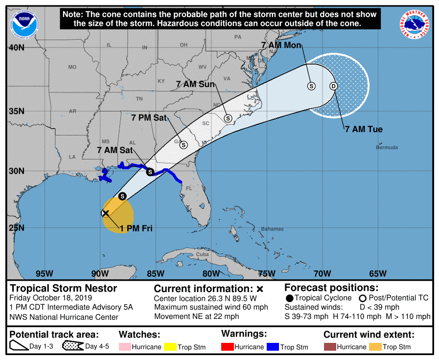
As of 2pm ET / 1pm CT, the center of Tropical Storm Nestor was located near latitude 26.3 North, longitude 89.5 West. Nestor is moving toward the northeast near 22 mph, and this general motion is expected to continue through Sunday, followed by a turn toward the east-northeast by early Monday. On the forecast track, the center of Nestor will approach the northern Gulf Coast later today and tonight and move inland across portions of the southeastern United States Saturday and Sunday as it becomes a post-tropical cyclone. Nestor is expected to move offshore of the coast of North Carolina into the western Atlantic by late Sunday.
Nestor is a solid tropical storm. Maximum sustained winds are near 60 mph with higher gusts. Some strengthening is expected later today, with weakening forecast after Nestor moves inland. Nestor is expected to lose tropical characteristics and become post-tropical on Saturday. Tropical-storm-force winds extend outward up to 175 miles, mainly to the northeast and east of the center. The estimated minimum central pressure is 1001 mb or 29.56 inches.
Numerous hazards will be impacting the U.S. soon: storm surge flooding, damaging winds, heavy rain, and tornadoes. A storm surge of 3-5′ is possible from Indian Pass, Florida to Chassahowitzka, Florida; a 2-4′ storm surge is possible from Chassahowitzka, Florida to Clearwater Beach, Florida. Tampa Bay could see a storm surge of 1-3′. Surge-related flooding depends on the relative timing of the surge and the tidal cycle, and can vary greatly over short distances. Tropical storm force wind conditions are expected to reach the coast within the warning area by later today and this evening, making outside preparations difficult or dangerous. Gale-force winds are likely along portions of the Atlantic coast of the southeastern United States by Saturday. Nestor is expected to produce total rainfall accumulations of 2 to 4 inches this weekend from the central Gulf Coast and northern and central Florida to the eastern Carolinas, with isolated maximum amounts of 6 inches. A tornado or two is possible tonight and early Saturday near the Florida Gulf Coast from the central panhandle to western parts of the Florida peninsula.
Over time, the storm will track north and east. Some computer forecast guidance is suggesting the storm may hug the coast a bit closer than others, and while the center of circulation should stay off-shore as it moves east of the Mid Atlantic Coast, some precipitation and gusty winds could reach as far north and west as Pennsylvania and New York. Because of this chance, residents from New York City and points south along the East Coast should closely monitor the progress of this storm this weekend.
