An area of low pressure, known in meteorological circles as a cyclone, is expected to explosively develop over or very near New Jersey in the coming days, setting the stage for more than a foot of snow to fall in time for Valentine’s Day. With many days of data needing to be analyzed and understood by meteorologists and the computer software they use to create forecast, it is too early to say with certainty how much snow will fall and where, but not too soon to say there’s high confidence that some large storm will form.
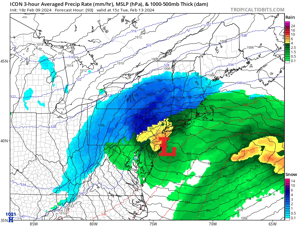
Early next week, low pressure will move into the Mid Atlantic as high pressure builds in from the north. In the midst of this squeeze play, the cyclone at the heart of the disturbance will be intensified as an upper trough follows behind it. As precipitation breaks out in the central and southern Mid Atlantic late Monday into early Tuesday, rain will fall. In the northern portions of the Mid Atlantic, rain and/or snow will fall, with the precipitation type changing over to all-snow for those on the northern portion of the storm track.
Where the storm track sets-up will help define not only where a rain/snow line will set-up, but how much snow will fall in areas where some kind of changeover is expected. Right now, it appears that dividing line will be along and north of I-80 and I-78 in New Jersey and Pennsylvania, with heavy snow likely in southern New York State and into south/central New England.
As cold air advection occurs on the backside of the storm, cold air wrapping around it will help change mixed precipitation or plain rain over to plain snow. How far south that change-over occurs and how much snow falls where a change-over does occur remains questionable, especially south of I-80 and I-78 into central New Jersey and the New York City and Philadelphia metro areas.
Right now, model guidance suggests the most significant accumulating snow will fall across the southern Poconos, northern New Jersey, southern Upstate New York, Connecticut, Massachussetts, and Rhode Island. The National Weather Service warns the significant snowfall area could extend to the geographic Fall Line west of the coastal plain in Pennsylvania and New Jersey. But east of there, including the I-95 corridor from New York City and points south and east, the chance for accumulating snow is small at this time.
According to the National Weather Service, the latest snow probabilities from their forecasting tools “indicate a 35 percent chance for 6 inches of snow or more in the 24 hour period ending 7pm Tuesday for Carbon, Monroe, and Sussex (NJ) counties.” They add that the tool also indicates “a 35 percent chance for 2 inches of snow or more in the 24 hour period ending 7pm Tuesday for areas down to the I-95 corridor, including Philadelphia and surrounding suburbs, extending towards coastal New Jersey.”
As the storm approaches and more data is reviewed, the forecast and the confidence in such a forecast will improve.
The National Weather Service generally issues Winter Storm Watches 12-48 hours prior to a storm; as such, watches may be issued as soon as later Sunday for a Tuesday storm.
While the forecast specifics are hazy, one thing is certain: the cyclone will quickly head off the northeast coast on Valentine’s Day, providing for fair, dry, and cold weather across the Northeast then. It’ll also provide fair weather for a dig-out of the snow, including the heavy snowfall areas, from the precipitation expected to fall the day and night before.
