• Skip to primary navigation
  • Skip to main content
  • Skip to primary sidebar

Weatherboy

Weatherboy Weather News, Maps, RADAR, Satellite, and Forecasts.

  • Local
  • Earth Science News
  • RADAR
  • Current Warnings
  • Satellite
  • Current Maps
  • Forecast Maps
  • Video

New Severe Weather Outbreak Marches East

by Weatherboy Team Meteorologist - April 17, 2019

The National Weather Service Storm Prediction Center has issued a Convective Outlook to show where the greatest risk for severe weather is today, left, tomorrow, middle, and Friday, right.  Image: weatherboy.com
The National Weather Service Storm Prediction Center has issued a Convective Outlook to show where the greatest risk for severe weather is today, left, tomorrow, middle, and Friday, right. Image: weatherboy.com


Yet another severe weather outbreak is forming in the middle of the United States and it is forecast to move east into the southeast and eventually the east coast by the end of the week. This outbreak comes on the heels of another significant one that impacted a large part of the country April 14-15. That event spawned numerous tornadoes and more than 300 reports of hail and wind damage.

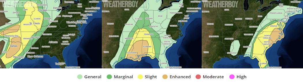
Today, the greatest threat for severe storms this afternoon and evening is from central Texas across the Dallas/Fort Worth Metroplex to southern Oklahoma, and from southern Kansas to the northern Texas Panhandle. Here, expect damaging hail, and a few severe gusts and tornadoes also are possible.


In addition to damaging winds, large hail, and the threat of tornadoes, thunderstorms will also create abundant lightning.

Severe thunderstorms are expected Thursday across the Lower and Middle Mississippi Valleys as well as across the Southeast and Tennessee Valley. Damaging winds and a few tornadoes are possible, especially from Louisiana into Mississippi.

Numerous thunderstorms are possible from the Mid-Atlantic States southward in Florida on Friday. Some of these storms will be capable of producing damaging wind gusts. A few tornadoes are also possible. According to the National Weather Service’s Storm Prediction Center, given the strong forcing for ascent and little to no convective inhibition, additional thunderstorm development is possible across the Carolinas and much of the mid-Atlantic as early as the late morning. Widespread thunderstorm coverage is anticipated with a generally messy convective mode. Bowing line segments capable of damaging wind gusts appear to be the primary severe threat although tornadoes will be possible as well, particularly in areas of slightly better low-level moisture and backed surface winds. Highest coverage of severe is currently expected from the northeast South Carolina coast into southeastern Virginia where the best overlap between favorable low-level moisture, southeasterly surface winds, and a strong low-level jet exists.

Primary Sidebar

Sponsored Ad

Search

Latest News

  • Overnight Earthquake Rattles Kentucky Southeast of Cincinnati, Ohio
  • Comet C/2025 K1 (Atlas) Splits Up While Interstellar Object 3I/Atlas Continues to Puzzle Scientists
  • Sun Launches Powerful X Class Solar Flare – Again!
  • After Violent 48 Hours, Earth’s Atmosphere Returns to Normal After Geomagnetic Storm
  • IMPACT! CME Arrives on Earth, Geomagnetic Storm Building; Expected to be SEVERE
  • SEVERE Geomagnetic Storm (G4) Now Expected November 12
  • Earth is Now Picking Up Radio Signals from 3I/Atlas Interstellar Object
  • Shocking New Images of 3I/Atlas Adds to Alien Spaceship Theory by Harvard Scientist
About | Careers | Contact | Contests
Terms | Privacy | Ad Choices
Weatherboy is a (R) Registered Trademark of isarithm LLC, All Rights Reserved.
All content herein is Copyright by Isarithm LLC 1997-2022

Insert/edit link

Enter the destination URL

Or link to existing content

    No search term specified. Showing recent items. Search or use up and down arrow keys to select an item.