Unfortunately for areas hit hard by tropical cyclones earlier this year and last, what’s left of Hurricane Nicholas is drifting along the central Gulf coastline, dumping very heavy rain in an area that doesn’t need any. While Nicholas is stuck on the Gulf Coast today, there’s hope the remnants will start to break up and move out in the coming days.
As of the latest update from the National Weather Service, the circulation associated with Nicholas was moving slowly to the north at only around 2 mph and unfortunately for those dealing with its heavy rain, this motion is expected to continue through Friday. The heaviest rainfall associated with the post-tropical low will continue to be well removed to the east of the circulation today. However, according to the National Weather Service, there is some chance for thunderstorm development closer to the cyclone center, and these thunderstorms could pose a risk of locally heavy rainfall, while additional thunderstorms continue to move northeast from the Gulf of Mexico across southeast Louisiana, southern Mississippi and Alabama, to the Florida Panhandle.
While what’s left of Nicholas continues to pack a punch with heavy rain, the same isn’t true of winds. Maximum sustained winds are near 25 mph with higher gusts making things breezy but not dangerous. The system is forecast to remain relatively weak through 48 hours.
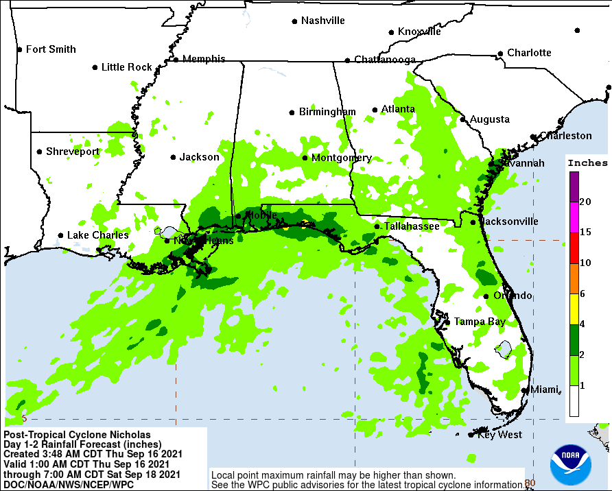
Overall, Nicholas is expected to produce additional rainfall of 2-4″ across the central Gulf coast Friday, with isolated amounts of 6″ possible. Flash flooding impacts, especially in urban areas, are possible across these regions. Widespread minor river flooding is expected, while scattered moderate river flooding is possible, across portions of southeastern Louisiana, southern Mississippi, southern Alabama, and the Florida Panhandle.
