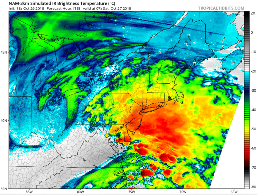
A potent nor’easter is due to pack an imminent punch to portions of the northeast, with New Jersey and New York in the crosshairs for the most severe weather conditions. Heavy rains, which could generate localized flash flooding, coastal flooding and beach erosion, and damaging winds are all possible as this nor’easter quickly moves up the northeast coast tonight into tomorrow.
While the center of the surface low won’t quite reach Delaware before sunrise tomorrow, significant impacts will be felt across the Mid Atlantic and southern New England beginning ahe coasts soon as later tonight.
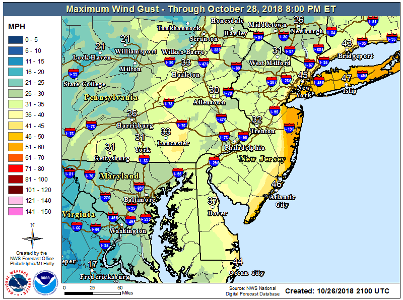
While rain is an issue, winds are a bigger concern. There will be a strong easterly low level jet on the north side of the low. the northern New Jersey shore has the highest risk for seeing these strong winds, with gusts up to 60 mph possible. Wind speeds should diminish considerably as you go further inland ; in far western Monmouth and Ocean counties, winds may barely get to wind advisory criteria, but along the eastern portions of these counties, high wind warning conditions are likely. For the remainder of the Jersey Shore and Middlesex County, wind advisory conditions are expected. Further inland, it isn’t as likely that the strong upper level winds will mix down to the surface , primarily due to a very shallow mixed layer . However, across the region, a period of gusts 30 to 40 mph, primarily around day break will be possible. High Wind Warnings are also up for the eastern end of Long Island, southern Rhode Island, and southeastern Massachusetts where gusts of 40-60 mph are expected too.
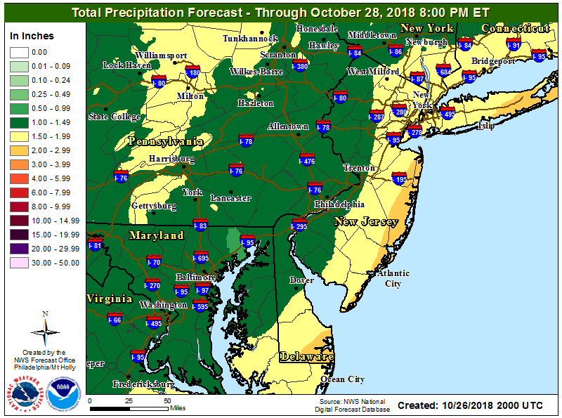
The National Weather Service cautions that new forecast guidance is suggesting heavier rain totals than initially expected. While some larger scale models, such as the American GFS, continue to show mostly 1 to 2 inches across the area, which on their own likely wouldn’t create any widespread issues, high resolution mesoscale models are depicting a band of heavier rain developing in the pre-dawn hours near or just west of the shore. Further exacerbating flooding issues, the strong winds will have the potential to knock down leaves and other tree debris leading to clogged storm drains. Due to this new flood threat, the National Weather Service has issued Flood Watches from Middlesex County down to Cape May county in New Jersey. Sussex County in Delaware may also have some rain amounts above 2 inches, but flash flood guidance suggests heavier rains would be needed to generate flood conditions there. Flash Flood Watches are also up for the New York City metro area, Long Island, southern Connecticut, all of Rhode Island, and southeastern Massachusetts.
Beyond the wind and rain, though, coastal flooding will be a significant issue, with the biggest impact area likely to be near Staten Island and the Raritan Bay in New Jersey. The combination of strengthening easterly winds tonight into Saturday morning and lingering high astronomical tides, as we are only a couple of days away from the recent full moon, is expected to lead to coastal flooding for all coastal areas along the Atlantic Ocean, Delaware Bay, and tidal Delaware River. Winds are expected to be especially strong across the northern New Jersey coast, which may trap water into Raritan Bay. It looks like the surge is expected to max out right around high tide for areas near Sandy Hook, and especially Perth Amboy. It is possible that Perth Amboy may reach major coastal flood levels. The rest of the New Jersey and Delaware coasts under the Coastal Flood Warning are expected to reach the moderate coastal flood level. Those in the advisory area are expected to reach minor coastal flood levels, but may get close to moderate in a few locations. For now, it appears that the only tide cycle in need of a warning or advisory will be the first high tide cycle tomorrow morning; the Saturday evening/night high tide is the lower of the two astronomical high tides and winds shift to an offshore direction by Saturday evening. For now, a Coastal Flood Warning is now in effect for all of the New Jersey and Delaware Atlantic coast, as well as Kent County, Delaware and Middlesex, New Jersey. A Coastal Flood Warning is also up for the western Long Island Sound, including Long Island and southern Connecticut; all of New York City is included in the warning. A Coastal Flood Advisory is now in effect for the remaining counties along the Delaware Bay and tidal Delaware River.
Much of the precipitation in and south of New York City should fall by lunchtime Saturday; much of the precipitation north of New York City to Boston should fall Saturday afternoon. By Sunday, some clouds and widely scattered light rain showers will linger. On Monday, a weaker secondary system will move through, bringing another round of rain to the area hit by the nor’easter.
