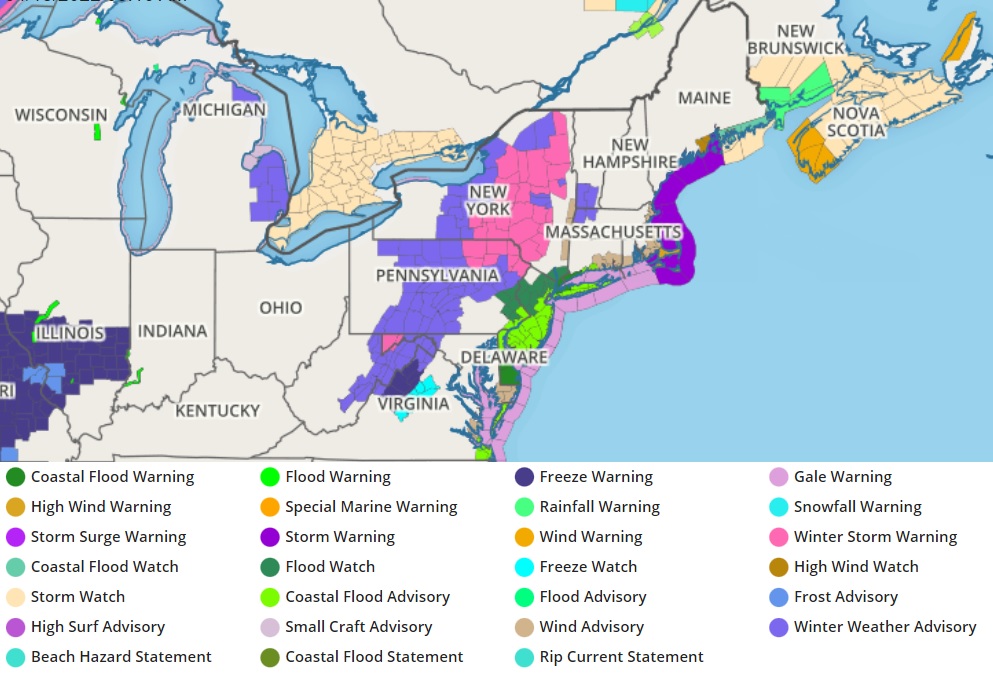
A very late-season nor’easter will bring heavy snow, heavy rain, strong potentially damaging winds, and coastal flooding to portions of the northeast today into tomorrow. Due to the hazards presented by the storm, the National Weather Service has issued Winter Storm Warnings for portions of Maryland, West Virginia, Pennsylvania, and New York while Winter Weather Advisories are up in those states as well as Virginia, Massachusetts, and Vermont. Wind Advisories and High Wind Warnings are up for portions of the coast from Virginia north to Massachusetts while Coastal Flood Advisories are up along portions of Delaware, Pennsylvania, New Jersey, Connecticut, and New York. While heavy snow will fall inland, heavy rain will fall closer to the coast, prompting the issuance of Flood Watches across most of Delaware, New Jersey, southeastern New York, portions of eastern Pennsylvania, and southern Connecticut.
The Nor’Easter will approach the northeast as an area of high pressure heads out to sea today. The intensifying coastal storm will lift up the Mid Atlantic Coast later today into tonight and head to the New England coast by Tuesday morning. As the intense, compact storm moves through, heavy precipitation will move in from south to north.

In higher elevations well away from the coast, snow will fall. Due to the temperature profiles of this storm, the snow will have an exceptionally heavy and wet consistency that will cake onto many surfaces. Due to the weight of this heavy snow, some wires or tree limbs may snap, creating power problems. The snow will pile-up in the Winter Storm Warning areas, where as much as a foot of snow is forecast to fall.
At the coast, conditions will be too mild for snow, resulting in wind-whipped heavy rains. Rainfall of 1.5-2″ is likely, with rainfall rates of 1/4 – 1/2 inch per hour is possible for several hours during the time of heaviest rain. This will lead to ponding on roadways, the threat of urban flash flooding, and broader flooding as area creeks, streams, and rivers react to the sudden heavy rainfall.
In addition to flood threats from the rain, the storm will also help to drive water from the ocean onto the coast and up into bays, resulting in storm surge flooding. The greatest threat of coastal flooding will be in Delaware, New Jersey, Long Island, Connecticut, and southeastern Pennsylvania along the southern Delaware River. There will be a prolonged period of increasing onshore flow ahead of the storm which will result in tide levels at least 1-1.5 feet above astronomical tides. With the full moon on April 16, astronomical high tides are already less than 1 ft below minor flood stage. As such, this amount of surge will likely be enough for widespread minor coastal flooding along the Atlantic coast of New Jersey and Delaware, as well as along Delaware Bay and up the tidal Delaware River. The main tide affected will be the high tide Monday evening/overnight. The National Weather Service also cautions that some computer forecast guidance depicts the potential for a moderate level coastal flooding, primarily for the Kent and Sussex Delaware coasts of Delaware Bay and the ocean front as well as Cape May, Monmouth, and Middlesex Counties in New Jersey. People in coastal communities there should be prepared to take action to protect life and property ahead of that coastal flood threat.
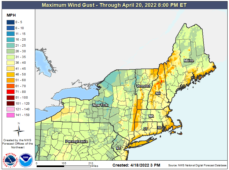
Winds will be strong through the nor’easter, with the highest winds likely at the Jersey Shore, Delaware Beaches, Long Island, the Hudson Valley, Cape Cod, and central and northern New Hampshire. Winds in excess of 40 mph are possible with gusts over 50 mph possible in some coastal communities. The winds could also knock down wires and/or tree limbs, adding to power problems with this storm.
Fortunately, the storm will quickly move north and east, allowing for high pressure to build in from west to east on Tuesday.
While the calendar approaches May, Old Man Winter may not be done yet. Some extended range forecast guidance suggests another threat of elevation-dependent inland snowfall possible again in the first days of May.
