Back-to-back areas of low pressure will bring a double punch of heavy rain to portions of the northeast in the coming days. Right now, it appears punch one arrives Tuesday/Wednesday with the second arriving late Friday/Saturday.
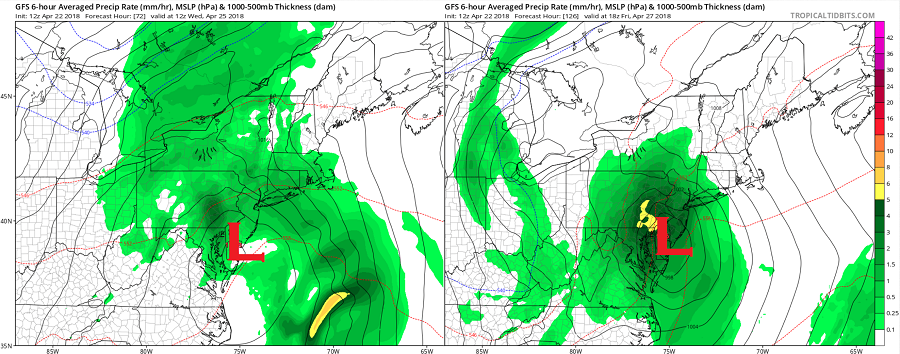
An area of low pressure currently over the deep south today will continue to very slowly progress northeast, reaching the Mid Atlantic by mid week. This low will bring rain to places like Washington, DC, Philadelphia, PA, and New York City, NY on Tuesday. A dry slot will grow within this storm system, helping bring an end to the rain on Wednesday morning. Due to the slow progression of the low and low level onshore flow, there is some concern of heavy rain, primarily Tuesday night. Precipitable water values are expected to be well above normal, possibly in the 90th percentile for this time of year. It appears the highest threat of heavy rain will be along the Coastal Plain of the Mid Atlantic.
Later on Thursday, a short wave trough in the southeast on Friday will interact with the main upper level trough over the north central US setting the stage for the second punch. It appears the trough and associated surface low will become the dominant low, resulting in a coastal storm forming over or near the Garden State on Friday. This system could bring heavier rainfall rates and more in the way of wind than the first punch. As with the first storm, temperatures should be warm enough for all precipitation to fall from both of these systems as rain. However, as cold air mixes in over the highest terrain of the northeast, some wet snow flakes of little consequence could mix in at times early Saturday.
By Sunday, fair high pressure will return, but temperatures won’t rebound too much. A cool unsettled weather pattern is expected to continue for the balance of the month in the northeast.
