Original Images: tropicaltidbits.com
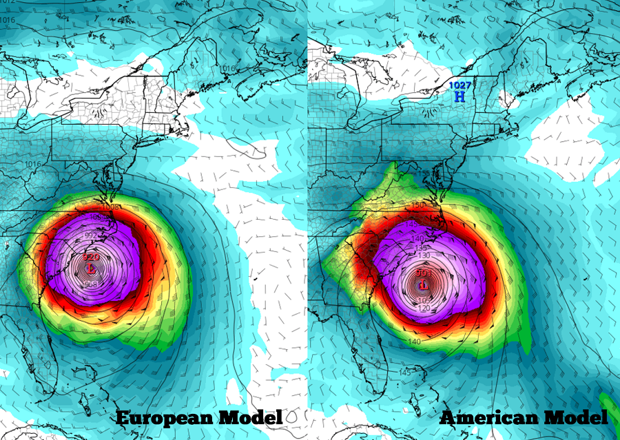
Overnight global forecast guidance from American (GFS) and European (ECMWF) models are in alignment around the idea of a significant landfall of a major hurricane on the US East Coast, although the details involved within both solutions still have their differences. The American model is faster with its thinking, bringing Hurricane Irma north up the US East Coast as early as the night of September 10. Meanwhile, the European is a bit later, showing a US East Coast arrival of Hurricane Irma around September 11. While both models are in good general agreement with each other, it is important to point out that path and intensity forecasts this far out for both models this far out are fair at best and it will take at least another 48 hours to have more confidence in this type of forecast solution proposed by these models.
The National Hurricane Center (NHC) is also stressing that it is still too soon to know with a high degree of certainty where Irma will go and how strong it’ll get before it gets there. “It is much too early to determine what direct impacts Irma will have on the Bahamas and the continental United States. Regardless, everyone in hurricane-prone areas should ensure that they have their hurricane plan in place, as we are now near the peak of the season,” writes the NHC in their Sunday morning forecast discussion on Major Hurricane Irma.
As of 5am AT, Irma was located at 18.0N 47.5W, which puts its roughly 945 miles east of the Leeward Islands. Maximum sustained winds are at 115mph, making it a strong Category 3 hurricane on the Saffir-Simpson wind scale. Minimum central pressure is at 969mb. The storm is moving west south west at 15mph.
Because the storm has a southward component to its general westward motion, global forecast models believe Irma will be far enough south to avoid interaction with a strong cold front that’ll be marching through the United States during the middle to later part of this week. If Irma’s track shifted north enough, that frontal system would be able to help curve the future storm track out to sea. At this time, most model runs, including the overnight (0Z) global deterministic runs, believe Irma will miss this frontal influence. However, as recent as yesterday afternoon, the European ECWMF (12Z) run did show the front helping push the storm more east than west over time. As more data is sampled and crunched in the coming days, the true influence of this very important frontal system will be better known.
While global forecast guidance is rather ominous, we are likely 24-48 hours away from having a firm understanding of Irma’s structure, intensity, and future path and its interactions with the US Mainland. Until that certainty is understood, residents from Florida to Maine and every state in between, should make sure they have a Hurricane Action Plan in place. It is becoming more likely than not that someone along the US East Coast will need to act on that plan later this week.

While those in the US East Coast should make sure they have their Hurricane Action Plan, residents of the Leeward Islands should also brace for potential impacts too. In the latest forecast map from the National Hurricane Center, which only extends to five days in the future, Irma is dangerously close to the Leeward Islands as a Major Hurricane.
Experts believe this Atlantic Hurricane Season, which runs through to the end of November, will be a busy one. Dr. Phil Klotzbach and the experts at Colorado State University updated their seasonal outlook again on July 5, showing a much more active than normal season expected. The National Oceanic and Atmospheric Administration (NOAA) also released their own forecast which shows this hurricane season to be likely more active than others.
