Unlike Hurricane Hector which passed well to the south of Hawaii’s Big Island earlier this summer and Hurricane Lane which brushed by to the west of Hawaii’s Big Island just weeks ago, it appears Olivia, the latest hurricane of the 2018 Central Pacific Hurricane season, will make a direct impact to the Aloha State and pass through the islands somewhere between Kahalui, Maui County and Hilo, Hawaii County late Tuesday. While the center will strike that area, impacts will extend far beyond the center of circulation, prompting the Central Pacific Hurricane Center to issue fresh advisories for Hawaii.
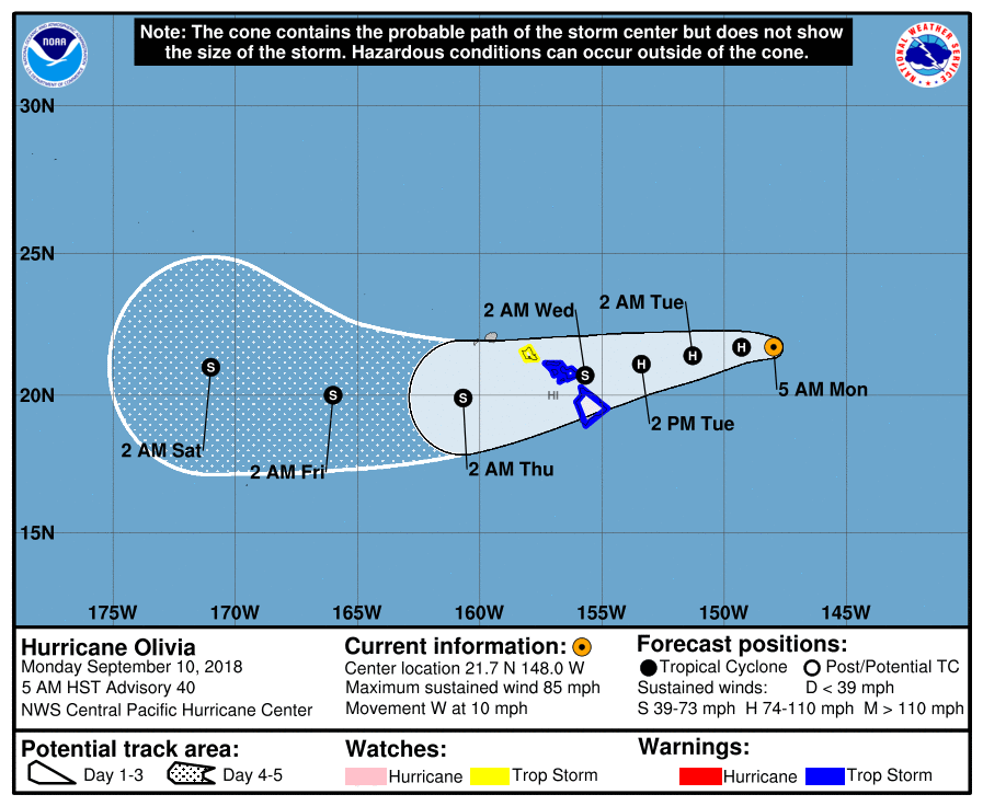
Olivia is taking an extremely unusual path from northeast to southwest near Maui and Hawaii islands; since records were kept in 1949, a storm like this has never hit this area from that direction. Because this is a novel storm track, people typically protected by mountain terrain from other storms may suffer severe impacts from this one. And because the storm center will cross the state, impacts from wind and wind related damage could be far worse with Olivia than they were from Hurricanes Hector and Hurricanes Lane; that is because the center of those hurricanes never reached the state.
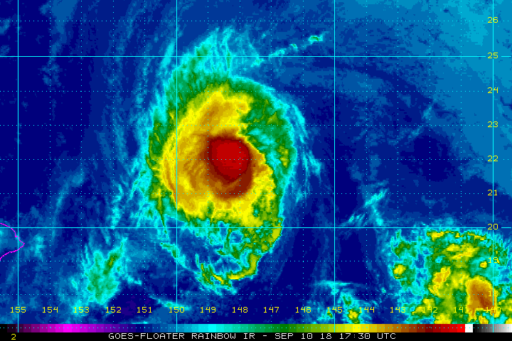
In the last advisory from the Central Pacific Hurricane Center, the center of Hurricane Olivia was located near latitude 21.7 North, longitude 148.0 West. Olivia is moving toward the west near 10 mph. This general motion is expected to continue early today, followed by a turn toward the west-southwest starting later today. This west-southwest motion is expected to continue through Tuesday night. On this forecast track, tropical storm conditions are expected over parts of Hawaii starting late Tuesday. Maximum sustained winds are near 85 mph with higher gusts. Little change in strength is forecast today, with slight weakening starting tonight and continuing through Tuesday. However, Olivia is forecast to be a strong tropical storm when it reaches the Hawaiian Islands. It is within the realm of possibilities, however, that Olivia could maintain hurricane strength as it hits Hawaii. Hurricane-force winds extend outward up to 30 miles from the center and tropical-storm-force winds extend outward up to 115 miles. The estimated minimum central pressure is 980 mb or 28.94 inches.
The storm will bring three primary dangers: destructive winds, flooding rains, and damaging surf. Tropical storm conditions are expected somewhere within the warning area starting late Tuesday. Tropical storm conditions are possible within the watch area starting early Wednesday morning. Olivia is expected to produce total rainfall accumulations of 10 to 15 inches. Isolated maximum amounts of 20 inches are possible, especially over windward sections of Maui County and the Big Island. This rainfall may produce life-threatening flash flooding. Rockfalls and landslides are also possible, which could shut down roads and strand some communities. Large swells generated by Olivia will spread from east to west across the Hawaiian Islands early this week. This will cause surf to build along exposed east facing shorelines as Olivia approaches. This surf may become damaging across parts of the state.
People in Hawaii, whether they’re a resident or a visitor, must rush their Hurricane Action Plans to completion today and make sure they have all of their hurricane supplies in order. If any supplies were consumed during Hurricane Lane, it is important to replenish those stocks.
