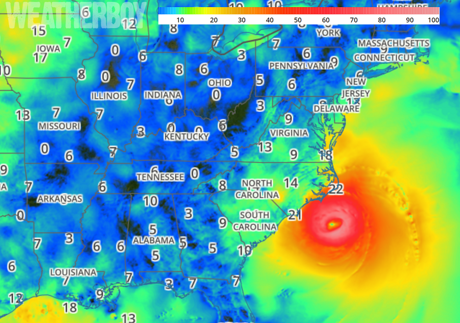
Massive Hurricane Florence’s outerbands have started to make their way over land in the Carolinas as rain, wind, and storm surge builds. While the storm has weakened as it relates to maximum sustained winds, it’s grown larger, expanding its windfield out hundreds of miles. While the Saffir Simpson wind scale rating has dropped, the severity of the storm has increased due to its growing size.
Florence is considered by the National Hurricane Center (NHC) to be a large hurricane. Hurricane-force winds extend outward up to 80 miles from the center and tropical-storm-force winds extend outward up to 195 miles . NOAA Buoy 41025, located near Diamond Shoals, North Carolina, recently reported a
sustained wind of 54 mph. A NOAA reporting station at Cape Lookout, North Carolina, recently reported a sustained wind of 45 mph and a gust to 54 mph. A Weatherflow private observing station in Pamlico Sound, North Carolina, recently reported a sustained wind of 51 mph and a gust to 61 mph.
Despite impacts being felt in North Carolina, the storm center is still well off-shore. As of 1pm., it was located near 33.6N and 75.9W, which is about 115 miles east south east of Wilmington, NC and about 175 miles east of Myrtle Beach, SC. Maximum sustained winds are 105mph with higher gusts. The storm is moving to the northwest at 10mph while the minimum central pressure is 955mb or 28.20 inches.
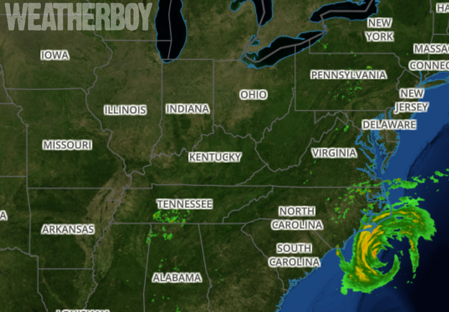
While most of the rain remains off-shore, that will change over time as incredible amounts of moisture flow into the Carolinas. The latest RADAR imagery shows the heavy rain still off-shore, but outer bands are beginning to rotate into eastern Virginia and North Carolina. Rainfall will be epic with life threatening and property destroying flash flooding likely later today; 30-50″ of rain could fall from this hurricane before it ends in the next few days.
Right now, a variety of watches and warnings are in effect ahead of Florence’s arrival. A Storm Surge Warning and Hurricane Warning is in effect for South Santee River, South Carolina to Duck, North Carolina, and the Albemarle and Pamlico Sounds, including the Neuse and Pamlico Rivers. A Storm Surge Watch and Hurricane Watch is in effect for Edisto Beach, South Carolina to South Santee River, South Carolina and north of Duck, North Carolina to the North Carolina/Virginia border. A Tropical Storm Warning is in effect for north of Duck North Carolina to Cape Charles Light, Virginia and for the Chesapeake Bay south of New Point Comfort. A Storm Surge Warning means there is a danger of life-threatening inundation, from rising water moving inland from the coastline. This storm surge issue is a life-threatening situation. Persons located within these areas should take all necessary actions to protect life and property from rising water and the potential for other dangerous conditions. Promptly follow evacuation and other instructions from local officials. A Storm Surge Watch means there is a possibility of life-threatening inundation, from rising water moving inland from the coastline. A Hurricane Warning means that hurricane conditions are expected somewhere within the warning area, in this case within the next 12 to 24 hours. Preparations to protect life and property should be nearing completion. A Hurricane Watch means that hurricane conditions are possible within the watch area. A watch is typically issued 48 hours before the anticipated first occurrence of tropical-storm-force winds, conditions that make outside preparations difficult or dangerous. A Tropical Storm Warning means that tropical storm conditions are expected somewhere within the warning area.
