• Skip to primary navigation
  • Skip to main content
  • Skip to primary sidebar

Weatherboy

Weatherboy Weather News, Maps, RADAR, Satellite, and Forecasts.

  • Local
  • Earth Science News
  • RADAR
  • Current Warnings
  • Satellite
  • Current Maps
  • Forecast Maps
  • Video

Pacific Becoming Active, Atlantic Still Quiet in Hurricane Season

by Weatherboy Team Meteorologist - June 22, 2018

While the Atlantic is quiet, the National Hurricane Center is monitoring two areas that could develop into a tropical cyclone over time in the Eastern Pacific.  Image: NHC
While the Atlantic is quiet, the National Hurricane Center is monitoring two areas that could develop into a tropical cyclone over time in the Eastern Pacific. Image: NHC


As we enter the third week of the 2018 Atlantic and Central Pacific Hurricane seasons, things are quiet with no disturbances and forecasts of none likely for at least the next five days. The same isn’t true for the Eastern Pacific, where the National Hurricane Center believes two systems could form.

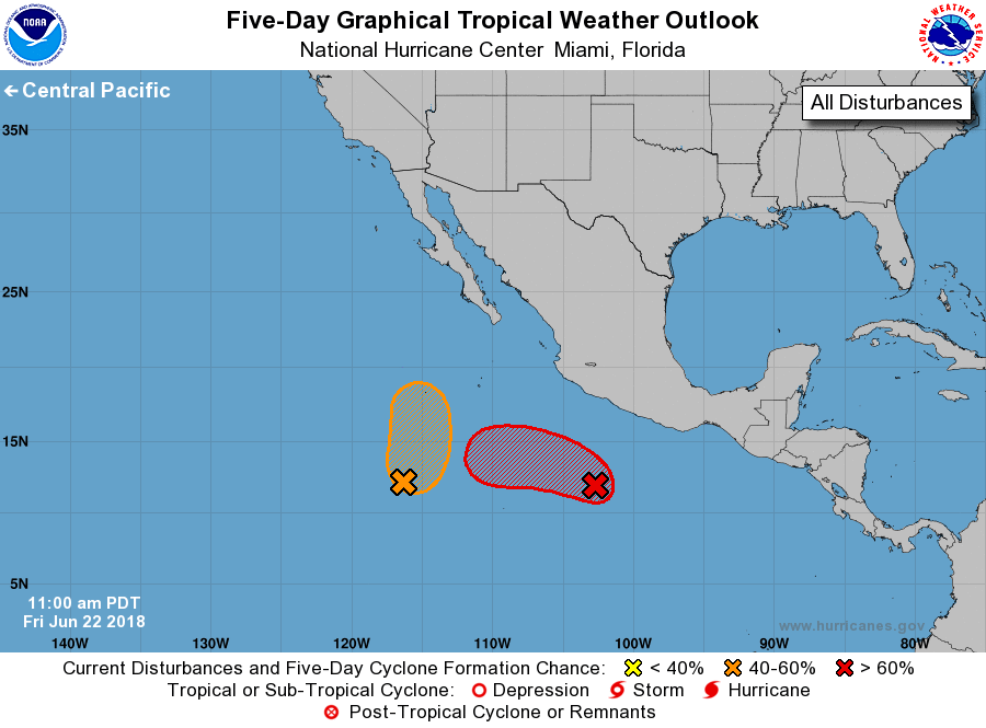
Showers and thunderstorms are increasing near a broad area of low pressure located several hundred miles south-southwest of Acapulco, Mexico. Upper level winds are expected to become more conducive for development over the next day or so, and according to the National Hurricane Center, a tropical depression is likely to form early next week while the disturbance moves westward to west-northwestward at 5 to 10 mph away from the coast of Mexico. The National Hurricane Center believes there’s a 70% chance of formation over the next 5 days.


A second broad and elongated area of low pressure located about 800 miles south-southwest of the southern tip of the Baja California peninsula continues to produce shower and thunderstorm activity, which has increased slightly in organization. According to the National Hurricane Center, environmental conditions are expected to be somewhat conducive for development over the next few days, and a tropical depression could form over the weekend while the disturbance moves toward the north or north-northeast at about 5 mph over the open eastern North Pacific. The system is expected to reach cooler waters early next week, which will limit the potential for development. With some conditions favorable for development but many factors against development, the National Hurricane Center believes there’s only a 50-50 chance that this system will develop over the next five days.

Primary Sidebar

Sponsored Ad

Search

Latest News

  • Military Warns of “High Noise” Event in New Jersey Later in July; Weather Could Be a Factor
  • USGS Keeping Four U.S. Volcanoes at Elevated Risk Alert Levels this Holiday Weekend
  • Tropical Storm Colin Weakens to Depression; Warnings Dropped
  • Tropical Storm Bonnie Enters the Pacific, On its Way to Become a Hurricane; Could Bring Moisture to Hawaii
  • Puerto Rico & the USVI Is Shaking this Holiday Weekend; More than 475 Earthquakes Strike the Region; No Tsunami Threat at this Time
  • Earthquakes Rattle Southern Missouri near New Madrid, Home of Violent 1811 Quake
  • Tropical Storm Colin Forms along South Carolina Coast; Warnings Issued for U.S. East Coast
  • Tropical Trouble Brewing Along U.S. East Coast?
About | Careers | Contact | Contests
Terms | Privacy | Ad Choices
Weatherboy is a (R) Registered Trademark of isarithm LLC, All Rights Reserved.
All content herein is Copyright by Isarithm LLC 1997-2022