The National Hurricane Center in Miami, Florida is busy tracking three areas of concern across the Atlantic Hurricane Basin today; one is Subtropical Storm Patty which should reach Portugal by Tuesday or Wednesday; the other is a developing system in the northwest Caribbean that could eventually become a named system and impact the U.S. Gulf Coast. The next tropical storm that forms in the basin will be named Rafael.
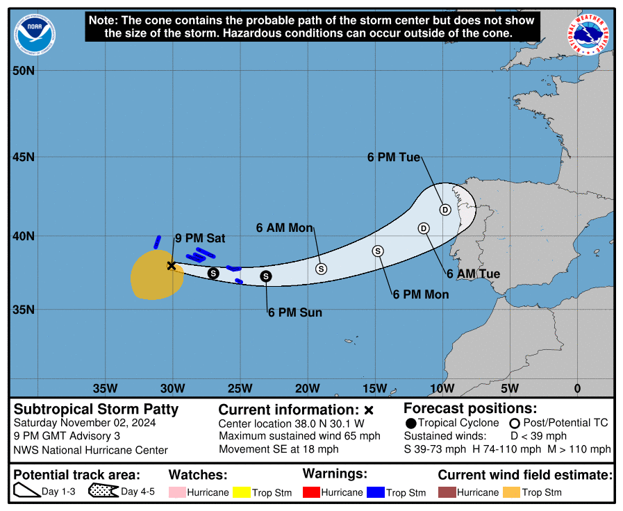
Patty is near the Azores now with maximum sustained winds of 65 mph. The storm is moving to the southeast at 18 mph while its minimum central pressure is down to 982 mb. A Tropical Storm Warning is in effect for all of the Azores, where tropical storm conditions are expected this weekend. An eastward motion is expected during the next couple of days. On the forecast track, the center of Patty is expected to move near or just south of the Azores through Sunday. Once it gets through the Azores, it should move north and east, eventually reaching Europe by Tuesday or Wednesday, bringing wind-whipped rains to Portugal and Spain.

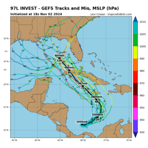
Of greater concern to the United States is a disturbance in the southwestern Caribbean Sea. A broad area of low pressure over the southwestern Caribbean Sea continues to produce disorganized showers and thunderstorms. According to the National Hurricane Center, gradual development of this system is expected, and a tropical depression is likely to form within the next couple of days while it moves generally northward to northwestward over the central and western Caribbean Sea. Regardless of development, locally heavy rains are possible over portions of the adjacent land areas of the western Caribbean, including Jamaica, Hispaniola, and Cuba.
An Air Force Hurricane Hunter aircraft is scheduled to investigate this developing system on Sunday.
The National Hurricane Center believes there are high odds that a tropical cyclone will form here; they say there’s a 70% chance of formation over the next 48 hours and 80% for over the next 7 days.
Another area being monitored by the National Hurricane Center is near the Greater Antilles. A trough of low pressure just north of Puerto Rico and Hispaniola continues to produce disorganized showers and thunderstorms, and gusty winds. Slow development of this system is possible during the day or two while it moves westward near the Greater Antilles; however, by early next week, this system is expected to be absorbed into the low pressure area over the Caribbean Sea. Regardless of development, locally heavy rains are possible during the next couple of days across the northern Leeward Islands, Puerto Rico, Hispaniola, eastern Cuba and the southeastern Bahamas.
Global computer forecast models used by meteorologists to aid with their tropical cyclone forecasts have not been consistent with their output in recent days. While most are in agreement that a tropical cyclone will move about in the Gulf of Mexico by the middle of next week, they haven’t provided clear guidance on how strong the system will become or where it’ll go. Forecasters say some clarity to the forecast should arrive by Monday.
The Atlantic Hurricane Season runs through the end of this month.
