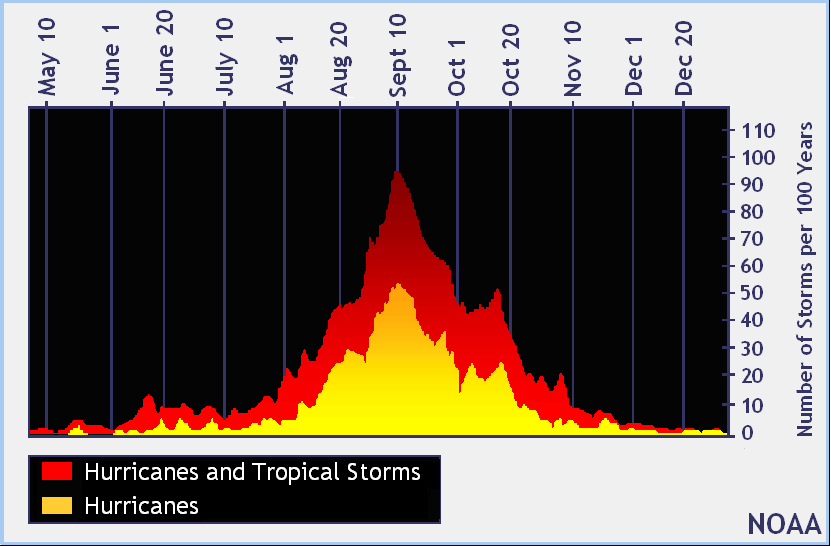
The traditional peak of Atlantic Hurricane Season is considered to be September 10; this year, that peak could be hurricane-less in a relatively tame season to date. The National Hurricane Center’s (NHC) latest Tropical Outlook also shows there are no high odds of a new tropical cyclone forming over the next five days, giving people along the U.S. East and Gulf coast another reprieve from what is forecast to be an above-normal season.
The official hurricane season for the Atlantic basin is from June 1 to November 30, but tropical cyclone activity sometimes occurs before and after these dates, respectively. The peak of the Atlantic hurricane season is September 10, with most activity occurring between mid-August and mid-October.
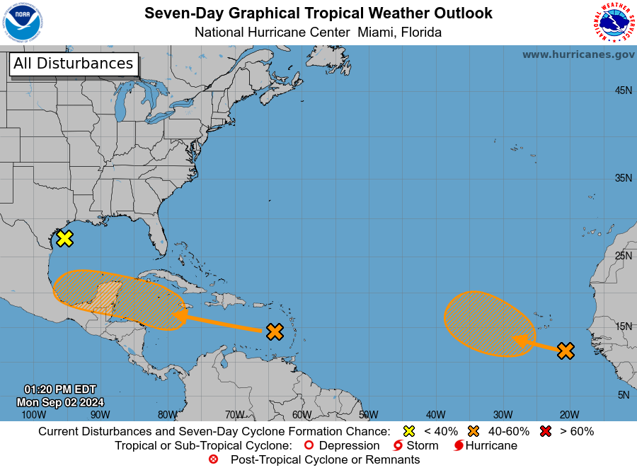
In the latest Tropical Outlook released by the NHC today, they are tracking three potential systems in the Atlantic; none have a high chance of developing into a tropical cyclone anytime soon.
The first system being monitored is a broad and weak area of low pressure just offshore of the middle Texas coast. Today, it continues to produce some disorganized shower activity along portions of the coast of Texas and over the adjacent waters of the northwestern Gulf of Mexico. This system is expected to move inland early Tuesday, and the National Hurricane Center says development is not expected. Regardless, heavy rains could cause some flash flooding across portions of the Texas coast during the next day or two.
The second system is near the Lesser Antilles and the Caribbean Sea. There, a tropical wave is producing disorganized thunderstorms and gusty winds across portions of the Lesser Antilles, Puerto Rico, Hispaniola and over the adjacent waters. Environmental conditions are forecast to become more conducive for development when the system reaches the western Caribbean Sea and southwestern Gulf of Mexico late this week and over the weekend, and a tropical depression could form during that time. But for now, the National Hurricane Center says there’s only a 40% chance that this disturbance will become a tropical cyclone over the next 7 days.
The third system is in the far eastern Atlantic, where a tropical wave over the far eastern Atlantic is producing disorganized showers and thunderstorms. Environmental conditions are forecast to become a little more conducive for development, and a tropical depression could form in a few days while the disturbance moves slowly west-northwestward or northwestward over the eastern tropical Atlantic Ocean. This system could produce areas of heavy rain and gusty winds across portions of the Cabo Verde Islands in a day or two. The National Hurricane Center says there’s only a 40% chance this system will become a tropical cyclone over the next 7 days too.
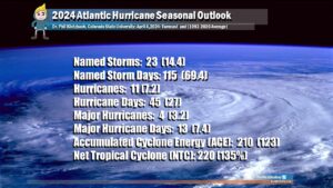
Earlier this year, leading tropical meteorology forecasters unveiled seasonal outlooks that called for a season with above-normal activity. The first was a study from Colorado State University, which was unveiled on April 4. That research endeavor, partially funded by Weatherboy, called for 23 named storms, 11 hurricanes, and 4 major hurricanes.

NOAA was in general agreement with the CSU outlook. In May, they released their own outlook for the season. The NOAA forecast is calling for a range of 17 to 25 total named storms (winds of 39 mph or higher). Of those, 8 to 13 are forecast to become hurricanes (winds of 74 mph or higher), including 4 to 7 major hurricanes (category 3, 4 or 5; with winds of 111 mph or higher).
In a typical season, there are 14 named storms, 7 hurricanes, and 3 major hurricanes.
However, that doesn’t appear to be the case –yet.
The 2024 Atlantic Hurricane Season, which started on June 1, had a late start. Tropical Storm Alberto formed on June 19 making it the latest first storm of the Atlantic Hurricane Season in 2024. Alberto brought flooding rains to portions of Central America but never grew stronger than a tropical storm.
Later in June Hurricane Beryl formed. On July 8, Beryl made landfall near Matagorda, Texas with sustained winds of 80 mph; from there, the system quickly weakened and moved inland, but even as a weak storm, it dumped extremely heavy rain over portions of Texas.
Tropical Storm Chris formed quickly at the end of June too and weakened after crossing the rough terrain of Mexico on July 1. It brought heavy flooding to portions of Texas which forced thousands from their homes; at least 5 were killed by flood waters in Veracruz created by the storm.
On August 2, a tropical depression formed and was upgraded to Tropical Storm Debby the next day. On the fourth, it was upgraded to a hurricane before making landfall on Florida. A few days later, Debby made another landfall in South Carolina. It too was a significant rain maker, dumping extremely heavy rain over South Carolina.
Ten days later on August 12, Hurricane Ernesto formed. It brought heavy rain to the Lesser Antilles and eventually struck Bermuda on August 17 as a category 1 hurricane. Since then, there have been no additional named storms in the Atlantic.
“I urge everyone to remain vigilant as we enter the peak months of hurricane season,” said U.S. Secretary of Commerce Gina Raimondo. “The experts at NOAA will continue to provide the science, data and services needed to help communities become hurricane resilient and climate-ready for the remainder of hurricane season and beyond.”
“As is the case with all hurricane seasons, coastal residents are reminded that it only takes one hurricane making landfall to make it an active season for them,” the CSU outlook warns. “They should prepare the same for every season, regardless of how much activity is predicted.”
“Although it has been a relatively slow start to hurricane season, with no major storms developing in the Atlantic, this is not unusual and we therefore cannot afford to let our guard down,” said FEMA Administrator Deanne Criswell at a media event . “This is especially important as we enter peak hurricane season—the next Ida or Sandy could still be lying in wait.”
