There is plenty of tropical trouble in the forecast; leading hurricane researchers unveiled their outlook for the upcoming Atlantic Hurricane Season, and the forecast doesn’t look good: an epic number of tropical storms and hurricanes are expected, some of which could make landfall on the U.S. East and Gulf Coasts.
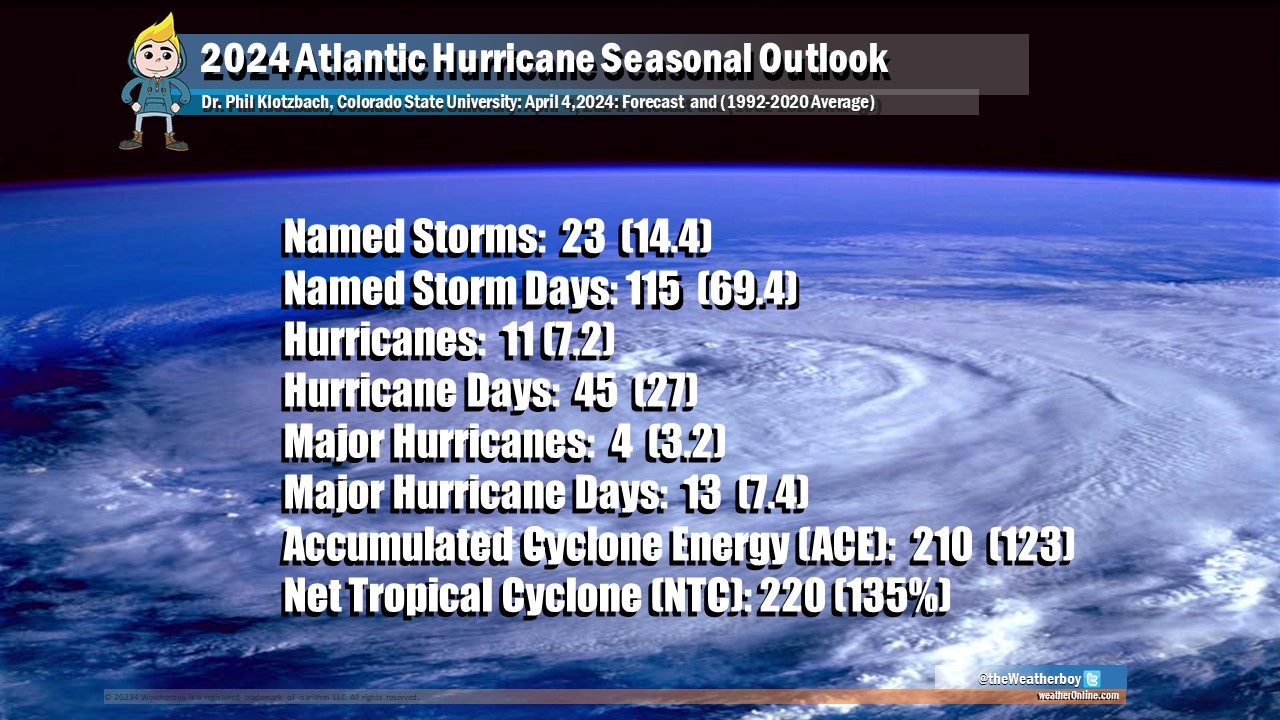
The team of researchers from Colorado State University (CSU) unveiled their 2024 seasonal outlook at the National Tropical Weather Conference in South Padre Island, Texas. Citing record warm tropical and eastern subtropical Atlantic sea surface temperatures as a primary factor, they are calling for 23 named storms this season rather than the usual 14, with 45 days featuring a hurricane compared to the normal 27. The Atlantic Hurricane Season begins on June 1 and runs through to the end of November.
According to the scientists that worked on the report at CSU, when waters in the eastern and central tropical and subtropical Atlantic are much warmer than normal in the spring, this tends to force a weaker weaker subtropical high and associated weaker winds blowing across the tropical Atlantic. Because of this, there will probably be a continuation of well above-average water temperatures in the tropical Atlantic for the peak of the 2024 Atlantic hurricane season which arrives in early/mid September. A very warm Atlantic favors an above-average season, since a hurricane’s fuel source is warm ocean water. In addition, a warm Atlantic leads to lower atmospheric pressure and a more unstable atmosphere. Both of these conditions favor hurricanes.
In addition to an unusually warm Atlantic, scientists are also looking at conditions over the Pacific which drives conditions not just there, but across the U.S. and the Atlantic hurricane basin too. While the tropical Pacific is currently characterized by weak El Niño conditions, these are likely to transition to La Niña conditions by the peak of the Atlantic hurricane season from August–October. La Niña tends to decrease upper-level westerly winds across the Caribbean into the tropical Atlantic. These decreased upper-level winds result in reduced vertical wind shear, favoring Atlantic hurricane formation and intensification.
Forecasters say the upcoming season appears to be analogous to the 1878, 1926, 1998, 2010, and 2020 hurricane seasons.
“Our analog seasons were all very active Atlantic hurricane seasons,” said Phil Klotzbach, research scientist in the Department of Atmospheric Science at CSU and lead author of the report. “This highlights the somewhat lower levels of uncertainty that exist with this outlook relative to our typical early April outlook.”
This is the 41st year that the CSU hurricane research team has issued an Atlantic basin seasonal hurricane forecast. The Tropical Meteorology Project team is comprised of several other researchers from the Department of Atmospheric Science including Professor Michael Bell, Ph.D. candidate Alex DesRosiers, and Research Scientist Levi Silvers. The department is part of the Walter Scott, Jr. College of Engineering at CSU and is one of the top ranked programs in the world. Professor Emeritus Bill Gray originated the seasonal forecasts.
The work is supported by sponsorships provided by Weatherboy Weather, the Insurance Information Institute, Ironshore, a Liberty Mutual Company, and IAA Holdings.
While the outlook calls for the number of storms, it doesn’t forecast exactly where they will go. CSU Professor Michael Bell, who helped author the research, warned, “It takes only one storm near you to make this an active season for you.”
