• Skip to primary navigation
  • Skip to main content
  • Skip to primary sidebar

Weatherboy

Weatherboy Weather News, Maps, RADAR, Satellite, and Forecasts.

  • Local
  • Earth Science News
  • RADAR
  • Current Warnings
  • Satellite
  • Current Maps
  • Forecast Maps
  • Video

Puerto Rico is Shaking: 180+ Earthquakes Rock the Island Over Last 7 Days; No Tsunami Threat

by Weatherboy Team Meteorologist - February 8, 2022

Each dot reflects the epicenter of each earthquake reported in and around Puerto Rico in recent days; the orange dots reflect the more recent quakes. Image: USGS


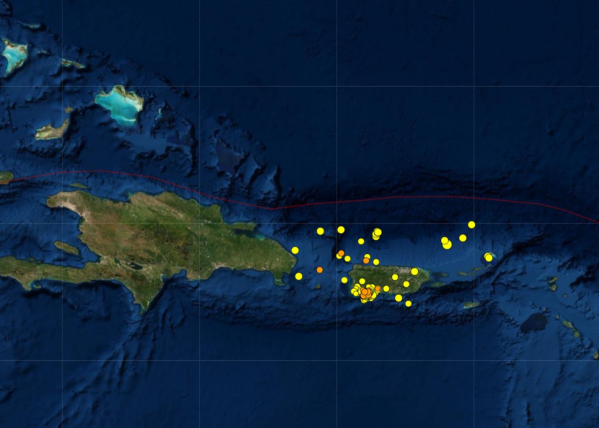
More than 180 earthquakes have rocked Puerto Rico in the last 7 days, with 13 striking in just the last 24 hours. Fortunately, while the volume of earthquakes is high, the intensity has been low; as such,  there is no tsunami threat to the island, the Caribbean, or the U.S. East Coast at this time. According to USGS, most of the earthquakes struck along the southwestern portion of Puerto Rico, although earthquakes have been measured all around the island and in off-shore waters to the east, north, northeast, and southeast.

The earthquakes range in intensity, with the strongest being a 4.1 and 3.8.  Four earthquakes struck with at a magnitude 3.8 rating. from a magnitude 2.5 event to a 2.9 event. The 2.9 magnitude event struck near Guanica, Puerto Rico. 48 of the 183 earthquakes were rated below 2.0, which would make those barely noticeable to people on the island.

It is likely that today’s earthquakes are aftershocks from a seismic event that unfolded in 2020. In January 2020, a 6.4 created extensive damage in Puerto Rico, including widespread power failures across much of the island.  An earthquake swarm started here in December 2019 and the seismic unrest has continued since.


These earthquakes are occurring near  the northern edge of the Caribbean Plate, a mostly oceanic tectonic plate underlying Central America and the Caribbean Sea off of the north coast of South America.  The Caribbean Plate borders the North American Plate, the South American Plate, the Nazca Plate, and the Cocos Plate. The borders of these plates are home to ongoing seismic activity, including frequent earthquakes, occasional tsunamis, and sometimes even volcanic eruptions.


Primary Sidebar

Sponsored Ad

Search

Latest News

  • Military Warns of “High Noise” Event in New Jersey Later in July; Weather Could Be a Factor
  • USGS Keeping Four U.S. Volcanoes at Elevated Risk Alert Levels this Holiday Weekend
  • Tropical Storm Colin Weakens to Depression; Warnings Dropped
  • Tropical Storm Bonnie Enters the Pacific, On its Way to Become a Hurricane; Could Bring Moisture to Hawaii
  • Puerto Rico & the USVI Is Shaking this Holiday Weekend; More than 475 Earthquakes Strike the Region; No Tsunami Threat at this Time
  • Earthquakes Rattle Southern Missouri near New Madrid, Home of Violent 1811 Quake
  • Tropical Storm Colin Forms along South Carolina Coast; Warnings Issued for U.S. East Coast
  • Tropical Trouble Brewing Along U.S. East Coast?
About | Careers | Contact | Contests
Terms | Privacy | Ad Choices
Weatherboy is a (R) Registered Trademark of isarithm LLC, All Rights Reserved.
All content herein is Copyright by Isarithm LLC 1997-2022