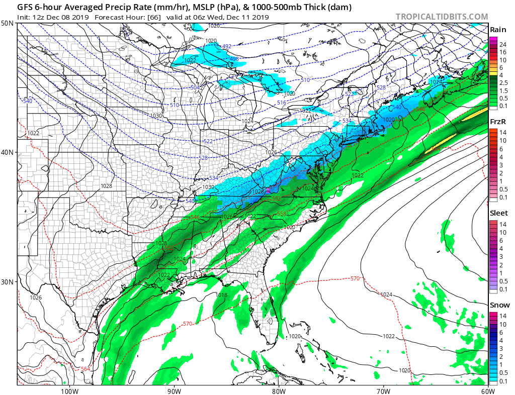
An area of low pressure will bring soaking rains on Monday and Tuesday to much of the U.S. East Coast, with showers and storms in Florida to heavy rain in Maine; however, arriving colder air will turn some of that precipitation to accumulating snow, with the most expected to fall in the Mid Atlantic on Wednesday.
On Tuesday, the primary weather system will be bringing soaking rains to much of New England and the Mid Atlantic region as a cold front approaches from the west. Ahead of the cold front, the rain will become more showery in nature as temperatures rise a bit; temperatures may even exceed 70 degrees around the DelMarVa peninsula and points south. As the front gets closer and a vorticity impulse tracks up along it, another steadier period of rain or showers is likely by later in the day from southern New England south. Generally 1-2″ of rain will fall ahead of and through the cold front passage.
As the cold front sags into the southern Mid Atlantic, it’ll slow down, allowing a path for new atmospheric impulses to ride up along late Tuesday into Wednesday. While this is happening, cold high pressure to the north will begin flowing much colder air into the eastern U.S. In this type of set-up, the high pressure usually boots the front out to sea, bringing cold and dry air with it. But with this system, it looks like the high will be strong enough to send cold air into the eastern U.S. but not be quite strong enough to give the front and its associated impulses the boot off the coast. As a result, precipitation falling from these impulses will fall as snow on the northern side of the system, setting the stage for a band of accumulating snow from Arkansas and Tennessee northeast into the Mid Atlantic into southeastern New England.
There were two similar set-ups to this system already this year; the most recent brought snowflakes to places like the Jersey Shore in the days before Thanksgiving without any accumulation. With a little more cold air and precipitation to work with, accumulations are more likely than those previous storm systems. However, snow that will fall will be light and will struggle to accumulate due to the prior mild air and rain.
The best chance of accumulating snow will be from southern West Virginia into western Virginia, central Maryland, eastern Pennsylvania, interior New Jersey, the New York City metro area, and much of southeastern New England. Generally 1-3″ is expected to fall, with isolated 4-5″ amounts possible, especially over the higher terrain of West Virginia and Virginia.
Snow should wrap up from west to east Wednesday morning and afternoon, with that high pressure finally asserting control of the weather in the East. Thursday looks especially cold, with highs likely struggling to crack the freezing mark in most areas just two days after being in the 60s. Conditions should remain dry for the end of the work/school week before the next system arrives.