Another catastrophe appears to be in the making: Tropical Storm Iota is forecast by the National Hurricane Center to go through a period of rapid intensification prior to landfall in Central America. In an area hit hard by Major Hurricane Eta just 10 days ago, another round of epic, flooding rains, serious wind damage, and a life-threatening storm surge are expected to overwhelm the storm-battered nations of Nicaragua and Honduras once again.
There are no Hurricane Watches up yet, but the National Hurricane Center warns that one is likely to be issued later today.
As of the latest advisory from the National Hurricane Center, Tropical Storm Iota was located near 13.5N and 74.8W, which is roughly 340 miles south-southeast of Kingston, Jamaica and about 570 miles due east of Gracias a Dios on the Nicaragua/Honduras border. Maximum sustained winds are 40 mph while the minimum central pressure is 1005 mb or 29.68 inches.
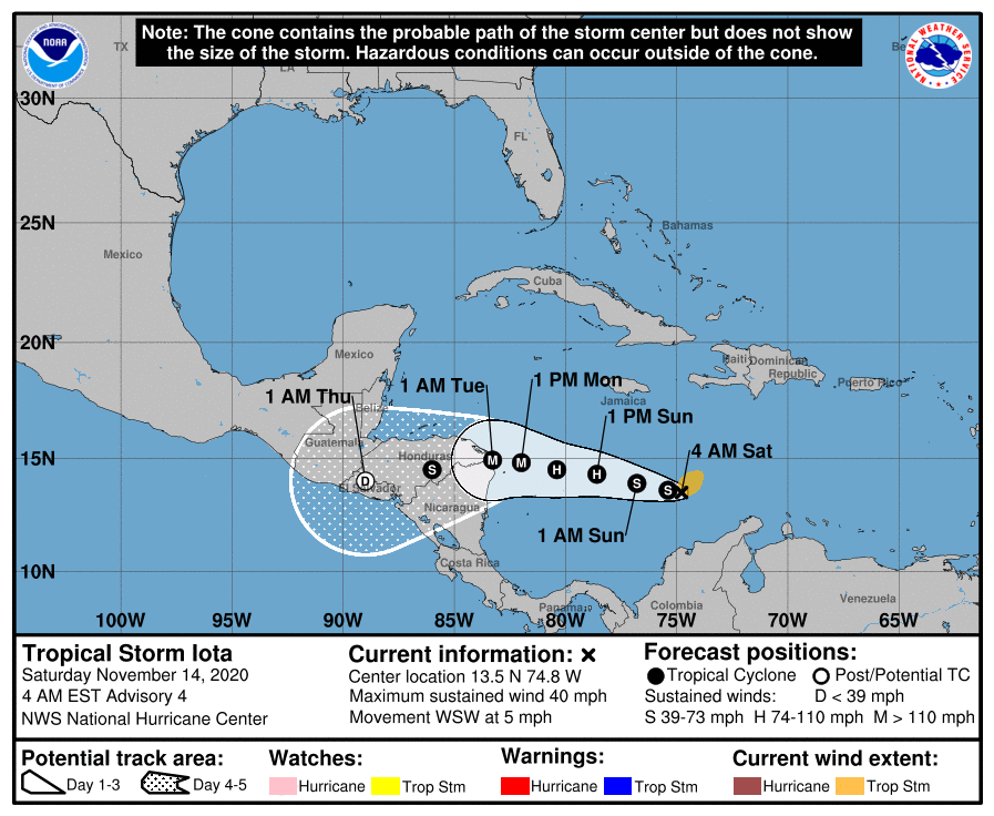
The National Hurricane Center expects Iota to begin a process of rapid intensification, bringing the 40 mph tropical storm to a 120 mph hurricane by the weekend. It is forecast to remain a major hurricane with over 110 mph maximum sustained winds as it approaches Central America on Monday.
Right now, Iota is moving toward the west-southwest near 5 mph. A westward motion with some increase in forward speed is expected to begin later today and continue through Monday. On the forecast track, Iota will move across the central Caribbean Sea during the next day or so, and approach the coasts of Nicaragua and northeastern Honduras on Monday.
On top of the 1-3 feet of rain the area saw from Eta just a week and a half ago, Iota will dump widespread 8-16″ amounts of rain with isolated maximum totals of 20-30″ possible too, especially from northeast Nicaragua into northern Honduras. This rainfall would lead to significant, life-threatening flash flooding and river flooding, along with mudslides in areas of higher terrain.
