After a storm that provided residents with a sneak peak of winter nearly a month before it officially begins, it appears Old Man Winter will be making his presence known. While this is an especially busy week for Thanksgiving travelers, the weather should cooperate for the most part with no widespread heavy rain or snow expected. But that could change as the month ends, with another major east coast winter storm possible.

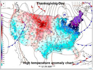
Relatively quiet weather is expected for the eastern two-thirds of the country for Thanksgiving Day. However, an outbreak of Arctic air is forecast to drop temperatures well below freezing for the Northeast, where temperatures will be more than 30 degrees colder than normal over interior New England. Further south, into the central Mid Atlantic, temperatures will struggle to get above freezing. On the other hand, warmer than normal temperatures will spread into the northern Plains.
While much of the country will be free of storms for Thanksgiving and key travel days, unsettled weather is expected to move across the western U.S. associated with a Pacific frontal system. That system will bring showery conditions across the country as it moves through later in the week. When it reaches the coast by next weekend, it’ll likely re-intensify. It’ll also bring milder air up the coast as it does so. As such, mainly rainy conditions are expected in the northeast next Sunday and Monday.
Once that system departs, eyes will be on the weather pattern across the continental U.S. Long range computer forecast guidance has been consistently showing signals that a significant winter storm will form once again along the U.S. east coast. Such a storm could produce more precipitation and wind than the early season snowstorm that impacted the northeast last Thursday. It is too soon to know with certainty how this storm will unfold, but it is becoming more likely than not that a significant winter storm will develop in the eastern US during the last days of November or the first days of December