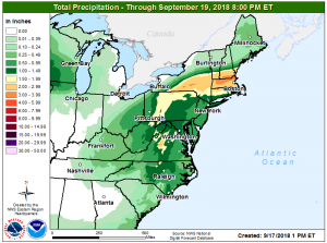
While flood waters continue to rise in portions of the Carolinas due to the unprecedented heavy rainfall from Hurricane Florence, flooding is becoming a possibility for portions of the northeast too as the remnants from the former hurricane head there.
The remnants of Florence will interact with a frontal system that is pushing across the region tonight into Tuesday. Showers will work in from the southwest as the remnants of Florence interact with the westerlies and the system transitions to extratropical. Strengthening warm advection coupled with a southerly low-level jet will allow for the showers to become widespread as the night progresses. The axis of heaviest rainfall will reside across the Lower Hudson Valley and across interior Connecticut and Rhode Island and into northern Massachusetts. Lesser amounts are expected toward the coast. Rainfall amounts of around 0.25-0.5″ are expected at the south New England coast, with 1-3″ likely further inland.
With the warm frontal passage overnight in conjunction with the low-level jet, the air mass will destabilize aloft with the chance for embedded thunderstorms. With robust tropical moisture around, some of these isolated storms could dump extremely heavy rain over a very small, localized area. Beyond threats of flooding from the overall heavy rain pattern, people should be on alert for flash flood issues that could pop-up anywhere, including at the coast and/or in urban areas, from these thunderstorms.