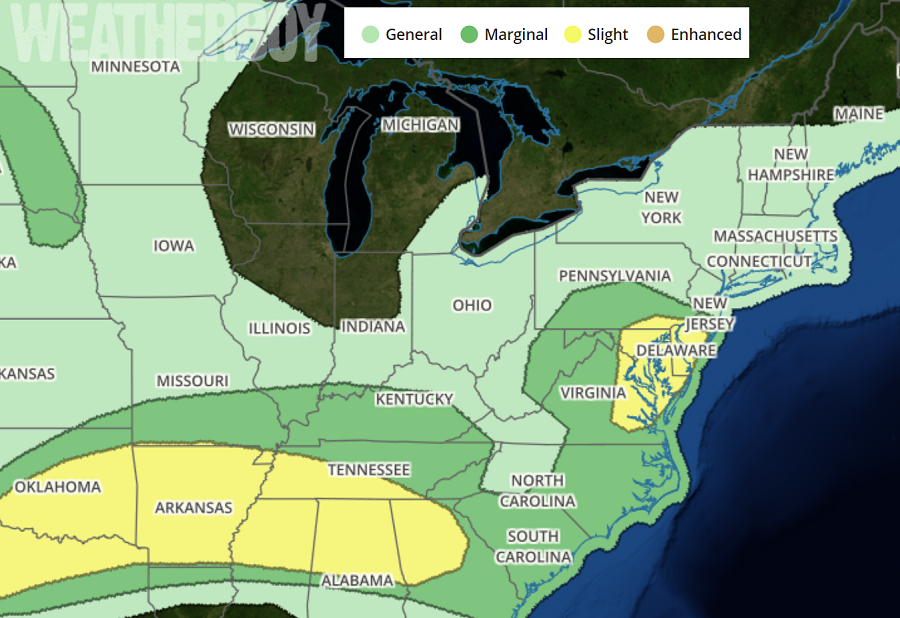
The National Weather Service’s Storm Prediction Center warns that today’s weather may turn severe, especially in portions of the South and the Mid Atlantic.
In the Mid Atlantic, the greatest threat of severe weather is over southern New Jersey, all of Delaware, eastern Maryland, southeastern Pennsylvania, and northeastern Virginia. In this region, the greatest severe weather threats will be from damaging wind gusts and large hail. While an isolated tornado is possible, it is unlikely in this area today. A warm front will lift north through Virginia and Pennsylvania during the day today ahead of a cold front accompanying a shortwave trough. Diabatic warming of the moist warm sector will result in moderate instability. A belt of stronger winds aloft will accompany the upper low as it shifts northeast and transitions to an open wave. Storms are expected to develop over the higher terrain with a lee trough across central Virginia also becoming a focus for development. Storms may organize into broken bands as they develop east with also some potential for mid-level updraft rotation Damaging wind will be the main threat here, but some large hail will also be possible.
In an area stretching from the Lower Mississippi River Valley into the interior southeast, severe storms are also possible. A mesoscale convective system will continue to march through this area, elevating the risk of weather-related damage. As with the Mid Atlantic, the greatest risks from these storms will be damaging hail and/or wind gusts. Here a stray tornado is also possible, but not widespread tornado event is expected from today’s storms here.
These areas can also see very heavy downpours of rain, especially as severe storms blossom. Some rain could fall at rates greater than 1″/hour, leading to flash flooding. People are reminded: turn around, don’t drown; never drive through flood waters.
