Heavy flooding rains and another round of severe weather are expected as yet another severe storm system marches across the United States. A synoptic-scale trough is responsible for the latest round of wet and wild weather to impact the country.
Today, severe thunderstorms may produce damaging gusts, isolated large hail, and a few tornadoes –some of which the National Weather Service’s Storm Prediction Center says could be especially strong. Today’s severe weather will be anchored around the Mississippi Valley through the central Gulf Coast region; Louisiana, Mississippi, and Alabama are in the prime target for the most severe conditions.

Numerous thunderstorms are possible from the Mid-Atlantic States southward to Florida tomorrow; some of these storms will be capable of producing damaging wind gusts. According to the Storm Prediction Center, a few tornadoes are also possible.
On Friday, a deep upper trough extending along the Mississippi Valley will continue marching eastward on Friday while deepening and maturing. The resulting mid-latitude cyclone will move across Tennessee and northern portions of Mississippi and Alabama, , continuing eastward over the southern Appalachians. A strong and expansive wind field will accompany this mid-latitude cyclone, with strengthening expected as it spreads across the Mid-Atlantic States. Very strong upper level winds will stretch from Georgia into southwest Virginia Friday morning, helping provide an environment rich for severe weather. A secondary area of strong upper level winds will also set-up from the southeast coast into southern New Jersey and southeastern Pennsylvania, which could also aid in the development of storms.
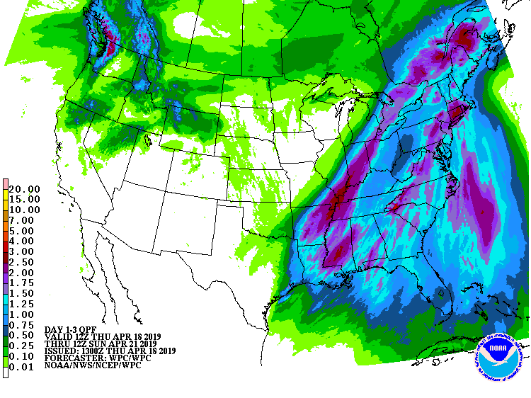
While damaging winds, large hail, and isolated tornadoes are all possible, very heavy rains are a near-certainty for many. According to the National Weather Service’s Weather Prediction Center, widespread rains in excess of 2″ in the eastern United States could set the stage for flooding. Some heavier thunderstorms and thundershowers may also create downpours that could lead to short-term flash flooding. The National Weather Service cautions: “Turn around, don’t drown; never drive through flood waters.”
