• Skip to primary navigation
  • Skip to main content
  • Skip to primary sidebar

Weatherboy

Weatherboy Weather News, Maps, RADAR, Satellite, and Forecasts.

  • Local
  • Earth Science News
  • RADAR
  • Current Warnings
  • Satellite
  • Current Maps
  • Forecast Maps
  • Video

Severe Storms in Mid Atlantic, South Expected Today

by Weatherboy Team Meteorologist - May 4, 2021

The latest Convective Outlook shows two pockets of severe weather expected today: one over the south, the other over the Mid Atlantic. Image: weatherboy.com


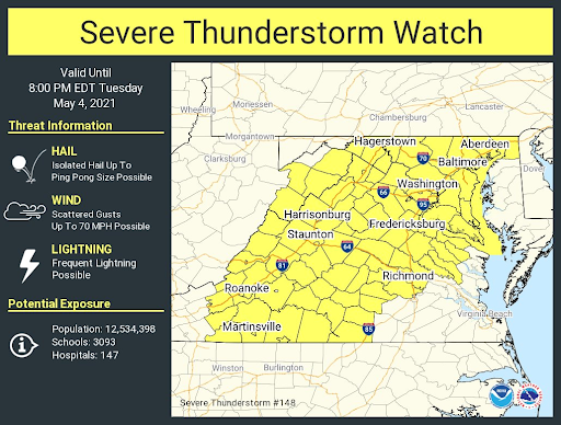
A variety of springtime severe storms are forecast to pop-up today in portions of the Mid Atlantic and South, prompting the National Weather Service to issue Severe Thunderstorm Watches across several states.

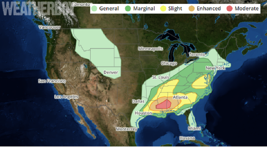
The greatest threat of severe weather will be over the southern states in an area stretching from eastern Texas east to South Carolina and north to western Kentucky. Within this area, the greatest risk of severe conditions is over east-central Louisiana, central Mississippi, and west-central Alabama. Several clusters of ongoing convection from southeast Texas  to the southern Appalachians are expected to blossom today; a moist and moderate to strongly unstable air mass exists across a broad region here making conditions ripe for severe weather.

The National Weather Service is issuing Severe Thunderstorm Watches like this one ahead of today's weather event. Image: NWS
The National Weather Service is issuing Severe Thunderstorm Watches like this one ahead of today’s weather event. Image: NWS

The National Weather Service’s Storm Prediction Center says  storms should expand in coverage and intensity this afternoon with a corresponding uptick in wind damage potential expected aside from a persistent severe hail risk.  Widespread damaging winds, some significant, and brief tornadoes will be possible as the most potent area of activity evolves across the lower Mississippi Valley into Alabama.


Beyond the south, there’s also a risk of severe storms over portions of the Mid Atlantic from northern North Carolina into Virginia and eastern Maryland.  Here, the Storm Prediction Center says there  should be  scattered damaging winds from strong to isolated severe gusts as multicell clusters spread towards the Mid-Atlantic Coast.

With the threat of severe weather likely, the National Weather Service has issued Severe Thunderstorm Watches across portions of Maryland, Virginia, West Virginia, Arkansas, Mississippi, Georgia, and Texas today. A Tornado Watch is also in effect for portions of Alabama, Mississippi, and Arkansas.


Primary Sidebar

Sponsored Ad

Search

Latest News

  • Severe Weather Threat Returns to Mississippi Valley on Friday
  • Deadline for SBA Aid for Kauai Drought Coming Soon
  • Another Atmospheric River Event Slams into West Coast; More Epic Rain, Snow Expected
  • Anniversary of 1964 Great Alaskan “Good Friday” Earthquake and Tsunami
  • Tornado Watches, Warnings Issued as Severe Weather Impacts Louisiana, Mississippi, Alabama, & Gerogia
  • After Violent Night, Storms Shift to Ohio and Pennsylvania
  • Preliminary NTSB Report Shows Something other than Turbulence Killed Passenger on New England Flight
  • SEVERE Geomagnetic Storm Alert Issued; Massive Aurora On Display in North America
About | Careers | Contact | Contests
Terms | Privacy | Ad Choices
Weatherboy is a (R) Registered Trademark of isarithm LLC, All Rights Reserved.
All content herein is Copyright by Isarithm LLC 1997-2022