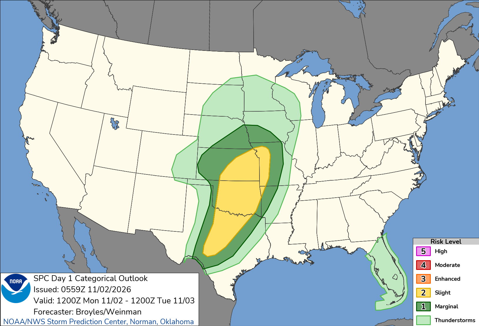
A rapidly strengthening storm system will push into the Plains on Monday, threatening severe thunderstorms with damaging winds and a few tornadoes from north Texas to Kansas and western Missouri, followed by a risk of flash flooding into the Mid-South on Tuesday, the National Weather Service said.
The Storm Prediction Center in Norman, Oklahoma, placed parts of the southern and central Plains into the lower Missouri Valley under a Slight Risk, level 2 of 5, for severe weather. “Severe thunderstorms with damaging wind gusts and a few tornadoes are expected across parts of the southern and central Plains from this afternoon into tonight,” the center said in its outlook issued just before midnight Sunday.
The threat is part of a sprawling storm that FOX Weather said could affect more than 35 states this week, after days of flooding in Arizona and the Four Corners region.
The Weather Prediction Center in College Park, Maryland, said a low-pressure area in the central High Plains would “quickly deepen” while moving across the northern Plains.
“As a cold front emerges later this afternoon, the Central and Southern Plains can expect a round of severe thunderstorms and isolated to scattered flash flooding,” the center wrote.
Storms Could Start as Supercells
The Storm Prediction Center said dew points would climb into the mid to upper 60s across much of Texas, Oklahoma and eastern Kansas, with strong winds aloft favoring rotating storms.
The weather service office in Norman said storms were likely to develop along a dry line from southern Kansas through western Oklahoma and into western North Texas by afternoon. Early storms could be discrete supercells capable of damaging wind gusts, tornadoes and some large hail, the office said.
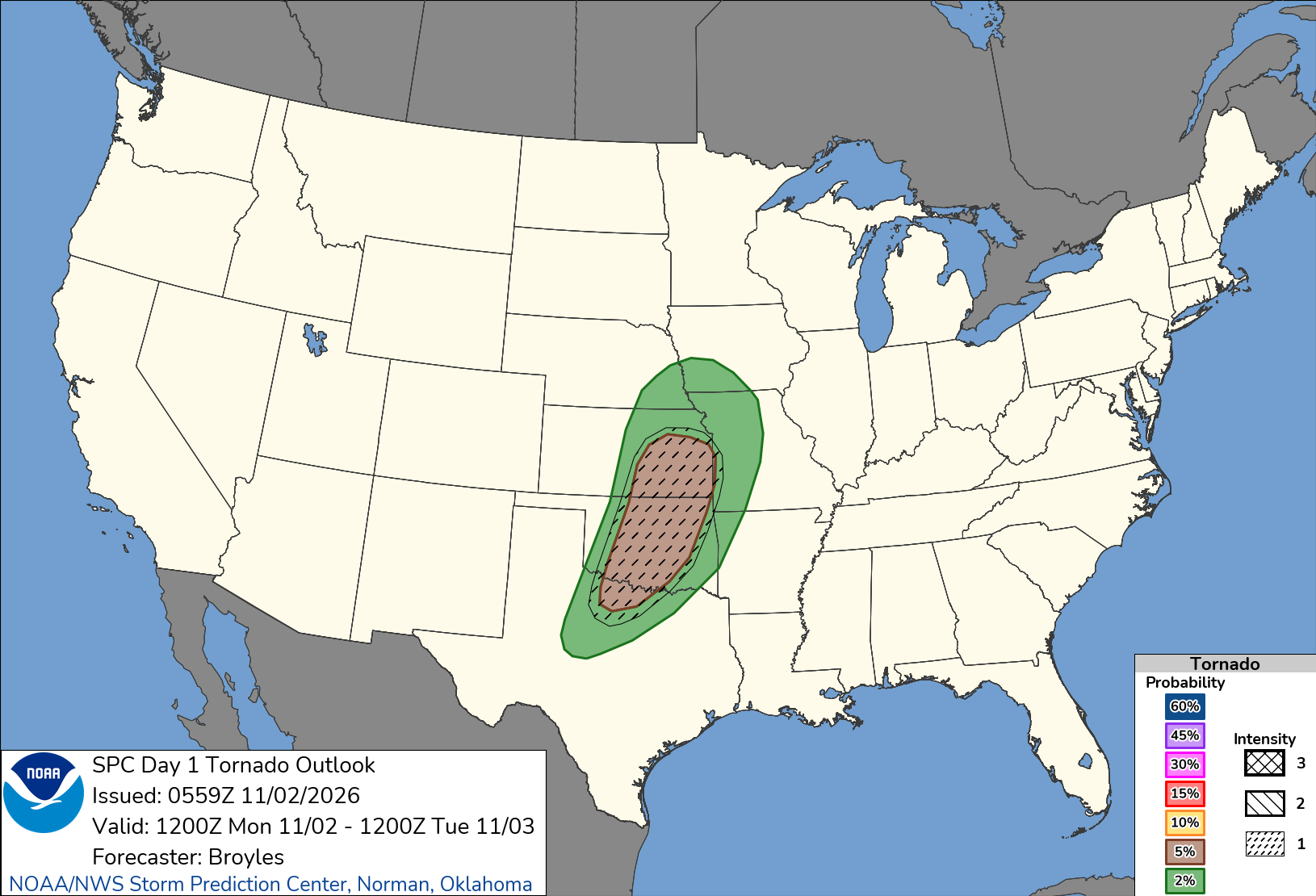
As the low-level jet stream strengthens Monday evening, the Norman office said, the wind profile will support “a window of time where a strong tornado or two will be possible.” Storms are then expected to merge into lines, with damaging winds and tornadoes embedded in the line becoming the main hazards.
The Storm Prediction Center called storm mode “the main question for this event,” saying a greater tornado threat could develop across Oklahoma or southeast Kansas “if a cluster of discrete cells can persist into the late afternoon or early evening.”
In Texas, storms are expected to develop over west-central and northwest Texas by midafternoon and move into north-central Texas by early evening, where the center said “the greatest tornado threat should be concentrated.”
The weather service office in Fort Worth forecast highs in the mid to upper 80s, about 15 to 20 degrees above average. The main line of storms is expected to reach the Interstate 35 corridor around 11 p.m. Monday and leave the region around 8 a.m. Tuesday, the office said, with damaging wind gusts the main concern and the chance of “a brief QLCS tornado or two.” QLCS stands for quasi-linear convective system, a line of storms.
Kansas and the Ozarks
In Kansas, the weather service office in Wichita said forecasters would be watching closely between 2 p.m. and 5 p.m. for new storms near or west of Kansas Highway 14 in central and south-central Kansas. The first storms could produce damaging winds, large hail and a few brief tornadoes before turning mainly into a damaging wind threat, the office said.
The Springfield, Missouri, office said its severe threat would come mostly after 6 p.m. and last into Tuesday morning, with damaging wind gusts up to 70 mph and a few tornadoes possible. Forecasters there said supercells could reach as far east as Joplin and Nevada, Missouri, and that if a tornado does occur in the area the Storm Prediction Center highlighted, there is a 5% to 10% chance it could be as strong as an EF2.
The office cautioned that the energy available to storms would be “much lower than we typically see in the spring,” and the threat “could underperform.”
“We can get tornadoes any time of the year in Kansas and Missouri, so its best to be prepared even in the month of November,” forecasters wrote.
The Tulsa office said the threat for tornadoes along the leading edge of the line “may increase after dark” across far eastern Oklahoma and western Arkansas.
The office recommended “having multiple ways to receive warning information, including ways designed to wake you up.”
No severe weather watches were in effect early Monday, according to the Storm Prediction Center.
