
Image: Staff Sgt. Marc Morgenstern/107th Mobile Public Affairs Detachment, Florida National Guard
The St. Johns River held at record levels near Cocoa on Saturday morning, leaving neighborhoods west of the Space Coast under water and pushing a slow-moving flood crest north toward Seminole, Volusia and Lake counties after days of torrential rain.
The U.S. Geological Survey gauge on the river near Cocoa read a provisional 18.76 feet at 6:15 a.m. EST Saturday. The previous record, 17.55 feet, was set in October 1953. Major flood stage at the site is 17 feet.
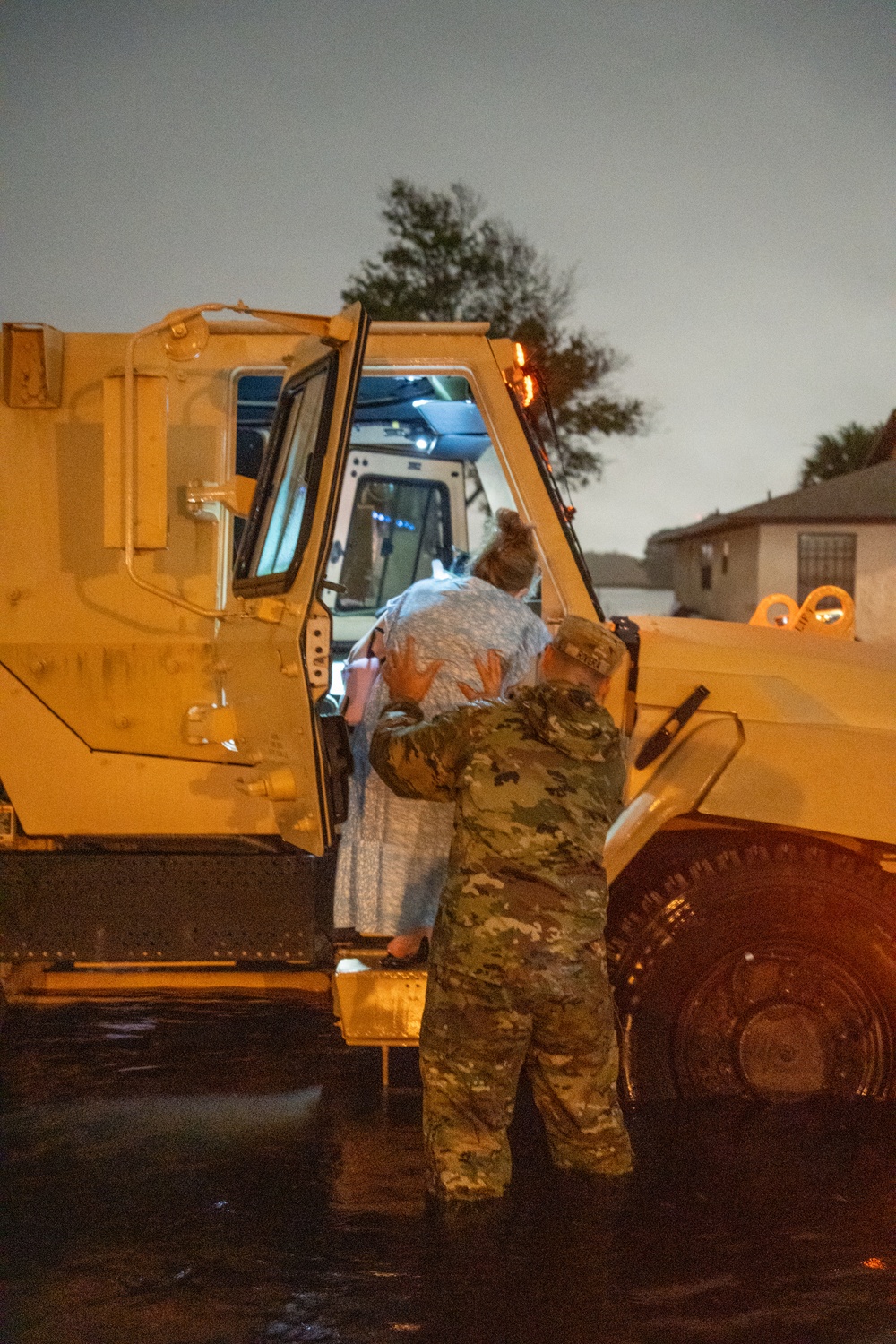
Image: 1st Lt. Brandon Miles/Florida National Guard
The National Weather Service in Melbourne said “extreme rainfall over the headwaters of the St. Johns River has caused the river near Cocoa to reach Major Flood Stage, well above its previous record flood stage.” The agency forecast the river to remain steady near 18.8 feet this weekend into early next week, and the river flood warning remains in effect until further notice.
At 17.2 feet, a level the river passed earlier this week, the weather service said water enters homes along the river in the Lake Poinsett area west of Cocoa and in low-lying homes in the Silver Pines subdivision in Rockledge and the Shakespeare Park area of Cocoa. Providence Road west of Cocoa becomes impassable at that level, cutting off access to homes in the Mullet Lane and Bass Road area.
Two Feet of Rain in Three Days
The flooding followed a multiday deluge that was strongest along the Brevard and Volusia coasts. A National Weather Service public information statement issued Friday listed 72-hour totals of 24.26 inches 1 mile north of Cocoa Beach, 22.49 inches 3 miles south of Titusville and 22 inches on Merritt Island, according to The Space Coast Wire, which published the figures from the statement. The weather service cautioned that the reports came from a mix of sources and not all are considered official.
Melbourne International Airport recorded 5.34 inches Thursday, breaking the Nov. 19 daily record of 2.80 inches set in 1987, and its November total reached 22.62 inches by Friday afternoon, compared with a normal of 1.70 inches by that date.
Daytona Beach set a daily rainfall record Friday with 2.84 inches, breaking the old mark of 1.21 inches set in 1952, the weather service said in a record event report early Saturday.
On Friday, the Weather Prediction Center placed the Space Coast and Volusia County under a high risk, level 4 of 4, for excessive rainfall, the highest category it issues.
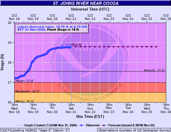
Image: NOAA/National Weather Service, National Water Prediction Service
Airboats in Residential Streets
The water has forced residents from their homes and left some neighborhoods reachable only by boat. Florida Fish and Wildlife Conservation Commission Lt. Grant Eller told WKMG-TV that about 80 officers and 13 airboats had been deployed to the Cocoa area, working with the Brevard County Sheriff’s Office, Florida Highway Patrol and Florida National Guard.
“It’s an event that we haven’t had in quite a long time,” Eller said.
The commission told the station around 4 p.m. Friday that approximately 120 people had been rescued in Brevard County and well over 150 in Volusia County. A newer official total was not available early Saturday.
Florida Army National Guard soldiers assigned to Bravo Battery, 1st Battalion, 260th Air Defense Artillery Regiment conducted high-water rescue missions in Rockledge on Thursday and evacuated residents affected by severe flooding, according to photos and captions released by the Florida National Guard.
Brevard County Sheriff Wayne Ivey said at a news conference Thursday that no deaths had been attributed to the flooding.
“While we may have substantial property damage, we’ve got vehicles that are damaged, businesses that are damaged, right now we have absolutely no one that has lost their life from this storm,” Ivey said, according to CBS News. “Very minimal injuries across the board.”
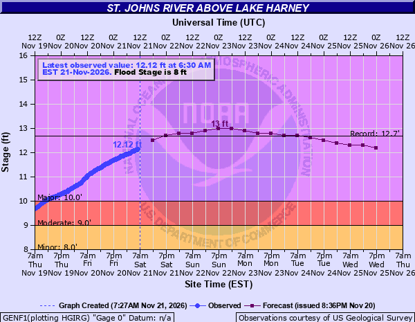
Image: NOAA/National Weather Service, National Water Prediction Service
Crest Moves Downstream
Because the St. Johns flows north across an exceptionally flat landscape, the flood is moving slowly. The St. Johns River Water Management District said in a Nov. 20 statement that the river descends only about 1 inch per mile, allowing levels to stay elevated long after the rain ends. The district said its reservoirs, canals and water-control structures in the Upper St. Johns River Basin were temporarily storing about 60 billion gallons of water that would otherwise be flowing downstream.
Upstream of Lake Harney near Geneva, the river stood at a provisional 12.12 feet at 6:30 a.m. Saturday, already in major flood. The weather service forecast a crest near 13 feet late this weekend, above the record of 12.7 feet shown on the agency’s river forecast graphic. At 10.8 feet, the weather service said, water covers State Road 46 near Jungle Road and Prevatt Road, and standing water on secondary roads near the river deepens to more than 3 feet in some areas. The Florida Department of Transportation has closed State Road 46 between Sanford and Mims, The Daytona Beach News-Journal reported.
Near Sanford, where the river was at 6.8 feet Friday evening, the weather service forecast major flooding by midweek. Near DeLand, the river read 5.04 feet early Saturday and was forecast to reach about 6 feet early next week, above the 5.3-foot level at which the agency said major flooding affects many structures and marinas.
At Astor, the river reached 4 feet Friday evening, well above its 2.3-foot flood stage, and was forecast to rise to 4.2 feet by midweek. The weather service said flooding at that level is long-lasting, “with levels taking weeks to months to return below flood stage,” and water rescues will be necessary.
Seminole County Emergency Manager Alan Harris said Thursday that flooding along the river in his county could last through mid-December, WESH-TV reported.
Emergency Declarations and Closures
Volusia County declared a local state of emergency, and the cities of New Smyrna Beach, Port Orange and Edgewater also declared emergencies, according to WKMG-TV and The Daytona Beach News-Journal. Volusia County officials said Friday that portions of International Speedway Boulevard, LPGA Boulevard, Dunlawton Avenue, Spruce Creek Road and Maytown Road were closed by flooding.
Brevard County Emergency Management opened shelters at the Walter Butler Community Center in Cocoa and the Joseph N. Davis Community Center in Melbourne for the general public, people with special medical needs and families with pets.
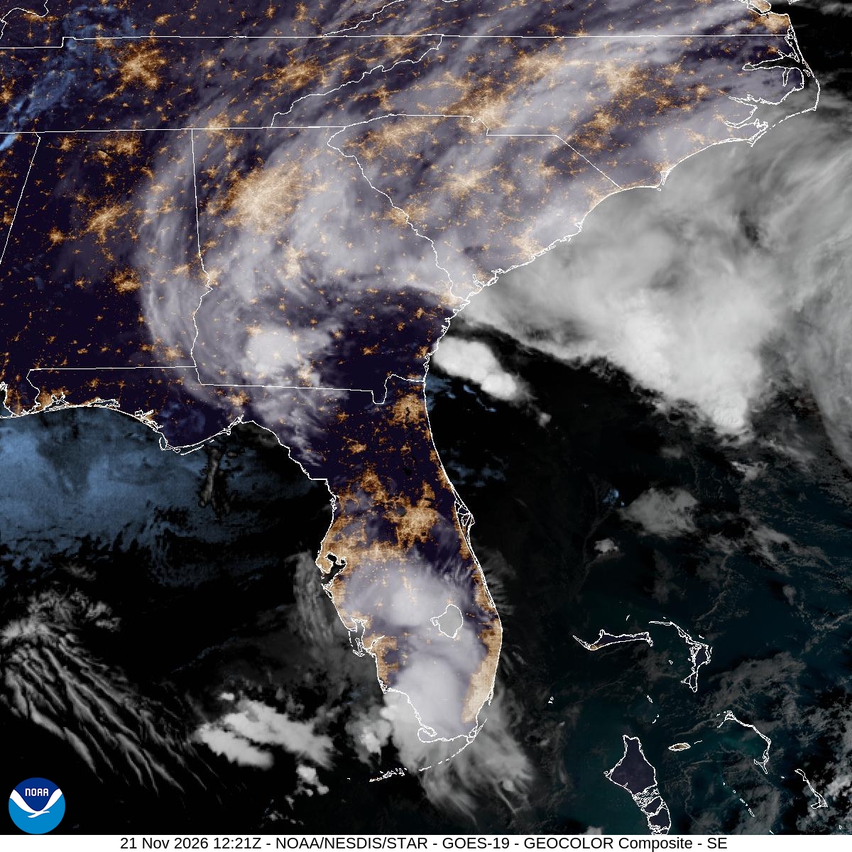
Image: NOAA/NESDIS/STAR
More Showers Saturday, Another System Midweek
The weather service in Melbourne said a weak low over the Florida peninsula would lift northeast Saturday, bringing a 30% to 60% chance of showers and isolated storms to east-central Florida, mainly from 1 p.m. to 8 p.m. The agency said rainfall of half an inch to 2 inches is possible and “could aggravate sensitive locations that remain fully saturated and flooded.” The Melbourne office said a marginal risk, level 1 of 4, of excessive rainfall remained focused on the coast, while the Weather Prediction Center placed parts of Florida under a slight risk, level 2 of 4, for Saturday.
Mostly dry weather is expected Sunday and Monday, but forecasters said another low could form over the Gulf and move across the peninsula Tuesday and Wednesday, bringing increasing rain chances. Any additional rainfall will lead to more river rises, the weather service said.
Officials urged residents never to drive through flooded roads or around barricades.
